July 31, 2010

Trees, Glorious Trees

Another fine day in the redwood forest. Along the way, we shared curvy Kings Mountain Road with what appeared to be a local chapter of the BMW Club. One M3 was stranded on Skyline, more or less off the road (but blocking half of the intersection), hood raised and all four shiny tailpipes silenced. Should you find yourself in a similar situation one day, do turn on your emergency flashers.

It seemed that Kings Mountain was exacting its toll today. On the way down, I passed a motorcyclist walking his machine down the hill. "Wish it had pedals," he remarked.

Bracketed by these breakdowns, we enjoyed our up-and-down day in the trees. My hands started going numb as I descended Star Hill—not from gripping the brakes, but from the chill. I have enjoyed this cool summer.

Waiting for my ride buddies before descending Kings Mountain, I watched a timid Jaguar make the turn from Skyline. By the time we were ready to roll, I had forgotten the sedan ... until I caught him, never taking his foot off his brakes. Descending at his speed was painful, and inhaling goodness-knows-what from his brake pads was unhealthy. Since it was not safe to pass him, I pulled off the road to grow some space between us.

Pausing to regroup at the base of Kings, I smiled when I saw the guys from Plus 3 Network approaching. My Plus 3 vest not only kept me warm today, it earned me three high-fives as they cruised past. "Looks great on you!," one shouted. Orange, yes.

July 24, 2010

The Hamilton Habit

Such an inviting plaza for a summer picnic, don't you think? It happens to be on top of a mountain ...

Having convinced two riding buddies that half is not enough, we rolled out early to climb up to the starting point for today's club ride—which was scheduled to cover only the upper half of Mt. Hamilton. It must be a cool summer if this registers as an appealing ride in late July.

Curiously, the temperature was warmer on the upper slopes. Warm enough to put my ride buddies into some difficulty, I would later learn. Merrily pedaling ahead, exchanging greetings with the many riders who passed me, I was oblivious to their discomfort. [Some friend, I am!]

I arrived at the sharpest, steepest hairpin near the top at just the right moment for a little drama. Two motorcyclists passed me on the approach, and as the second one entered the steep curve, he stalled his bike and went down. The only real injury was to his pride, and likely some regrets about fresh scratches on his BMW. I rounded the corner as he extricated himself from his machine and began the struggle to set it right. In this, I could be of no use; a larger cyclist behind me did stop to lend some muscle to the effort. Raising that beast from a flat surface would be hard enough—now imagine what was required to push it upright with all that weight downhill from the wheels.

Once everyone had recovered at the top, I led off down the hill. The car that was preparing to leave the observatory at the same time caught me only after I stopped to wait for my ride buddies at the base of the first descent. With all the gravel I had noticed in the corners, I took it easy. [Honest. One cyclist even passed me.] On the way up, one of the riders in our group had caught me on this last ascent. "I was behind you," he said, "and I was sure I would catch you on the descent, but I couldn't." Shaking his head, he added: "I thought I was a good descender."

July 17, 2010

Laughing Crows

They were laughing at me, I am sure of it, those crows. Cackling at the cyclist on the steep bit of San Benancio Road, moving so slowly she could not outrun the buzzing horsefly orbiting her head.

I chose a distant club ride today to explore some new territory. As we met more cyclists traveling toward us, it was clear that we were taking the more difficult approach. But that was okay, we would climb the hill from both directions.

San Benancio Canyon is Steinbeck country—mostly sprawling ranches, with bits of suburbia on the fringe near the highway. Turkey vultures, lots of quail, and a red-tailed hawk were among my wildlife sightings for the day. From the sun-baked summit, I eyed the cool fog bank hanging over Monterey with envy.

Splat! A large insect hit one lens of my sunglasses with enough force to leave, shall we say, residue. [Not because I was moving so fast at the time—the unfortunate victim was.]

All in all, a nice road if you find yourself in that neighborhood, but a bit far off the beaten track to venture for such a short ride (20 miles).

July 11, 2010

Dicey Descending

This is a blind curve. What you cannot see around this bend is dangerous—the grade drops steeply into an immediate hairpin turn that hooks left.


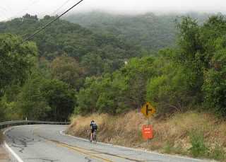
The extra orange sign was placed to warn cyclists participating in a charity ride to slow down; normally, on this curve, it is just you and your best judgment.
Tip #1: If you cannot see around the bend, be prepared to stop.
You normally brake to reduce your speed before heading into a curve; be especially cautious when you cannot see what surprise might be lurking around the bend.

What is wrong with this picture?
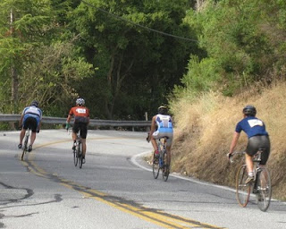
Everything.

Let's start with the guy on the left. He is on the wrong side of the double yellow line. [Did I mention that this is a blind curve?]
Tip #2: Stay in your lane.
Why do you suppose he is over the double yellow line? Perhaps he noticed that the other three riders are not skilled descenders, and he wanted to pass them.
Tip #3: Do not pass on a blind curve.
Even if you can stay in your lane. You do not know what you will find around the bend. If you need to veer suddenly to your right, you will endanger the cyclists you just passed by cutting them off. If you need to veer left and there is oncoming traffic ... well, enough said.

Next, let's consider his position on the bicycle. His bike is tilted into the turn—in this case, to the right. That is good. His feet are level, with pedals at the 9:00 and 3:00 positions. That is less good. I saw this on every mountain bike heading into that curve. A mountain-biking friend tells me that this is proper mountain-biking technique, to avoid clipping a pedal on a rock, tree root, or other miscellaneous obstacle on the trail. I am not a mountain biker, and this cyclist is riding a road bike on a road.

What is the stable position on the bike, when cornering? [Hint: Did I mention that the other three cyclists are not skilled descenders?]
Tip #4: Lean your bike into the curve, with your leading (inside) knee up and your weight planted firmly on the extended (outside) leg, pedals at 12:00 and 6:00.
Your body should be nearly upright, with the bike tilted underneath you. Like the pros in this photo I snapped during the last San Francisco Grand Prix,

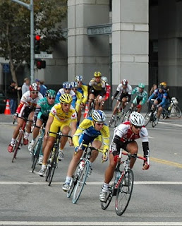
cyclists on our local curve need the same good form:

Think: Right turn, right knee up. Left turn, left knee up. [If you tend to confuse "right" and "left," come up with your own mantra.]

Maybe these were lucky shots, and I just happened to catch the riders' legs at a particular moment during the pedal stroke? Nope. They were all coasting downhill.

In the second photo at the top, three riders have positioned their legs exactly opposite of where they should be. What could go wrong? Well, as the bike rounds the bend and naturally tilts into the turn, they risk clipping the inside pedal (extended leg) on the pavement and crashing. Notice their upright posture. With their weight distributed through the extended leg beneath them they risk toppling over as the bike tilts. I can only imagine how unbalanced this must feel; I am not about to give it a try.

What about lane position? That guy in the blue jersey is in the middle of the road, and the guy in the white jersey is right next to the double yellow line. Shouldn't they keep as far to the right as possible, like the guy in the first photo above?

No.
By "taking the lane," they are more visible to traffic approaching from behind, and they send a clear message: It is not safe to pass us on this curve. There is no room to share the lane; you would squeeze us off the road. [They are really taking a good line through the curve, but let's call that an advanced topic.]
Bonus Tip #5: Descend at your own pace.
Your skills may not match those of the rider ahead of you; don't give chase. If you are less skilled, you risk losing control of your bicycle.
Bonus Tip #6: Before the curve, slow to a comfortable speed you are willing to carry through the curve.
You want to roll through the curve; if you grip your brakes and your wheels lock up, they are not rotating and you will skid (or worse).
Bonus Tip #7: Look where you want to go.
Your visual system is powerful. Your body will follow where your eyes are tracking. If you look at the edge of the road, guess where you will end up?

Water Boys

This was the third year that the LIVESTRONG Challenge rolled through San José, but the first time that I chose to support the event as a volunteer. It takes a good cause to rouse me from bed on a Sunday morning at 4:30 AM, to report for duty downtown at an hour when I am usually still sound asleep (even on a weekday).

The organization understands the value of recruiting volunteers from the local bike clubs—we know the terrain and the route well. As we assembled for our briefing, there were so many familiar faces that we joked about who would lead the ride today. We were released a few seconds ahead of the first participants, and for the first couple of miles we enjoyed a dream ride as we were paced by official vehicles through deserted city streets in a rolling road closure.

Despite following a shortcut to reach our assigned posts ahead of the pack, I was passed by the elite riders as I ascended the first real climb of the day. I positioned myself just above a tricky downhill curve on the course, where I would repeatedly warn riders "Sharp turn ahead!" My approach was effective—none of our riders crashed. [I heard that one of the elite riders ahead of us went down. They should know better.]

With the responsibility to watch 1,000 or more riders head into this familiar curve, I recognized a valuable opportunity to capture images of cornering technique on a bicycle. Whenever there was a sufficient break in the stream of riders heading downhill, I would point my camera at the haphazard descenders.

By the time the last of the 50-milers straggled by, I was so far behind the last 65-mile rider that I would never catch up to finish my job for the day as a riding course marshal. Arriving at the next rest stop as they were packing everything away, I stuffed my pockets with energy bars and accepted a ride forward to the next stop.

Continuing along the route, I monitored the riders I caught for signs of trouble. Throughout the day, I was fortunate not to face any serious incidents. There were riders whose legs seized up with cramps, in need of some electrolytes. There were riders who were fatigued, not having trained adequately; those I met needed only some encouragement and advice to sustain them up the next hill and on to the finish. I was surprised to learn how many people traveled from afar to do this ride. I was inspired by a cancer survivor from Toronto who was working hard to complete the 50-mile route. I was proud to ride alongside a woman from Idaho, riding 50 miles alone—the longest distance she had ever attempted. When she crossed the finish line, I was there to give her a high-five.

The two longer routes include a serious challenge: climbing Metcalf Road. Rumor had it that when he rode the inaugural San José LIVESTRONG Challenge in 2008, Lance Armstrong was "impressed" with Metcalf. As one of the century riders passed me on the hill, I remarked that this was the second time I had climbed Metcalf this year, and that was one time too many. "Or two," he replied.

This ascent was memorable, not only for the cheering section or the guy belting out his improvised tune about the hill, but especially for the water boys. A couple of moms set up along the roadside under beach umbrellas with their sons—armed with Super Soakers. Loading up as we approached, if you agreed to get wet they would enthusiastically take aim. Sheer brilliance! I am not sure who had more fun with this, the riders or the boys. Farther up the hill, a guy with a bucket of ice water wrung out a huge sponge over my head. Climbing Metcalf will never be this good ... well, until next year. Boys, I'm counting on you!

July 10, 2010

Into the Woods

With plans to ride on Sunday, I expected to designate Saturday as a rest day. But with my Sunday route uncertain, I was loath to squander such prime cycling weather. Most conveniently, a club ride was scheduled to cover some favorite terrain in the Santa Cruz Mountains. Given that the starting point was close to home, I was able to catch the finish of Stage 7 of the Tour de France for inspiration before setting out with our little group.

First stop: Wrights Station, which lives on only in the history books. Remnants of the town are long gone, and what remains of the railroad tunnel is barely visible from the road. The road is not in the best condition and quite steep; it is one of my least favorite descents. It has been a while since I last visited here, and the climb seemed much easier than I remembered.

We dropped down over the summit of the Santa Cruz Mountains, but not wanting to descend all the way to the coast, three of us split off from the rest of the group before wending our way back up through the redwood forest. On a decidedly uphill stretch, a local resident smiled and shook her head. I don't know how you guys do it!

July 5, 2010

One Cool Canyon

What better way to start a holiday morning than to get up and out on the bike early? With the promise of another hot day ahead, a short ride into a cool canyon was enticing.

Highway 9 has recently been repaved from Los Gatos to Saratoga, and never so traffic-free as on this holiday morning. I rode to the starting point and joined the group as we headed for the leafy shade of Stevens Canyon. We proceeded ever-so-slightly uphill to the end of the paved road, then headed back down for some fun on a pair of short, friendly climbs.

On my way back, I tried the service at the new bike shop in town, Mike's Bikes. They were cheerful and helpful, confirming my suspicion that my bike was due for a new chain. Twenty minutes later, a happy customer rolled out of the shop with a much happier drive train, to celebrate with lunch in the park.

July 3, 2010

Blazing Saddles

Before I had traveled two blocks from home, I was passed by another cyclist. Once I was warmed up, I was surprised to pass him and open up a substantial gap, although he was a big guy, riding in casual attire and without a helmet. He must have felt compelled to catch me; when we met at a traffic light, he was out of breath. His eyes grew wide when he learned that I would be riding from San José to Morgan Hill, and back. After pancakes, of course—I was on my way to our club's traditional Independence Day breakfast. With the promise of pancakes ahead and a flat route, I averaged 17 mph.

The club had a record turnout: nearly 200 members, many bedecked in red, white, and blue. Post-pancakes, there were many rides from which to choose. This year, I had been convinced to co-lead one. A dozen riders headed out with us into the dry, rolling hills on our trip to Uvas Canyon County Park. We warned them that we had carelessly underestimated the mileage [by a whopping 35%], but they simply shrugged. A hardy bunch, many had ridden to the start that morning, like me.

The route itself was a success. Being mostly unfamiliar with the area, I relied on a combination of satellite map imagery and Streetview to choose roads with bike lanes, find controlled intersections for left turns, and confirm a pass-through blocked to vehicular traffic.

With the hills and heat, needless to say I did not average 17 mph throughout the day. I was happy to enjoy the redwoods and cool shade at the park, and delighted to find the rest of the group waiting for the last of us in the shade of a giant eucalyptus tree on the return route. Miraculously, despite the tire-softening heat and the usual abundance of broken glass in the bike lanes of San José, we got through the day without a single flat.

At the end of the ride, wilting in the heat and caked with sunscreen, salt, and grime, I returned home at a snail's pace. Sixty-seven miles, a modest 2,130 feet of climbing, some 2400 Calories burned.

June 27, 2010

Spreading Sunshine

Someday, when I look back at all of this, I know I will remember the faces of so many little boys pressed against the windows of passing cars. One scolded by his father for nearly climbing out of his car seat, trying to get a better look.

Fueling up today, I was approached by two fellow customers. This was not unusual. Both of them were women—that was unusual. The first question: How fast have you driven it? Have you wound it all the way out?

Truth be told, I am really rather shy. I am not adept at talking to strangers. Needless to say, "shy" is not exactly compatible with driving about in a conspicuous car.

Today's excursion had a little bit of everything. Wide-eyed children in passing cars on the freeway. Adults snapping photos with cellphones. Scenic, curvy, rural California roads. Motorists who pulled aside, unbidden, to give me the road.

An approaching motorcyclist tipped me to a patrol car lying in wait ahead. With four or five sedans and SUVs in my wake, I cruised past at a respectable speed. Another patrol car just happened to appear as I rolled into town. 25 mph? Watch me. I can do 25 mph.

At my halfway point, I was tempted to turn around and enjoy the same route back home. Sensing that I had exhausted my karma with the local authorities, I opted for the freeway instead.

An unexpected dividend earned through hundreds of cycling trips: How to get home on back roads. The freeway was boring (and jammed). Coastal views, curvy roads, redwood trees.

Another of my shortcomings: I do not enjoy driving long distances. Any trip over an hour and I start to feel drowsy. Evidently, in this I have been granted an exemption.

June 26, 2010

All is Not Lost

What if the club schedules a ride, and no one shows up? I arrived early for today's outing in Carmel Valley, and waited for 30 minutes past the scheduled start time with no sign of a fellow rider. Having traveled a long way, I set off to climb Robinson Canyon Road on my own.

Before I moved to California, I fell in love with nearby Pacific Grove. Once here, I would quickly realize that the residents shiver all summer under the influence of the cold, gray marine layer. I regretted not bringing a jacket, but knew I would warm up on the climb.

Fifty yards from the turn onto Robinson Canyon, I recognized my mistake. There was the Safeway parking lot with the coffee shop and the gas stations ... I had parked in a different Safeway parking lot, with a different coffee shop and gas stations.

The sun was breaking through at the summit of Robinson Canyon Road, and I descended into a lovely valley. Almost instantly, I was too warm; I rolled down my arm warmers and continued exploring. Having studied a map of this area last summer, I had a vague memory that I could follow another road back to Carmel Valley. Stopping to take a photo on the way up, I observed that the edge of the road really is the edge of the road: a few inches of dirt next to the pavement, then a sheer drop into the canyon several hundred feet below. I was enjoying my little adventure, but exercising caution. Out in the middle of nowhere, alone—best not to risk any mishaps.

Question: If you are passed by a FedEx van, are you really out in the middle of nowhere?

Happily, MyTracks on my Android phone showed me exactly where I was, and I confirmed that I was looking for Rancho San Carlos Road. I continued to a shady redwood grove for lunch, and was surprised to see that I had missed my turn. The reason would soon become clear: like the other side roads along the way, it was gated. Private. This land is all part of the cleverly-named Santa Lucia Preserve, which looks like a wonderful place to visit ... if you happen to be one of its 300 residents.

And so I would retrace my path back to the start. The marine layer had thickened at the summit, thanks to the prevailing onshore wind. A nervous quail skittered into the brush when I stopped to pull up my arm warmers. I completely overlooked the raptor in the tree above me until I clipped in and it took flight. I caught sight of what was likely a ferruginous hawk, just a few feet overhead. I was not disappointed to descend Robinson Canyon.

Sometimes, being lost is a good thing.

June 19, 2010

Half is Not Enough

When we reached the turn-around point at Grant Ranch Park, the summit of Mt. Hamilton was so alluring that I could not resist. How could I climb only halfway up the mountain today?

I continued with the rest of our little group on our planned route along the easy eastern approach to the summit of Quimby Road before dropping back down to resume my climb to Lick Observatory. It was a spectacular day to head up the mountain—cool and breezy, with little traffic.

Most of the traffic was well-behaved, with the notable exception of one driver who crossed the double yellow line completely into the opposite lane on a blind curve to pass me. Knowing it was not safe for a car to pass, I had moved to the center of our lane to send a clear message: Do Not Pass Me. Had there been a cyclist or vehicle coming downhill in the other lane, I would have been collateral damage. I saw the Sheriff three times before that, but he missed this moment of stupendously dangerous driving.

I did not set out this morning to climb all the way to the summit. Cool day? One water bottle. Not much distance? Eat a sandwich after the ride. I consumed everything I had stuffed in my pockets: one Balance Bare bar, one molten PowerBar, a dozen peanut butter-filled pretzel nuggets, and three Clif Shot Bloks. Plus a few cherries shared by a fellow rider, and the best energy bargain in the observatory's vending machine, a Nature Valley Sweet and Salty Peanut bar. Intake: 876 Calories. Burned: 2040 Calories.

Free to be a tourist, I enjoyed the wildflowers and lingered at the top. Along the way, I pocketed a shiny nickel that caught my eye, saw my first skink, and watched a pair of acorn woodpeckers for awhile. A friendly biker (of the motorized sort) offered to take a picture of me ("to prove you were here!"), before confessing that they had "cheated" (driving, rather than pedaling, to the top).

Just yesterday a friend commented that he does not enjoy descending Mt. Hamilton. What's not to like?! So long as you respect the gravelly curves where the hillside is chronically crumbling, and keep an eye out for the suicidal squirrels ... His hands hurt, he explained. You're braking too much, I replied.

A fabulous day on the bike: 42 miles, 5,635 feet of climbing, maximum speed 35.3 mph.

June 17, 2010

Oxymorons on Hicks

There are a couple of approaches to this view at the summit of Hicks Road, which was particularly striking in the warm glow of early evening. The climb from the Los Gatos side is painfully steep, and I was grateful that we were not taking that route. Instead, we were taking the easier route, climbing Hicks from the San Jose side. Which is ... painfully steep. From The Complete Guide to Climbing (By Bike) in California:
After a shallow start, this side of Hicks Road contains one of the steepest miles in the state.
I had the uncommon opportunity to be home from work early enough to join one of the club's regular after-work rides. With the summer solstice just a few days away, tonight's ride could be a long one. Facing that tough climb, I had some doubts about whether I could pedal fast enough to stay with the group and finish before the sun set. When I lost them on the flats, I would catch them at a traffic light. When they regrouped at a key intersection, I would keep pedaling for a head start on the next hill. I used every downhill to pull ahead, so the group would not have to wait too long for me at the top of the next hill.

I managed to cover 27.8 miles, ascending 2,170 feet along the way. My maximum downhill speed was 39.3 mph, while my minimum uphill speed was ... well, let's not go there. [Okay, okay ... 3.2 mph.] All in a day's work.

June 12, 2010

Some is Better than None

Another view from a bridge—this week, of a solo rower on the Lexington Reservoir.

This morning, the spirit was willing; the body ... not so much. Had I not committed to meet up with a ride partner, I simply would have stayed at home. I considered showing up in street clothes to explain and apologize.

My original plan for the day was to ride up and over the Santa Cruz Mountains to the coast with a group, have lunch at the beach, and then head back up and over the mountains. The climb to the summit is gentle, and I guessed that I could make it that far today no matter how crummy I felt.

Spinning uphill in the redwood forest felt better than I expected, but I did take it easy. The descent was so smooth I was almost lured into repeating the climb just to glide back down. I did the prudent thing instead, and climbed back into my car. Ten miles of cycling (half of it uphill) was far better than sitting at home feeling sick and sorry.

June 5, 2010

View from a Bridge

By the time I reached the summit of Metcalf Road on this blue-sky morning, I was soaking wet. Was it only two weeks ago that I was clad in wool and long tights? At the end of our ride, the still-broad expanse of Coyote Creek looked very inviting.

When the ride's original leader sent word that she needed a substitute today, I stepped forward. It turned out that my job was particularly easy: among the six cyclists who joined me were two members who had also volunteered to lead the ride. What a vibrant bike club!

Our amiable bunch required little management on my part. We naturally climb and descend at varying paces, and everyone waited willingly at key points for all to reassemble.

Despite the county park's wealth of warnings about mountain lions, wild pigs, rattlesnakes, ticks, and poison oak, coyote scat was the only hint of wildlife I saw. It was so quiet in the San José outback, though, that I could hear the cattle munching.

Somewhere along the way, my air-cooled speed peaked at 41.9 mph. The steep hairpins near the base of Metcalf command my full respect. The heat of the day and the end of a stressful week commanded a late-afternoon nap.

May 22, 2010

Eagle Eyes

The crisp morning air suggested this would be a lovely fall day ... except that we are really nearing the end of the month of May. The outside temperature was less than 43F when I started getting ready for today's biking adventure. I dug out my wool jersey and some full-length tights, and never regretted my choice.

Our route passed the base of Sierra Road ... that was so three days ago. Today we tackled Old Calaveras Road on the way to Calaveras Road proper. After the brutal start of Old Calaveras, the vaunted Calaveras "wall" was a piece of cake.

Much to our surprise, we rolled onto the course of a bike race as we neared Sunol. This brought to mind a comical video from a few years back, in which a bunch of racers rolled out of a rental truck onto a bike path. They would charge down the path at full speed to stage a finish just behind some innocent (and confused) recreational rider who would be hailed as the race winner.

Today we encountered the Calaveras Individual Time Trial, and it was a humbling experience to be out there with the athletes in full time trial regalia—aero helmets, skinsuits, full disc wheels. No surprises about being overtaken with the trademark sound of those machines at full power (whomp whomp whomp). I spotted three racers I knew and had a chance to chat while our group took a break in Sunol.

On our return trip, we had some good luck and found one of the resident bald eagles perched on the tower above its nest. I was not hauling five pounds of camera gear on my back today, but the nest is clearly visible in the photo above. And if you look closely, you will find one distinctive white-headed bird, too.

May 19, 2010

Anticlimax on Sierra

I merged into the morning commute on Highway 17, but the office was not my destination today. There was something unusual about this traffic pattern ... a string of white rental vans ... ooh, it's the fleet supporting the Amgen Tour of California, heading over the hill from Santa Cruz! I tucked in behind #6 until they all ended up in the wrong lane; they would have done better to follow me, but how could they know?

Our paths diverged when they headed for downtown San José; I was headed to stake out some turf along Sierra Road.

I started my ascent less than a minute before they released the local field competing in the San Jose Cycling Classic KOM Ride. After passing a few who had stopped along the side of the road, I realized that I might have finished well today; but I was more relieved not to be racing it. Instead, I was pedaling at a leisurely pace (with five or more pounds of camera gear in my backpack).

Cyclists rarely use the words "leisurely" and "Sierra Road" in the same sentence. As I worked my way up the hill, I was buoyed by the cheers of spectators already lining the road. My regrets about suffering up Sierra rapidly evaporated once I rolled across the King-of-the-Mountain line at the top. Four and a half miles, 1,830 feet of climbing, some 524 calories burned. I surveyed the crowd for familiar faces before dropping down to an uphill stretch just below the summit, where I joined a couple of friends who had claimed the same spot I chose last year.

Much to our surprise, a group of breakaway riders had already established a gap of three and a half minutes by the time the pros came around the bend. A few of them would hang on to that lead until the closing minutes of the race, when the teams of the sprinters would advance to turn the spotlight on their men.

The peloton was essentially intact when the riders passed us. This made for a rather anticlimactic viewing experience, with the startling exception of being eye-to-eye with Lance Armstrong as he passed less than a foot away from me. The racers were not racing, which I am sure was the strategic thing to do so early in the stage. For race leader Dave Zabriskie, the Garmin team was setting the tempo at the front—probably at least twice the speed I can generate on that stretch of road. Looking at their faces, it was gratifying to see some discomfort nonetheless.

And then ... they were gone. A handful of stragglers were off the back, mixing it up with the team cars. The broom wagon passed, I chatted with some more friends until the crowd dispersed, and coasted back down the hill to join a party at the home of some club members who live near the base of the climb. Their hospitality has become an annual tradition for this race, and while I would regret missing the party, next year I may seek a place closer to a finish line, where the riders should be more strung out.

May 16, 2010

Fifteen Pies

There are many metrics by which to measure a fun bicycle outing, and I learned a new one today. Fifteen pies. That is the answer to the question: How many pies are consumed by a hungry horde of cyclists, per hour? In this case, we sampled petite wedges of the fine apple pies at Gizdich Ranch—the better to leave room for luscious crêpes, turned right out of the pan onto our plates. This year, I had enough patience to avoid burning my fingers in my eagerness to devour my treat.

When is the last time you enjoyed a fresh crêpe as an essential element of sustenance on an organized bicycle ride?

Before I met up with my cycling buddies for the day, I ran across five other cyclists I knew (some faster, some slower). At the end of the day, I met yet another. Strawberry Fields Forever is that kind of ride: enjoyed by bicycle commuters, recreational cyclists, denizens of the Death Ride, and bicycle racers alike.

We negotiated some rolling hills in drizzly fog on our way to the coast and cruised through fields of strawberries, lettuce, and raspberries throughout the day. In some places the fields stretch as far as the eye can see; harvesting them, manually, seems like an impossible task. This image returns whenever I eat strawberries, these days.

Less strong this year, I dreaded the steep grade I would face on Tustin Road. Fortunately, there were few cyclists when I reached the hill, and auto traffic in the opposing lane kept people from tacking widely from side to side. Riding close to another woman traveling at my pace, the only real path was ... straight up. Highest heart rate: 187 beats per minute, yet still able to pedal. Less fit this year. At the top, one guy remarked to his companion: That was the big hill? [Sigh.]

We saw some dappled sunlight as we made our way through the primeval forest of Hazel Dell Road, shaded by towering redwoods along a creek. I was certain that the sunshine had finally dissolved the cloud layer above us, until we descended back into the gray. I did not expect that the highest point of Hazel Dell was all that high. It is a gentle climb; I had forgotten that the approach on the lower portion of Mt. Madonna Road was more challenging than Hazel Dell itself. This is not flat, chided one of my buddies. As we veered onto Hazel Dell, I pointed to the start of the real Mt. Madonna climb.

Each cyclist has his or her own breaking point. Back in the parking lot at the finish, I overheard a woman bemoaning the "three-mile climb" (Mt. Madonna/Hazel Dell). Indeed, I had passed a couple of cyclists who were done in by that climb, pausing for a break. I can climb for miles and miles ... if the grade is not too steep. Something like Tustin Road, on the other hand, approaches my breaking point.

May 13, 2010

Team Bike-to-Work Day

Today was Bike-to-Work Day in the Bay Area, and with a merry co-conspirator I led a group of co-workers on a 22-mile trek to work. It was a rousing success!

Our little peloton included some first-time bicycle commuters and a few very experienced cyclists, who graciously helped shepherd everyone along. My co-leader outfitted his bike rack with the mobile coffee-and-donuts rig featured in the photo. I tried to capture footage of coffee being dispensed on the go; sadly, my videography skills need work ... next year, a helmet-cam!

Our team swelled to two dozen riders as we meandered along the flattest, most traffic-free route I could concoct. One rider lives along the route; his family cheered our arrival as he rolled down his driveway to join us.

Our group included one woman who was so jazzed from riding with us last year that she has been riding more on her own. Success!

Another rider, reminding me about the pain I inflicted via Mountain Charlie Road last summer, forgave me and was willing to join us this morning. Success!

Along the way, one guy asked "Where does this road go? I grew up in this town, and I have never been here." Success!

Two strong riders on their own route to work made their way past us and gave me props for leading our crew. Success!

One woman told us she hasn't really ridden her bike in 20 years. Her husband made sure she had her cell phone, so he could come to her rescue. Not only did she go the full distance, she kept up a good pace. Success!

People were still smiling when we climbed off our bikes at work, and several exclaimed "I didn't expect this at all, but I feel great—and I thought I would feel pretty bad." Success!

Later, one of our new riders set up a mailing list and invited everyone to join. "Let's do this again, maybe we can ride to work together once a month." Success!

At the end of the day, five people joined me for the ride back home—another record turnout. Success!

Perfect weather, a mellow route, lots of happy camaraderie, turning people on to cycling. Unquestionable, Bike-to-Work Day success!

May 8, 2010

Room for a View

Having pedaled to the top of the highest peaks in the Bay Area counties of Santa Clara (Mt. Hamilton) and Contra Costa (Mt. Diablo), two remained to be conquered: Mt. Tamalpais (Marin) and Fremont Peak (Monterey).

Our local high points are best explored in the cool-weather seasons (spring or fall), as much of the climbing will be on a roadway that clings to the edge of the mountain, well exposed to the baking sun. Spring means green hillsides and colorful blooms, like the magenta petals of these sweet peas.

From John Summerson's excellent book, The Complete Guide to Climbing (by Bike) in California, I learned that the grade gets steeper over the 10+ mile climb to the top of Fremont Peak, including a mile exceeding 10%. One memorable switchback nearly did me in. Luckily, I took a break before continuing, because the next switchback was only slightly less challenging. When I reached the parking lot at the top, my legs were toast. Evidently the quadricep muscles that were taxed by yesterday's curling session are engaged when cycling uphill.

With a pair of cycling buddies, I covered over 47 miles of unfamiliar terrain in three counties (San Benito, Santa Cruz, Monterey), ascending 3,805 feet along the way. Our excursion started with a couple of miles on the shoulder of Highway 156. This turned out to be a divided 4-lane highway with a posted speed limit of 65 mph. Being passed by semi trucks hauling tandem trailers, just a few feet away, required nerves [or some other body part] of steel. Some drivers courteously slipped into the left lane; some did not.

The rest of the ride was more bucolic, despite a few wrong turns (easily recovered, given that two of us were carrying GPS-enabled smartphones). On Fremont Peak, the summit beckoned, but we elected not to hike the final 300 feet to the top; the view was a bit hazy and one member of our trio was pressed for time. Near the base of the hill, I was momentarily mesmerized by the grasses shimmering in the afternoon breeze. The dry season is rapidly approaching; these slopes will soon turn golden.

May 7, 2010

Cross-training

Before the obligatory safety warnings (Ice is slippery!), our coach encouraged us to stretch. You will be sore, you will feel it in your quads. Uh oh. I have a challenging bike ride tomorrow.

During my not-so-annual physical this week, my doctor reminded me that cross-training is a Good Idea. I know that, and he knows that I know that, but do I put that into practice?

Today I was treated to a play date with some co-workers at an ice rink, doing something I never imagined I would try: curling. Maybe you watched some curling a few months ago, when it was featured at the Olympics in Vancouver. Did you think: How hard can that be, sliding a chunk of granite across the ice? You want to call this cross-training?

After some basic instruction and practice, we played three ends. A tie score seemed certain: 0-0. When you release the stone, it needs to travel a long way. It needs to stay in bounds. It needs to stop inside a circular target. The odds seemed slim indeed that any of us would accomplish this.

Ha! Not only did our team win (5-0), I managed to score a point: the greenish yellow stone on the left in the photo was my stone, which not only stayed in bounds and stopped inside the circle — it knocked a competing blue one farther out! Never mind that my stone was supposed to stop short of the circle, to serve as a "guard" stone ...

Quadriceps? Sore, in a special new way. Groin muscles? Sore, as promised. Repeatedly sliding down the ice, knees bent, furiously brushing the ice ahead of a sliding chunk of granite with a broom? Cross-training, beyond any doubt.

May 1, 2010

Off to the Races

My heart rate was elevated, my quads were burning, and I was only halfway up the infamous Cat's Hill ... on foot. I found a gap in the spectators and planted myself on the sidewalk. Two women racers walked past, rolling their bikes and commenting:
This is harder than climbing it!
During a break in the action, another woman racer clipped in and rode to the top. A local police officer gave her a surprised look, and she also remarked:
It's easier than walking.
After volunteering at the registration desk for the 37th Annual Cat's Hill Criterium, I was free to watch the final race: the field of Pro/1/2 men. It was easy to recognize these guys as they approached the registration table: musculature straight out of an anatomy textbook and veins that resemble vines snaking up their arms and legs.

Remarkably, the field mostly stays together, though the repeated circuits take their toll. Drop your chain on the hill and your race is over. One guy rolled to the side and abandoned mid-hill in the penultimate lap.

One of these days, maybe I will find out if it truly is easier to ride my bike up Cat's Hill. Or maybe I will just take their word for it.

April 30, 2010

Taking It Slow

With a view like this, what's not to like about bicycle commuting? You might enjoy it equally well from the comfy seat of your car, you're thinking? Only as a passing glimpse.

With no shortage of excuses, somehow I have managed not to pedal to work even once in the past seven months. It has been cold ... dark ... wet ... windy. Oh, and I have been busy. Shameful. With Bike to Work Day fast approaching, it was time to refresh my commuting skills. I will be helping to lead a group of coworkers that day, some braving their first bicycle trip to the office. That would be the wrong day to discover some unpleasant new wrinkle along the route.

There are memorable moments in every commute, and today was no exception. In a residential neighborhood on the way home, I was stopped at a stop sign with my left arm extended to signal my turn. A young male in a sporty black VW arrived at the opposite stop sign, and I correctly predicted that he would not understand that I had the right-of-way. I chuckled when he interpreted my extended arm not as a left turn signal, but apparently as a gracious gesture that he should go first: as in, "Please, after you." As he turned, he swept out his right arm in return. Or maybe there is a new section in the California Driver Handbook I should study: Right-of-Way at an Intersection: Violating with Courtesy.

April 24, 2010

Whole Lotta Climbin'

At the beginning of March, my regular ride partner suggested an ambitious ride for late April (today, in fact): Four significant hill climbs over about 50 miles. Seemed like a good idea at the time ...

Within the first 300 yards this morning, my saddle notified me that I have not been spending enough time on the bicycle: I was still sore from last Sunday's ride. Our destination? Lunch, in Half Moon Bay.

After climbing up Kings Mountain Road and descending almost to the coast, we meandered back uphill for some more fun and a fast descent into town. Near the summit of Higgins Purisima Road, we were lucky to cross paths with some locals who pointed out a very active bees' nest at the base of a tree and likely kept us out of harm's way.

Having refueled at the Garden Deli Café, we found some fresh hills to climb on the way back to Tunitas Creek Road. I reflected on my ride partner's suggested translation for Lobitos ("crazy cyclists") as I became acquainted with Lobitos Creek Road. And then, there is Tunitas. In a few weeks we will miss seeing the pros tackle Tunitas Creek Road; the dense redwoods will block transmission of live video during the race. The trees are majestic; the road is unforgiving. After some 36 miles and 3600 feet of climbing, a mere six miles to the final summit. Just six miles ... and 1600 feet of climbing.

With 42 miles and 5,185 feet of climbing in my legs, I assure you that I earned my descent. From the top of Kings Mountain Road to the first stop sign: 9 minutes, 28 seconds. A car averaging 30 mph over the same distance would be about a minute faster; the road is twisty, so that is a tall order for most drivers. Which explains why I tend to catch them.

April 18, 2010

Pedaling to Panoche

The photo says it all: a curvy road, a downhill worthy of a warning, hillsides shimmering with California poppies. Paradise for cyclists.

After pitching in as a volunteer for our club's annual event yesterday (the Tierra Bella), today it was my turn to enjoy our beautiful land. I was unsure whether I could pull myself together for a ride that started some 60 miles away at 8:30 a.m., but I managed. The early-morning sacrifice was well worth it.

For the Mega-Monster Enduro, I have spent the better part of two days sitting at the western end of Panoche Road. Until today, I had never ventured any farther. No maps or route sheets are needed: keep pedaling until you reach the Panoche Inn, 27.5 miles down the road. Eat lunch, turn around, and keep pedaling until you find the car you left 27.5 miles away in Paicines. Elevation gain for the day: 2,775 feet.

Some think an out-and-back route is boring, but I relished the chance to take in this scenery a second time. As I remarked to one of my ride companions, I don't have the urge to travel afar for a bike tour when this is virtually in my backyard.

April 10, 2010

No Princes Charming

Today was the day for that local lighthearted annual celebration of cycling known as the Cinderella. The precious invitation had been secured in February. The car was ready to be loaded with the bicycle. The bicycle was ready for its princess and her gear, carefully chosen in shades of pink and laid out the night before.

The colors in that Five-Pass Finisher's jersey from the 2009 Death Ride look smashing with the pink feather boa that traditionally bedecks her bike helmet.

But alas, the princess was awakened at 4 a.m. No, her sleep was not disturbed by a pea hidden beneath the mattress - it was the shrieking, howling wind. A powerful storm front is approaching; was it arriving earlier than forecast?

I first rode the Cinderella route in 2005, and have returned every year. In 2006, a crosswind nearly knocked me into a ditch descending Cross Road. The skies opened up just as we prepared to leave the lunch stop; we sheltered briefly under a flatbed truck in the parking lot before ultimately finishing the ride. In 2007, the longer Challenge route was introduced, and I was able to move faster into the headwind on the Altamont Pass than as part of a semi-disorganized paceline. In 2008, it was so windy at the top of Patterson Pass that it was a challenge to mount the bike for the descent. Driven by a massive tailwind, I attained my still unsurpassed maximum speed of 50.7 miles per hour. I gave my ride companions a quick lesson in how to execute a rotating paceline and we sliced through the headwind on Altamont without wearing ourselves out. Last year, conditions were nearly perfect (less so, my condition).

By 4:30 a.m., I turned to the Internet. Weather Underground made it all too clear: sustained winds at 21 mph with gusts to 43 mph, at a weather station less than two miles from my house.

Been there, done that. There are so many lovely days to ride a bicycle, and today was not one of them. Today was a day for climbing back under the comforter and sleeping in.

April 3, 2010

Hazy Hills of Hollister

What a difference 60 degrees makes. Spring, it seems, is a good time to ride in the Hollister area.
All the hills were green, and the sky was gray ...
Those among us who love the outdoors are blessed with an embarrassment of riches in northern California. Consider today's cycling destination - a National Monument, no less: Pinnacles.

My regular ride partner chose to do only the first part of the route. Slower than most but faster than some, I rode solo on Highway 25 for miles. The irony was not lost on me that while I have been reticent to drive this route alone, instead I am out there on my bicycle. [Well, in most cases, I can fix the bicycle if it breaks down. But, still ...]

I worried briefly that I lacked the power to outpace a yappy little dog that gave chase, but was saved by a second yappy little dog that distracted the first one. Arriving at the Pinnacles visitor center, a hiker recognized my Plus 3 vest. He smiled - Making it count!

All too soon it was time to head back to Hollister. One of the joys of being part of a bike club is having other members who are there for you. Facing 30 miles of stiff headwind, a fellow club member paired up with me. In the tiny town of Tres Pinos, three spectators (motorcyclists) applauded and cheered us on. I took a few turns at the front, but my partner graciously did most of the work (think 25 miles or more). He even slowed for me to catch up whenever I lost his wheel on a hill. Thanks, Dennis! If not for you, the return trip would have easily taken me twice as much time. As it was, I burned approximately 2,277 calories on the bike (65.6 miles, 2,955 feet of climbing), and was voraciously hungry when I got back to my car.

Along the way, I encountered wildflowers, wild turkeys, Longhorn cattle and buffalo (happily, on the other side of barbed-wire fencing), ravens, magpies, red-winged blackbirds, and possibly a female yellow-headed blackbird. Not to mention the giant inflatable pink Easter Bunny on a rusted old tractor. No wild boar, though.

March 27, 2010

Conversational Climbing

Today's cycling excursion included Old La Honda Road on both sides of Skyline. Each segment is beautiful in its own way, whether snaking upward through the redwoods or offering a panorama of green hills rolling to the Pacific Ocean. I indulged myself by heading uphill at a relaxed pace, taking in the sights. On Old La Honda? This is just Not Done, and so I was passed by many panting cyclists.

If you know where to look, you can see the west side of Old La Honda Road angling upward along the base of the cliff in my photo. (If you have not been there, you may have to accept this on faith.)

My last ascent involved quite a bit more horsepower. On that occasion, I could not resist the temptation to introduce my co-conspirator to a road he had never traveled. Barely more than one lane wide, with little reason for any vehicle to take that route, I calculated (correctly) that I would have the road to myself; no sane driver would descend this twisty, wet road in the dark. I would not enjoy driving down it in full daylight (see "cliff," above). But, I digress.

After lunch, we followed Kings Mountain Road back to civilization. The pros will take this route on Stage 3 of this year's Amgen Tour of California, and one of my ride buddies wondered how my time would compare with theirs. My descent: 15:31, averaging 22.4 mph over 5.8 miles. I did not get stuck behind any cars today, but I had to slow down before I could safely pass a pair of cyclists I caught. The pros will have another advantage: the road will be closed, allowing them full use of both lanes. They will be faster. Quite a bit faster.

March 20, 2010

A Cake from Carlo's

I confess: I am woefully (blissfully) ignorant in most matters of popular culture. My favorite supermarket does not display, or even sell, tabloids. I was never much of a TV watcher. The only (so-called) reality show I have seen was a single episode of The Amazing Race. The camera work left me feeling nauseated, and the contestants fulfilled all my expectations: People I would not want to know, behaving badly.

The stage was thus set for me not to grasp the significance of the guy striding into the dining room at Saturday's party, delivering an elaborate cake. A minor celebrity, as it turned out, bearing a three-tiered confection from Carlo's City Hall Bake Shop in Hoboken, New Jersey. The guest of honor shrieked in delighted disbelief, and I learned about the phenomenon known as the Cake Boss.

Some bakery in Hoboken? On TLC?

Later that night, my family furthered my education by replaying a series of episodes they had recorded. Creative? Yes. Talented? Without a doubt. People behaving badly? In abundance. Amazing cakes, though.

March 19, 2010

Dear Imprudence

I arrived on the east coast and Hertz did not seem to have the mid-sized car I had reserved.
How about an SUV?
[An upgrade, in some minds.]
No, that's too big for me.
It's a small one.
[I would take a downgrade, but not at the same price.]
No.

With considerable frowning and lots of typing, the agent came up with a set of keys. In this round of the rental car lottery, I won ... a shiny black car, with tinted rear windows. A big bad ... Chevrolet HHR? The antithesis of aerodynamic.

I turned the key in the ignition and wondered ... is the engine running? Is this a hybrid or something? Tentatively, I pressed the accelerator. All four cylinders were indeed firing - the car moved forward.

The view through the rear view mirror was reminiscent of a porthole. I have some experience with limited rear visibility (haha). But this vehicle has no rear camera.

I'm not used to sitting Way Up High Off The Ground. Or driving a vehicle whose accelerator feels like ... a sponge.

I visited one of my (very) old haunts for dinner. It looked like the next generation was in charge now, but little else had changed. The fortune in my cookie:
Prudence keeps life safe, but does not often make it happy.
How did they know?

March 14, 2010

Bike to Eat

I can tell you that it is a bad sign when you check the weather forecast online and instead of something mundane like "Sunny" or "Partly Cloudy," you see Windy. I had been warned that the wind on the Solvang Century could be a fearsome force, and in that sense, I was not disappointed. I was relieved when most of our biking gang opted for the more modest 50-mile route, with 1700 feet of climbing.

We rode from Solvang to Lompoc, straight into headwinds estimated at 17-20 mph. Although this segment was principally downhill, my speed averaged a mere 12.9 mph. I experimented with new aerodynamic angles on the bicycle in order to stay upright; crosswinds made it difficult to hold a straight line on the road.

After making a circuit through the streets of Lompoc, we were looking forward to the tailwind we had earned for our return trip to Solvang. Mysteriously, the tailwinds were as fleeting as the headwinds were fierce. On an extended, but modest, downhill I settled low on the bike and pedaled furiously to attain my maximum speed for the day, 42.2 mph. Satisfied at having demonstrated my superior aerodynamics to the two guys I overtook, I sat up and rolled into town at a more relaxed pace.

Enjoying a sandwich at the cyclist-mecca Bulldog Cafe, I was entertained by the exploits of some local racers who cut the century route short to escape the ridiculous wind. (Ha! The winds were abnormally strong.) After enjoying another decadent double chocolate cookie confection from Mortensen's Danish Bakery, we tidied up and headed out to explore Santa Barbara, where we celebrated with a fabulous meal at Seagrass.

Ride to eat, eat to live, live to bike.

March 5, 2010

Easiest Route

Along the ridge at the top of Squaw Valley's Emigrant chair lift, I pointed a couple of snowboarders in the right direction.
Yes, that really is the easiest route - just drop down around the rock.
With wide eyes, they sought clarification.
The BIG ROCK, or the little rock?
Keep in mind that easiest is a relative term, not to be confused with easy.

I had the great good fortune to spend the past two days exploring Squaw, with fresh snow on the slopes. I can only imagine that my talented (past) ski instructors would cringe if they saw me now, as I dredged up their valuable lessons from the dim recesses of my mind. No abrupt turns in powder returned with the jolt that landed my backside on the hill.

Having committed myself at the top of Red Dog face before realizing that I meant to drop in at a lower point, I found myself in a steep field of moderately-sized moguls.
I don't belong here.
There is no escape route.
There is only one way, and that is ... down.
Coaching words from long ago echoed in my head. You can do this. Relax. It wasn't pretty, but I stayed upright and was more exhilarated than relieved when I reached the bottom.

Squaw is different from other areas where I have skied, in that there are few trail markings (or named trails). A tram, a gondola, and many chairlifts are scattered around the mountain, and those are rated according to the general difficulty of the terrain they serve. Hop off at the top and point your skis downhill. Even the extreme skiers agree, though, that some bits are not skiable.

After spending most of today working on technique, I was happy to avoid following the crowd down "the road" to the base, choosing instead to ski the short pitches. Approaching a wide, relatively flat field, I recognized that I needed to take it at speed (or risk slowing to a complete stop). At the time, I focused on being relaxed, lest I catch an edge and wipe out; I knew I was moving pretty fast. In fact, I attained a new personal land-speed-record-on-skis: 38.6 mph.