August 24, 2013

Up Grade

Street, road, avenue ... what's in a name? Nothing dramatic.

Boulevard? Expansive, with lots of trees.

Big Basin Redwoods State Park sign at the top of China Grade
Grade? This one is not uncommon in the western U.S. It means ... prepare to suffer. Uphill climb that is long or steep. Or both.

I have been (bicycle) commuting to work more often, and my legs are feeling stronger. It was time for a test—a torture test, some would say.

First up, China Grade. Climb more than 1,000 feet in 2.2 miles. My heart rate peaked at 180 bpm, my speed dropped as low as 3.1 mph, but I reached the top without pausing.

Old wooden building decorated with vehicle license plates and other signs
Next, pass through Big Basin Redwoods State Park (California's oldest). I slowed for a caravan of backpackers crossing the road, and later for some campers tossing a Frisbee back and forth in the middle of CA 236. Deep in the redwoods, I guess it is easy to forget that a state highway passes through the park.

pep with bicycle on Empire Grade at the top of Jamison Creek Road
Last up, Jamison Creek Road: Climb more than 1,400 feet in 3 miles. This one is intimidating; like China Grade, I had never before attempted it. My legs still felt strong, but having already completed 3,200 feet of climbing I had no reservations about pausing. My heart rate peaked at 179 bpm, my speed dropped to 3.1 mph, and I stopped three times to recover. When four motorcycles came flying down the hill, recklessly over the double yellow line in the center of my lane, I congratulated myself for a well-placed recovery break. I was off the road.

41 miles, 4,620 feet of climbing. I chose not to join the rest of the group on Empire Grade. Enough is enough.

August 18, 2013

Simmering Sunday

The summer heat finally cranked up this weekend. What better time for a hard climb?

Fog layered over Monterey Bay in the distance
Loma Prieta did not seem as difficult as I remembered. Then I reached the steep part that I remembered. Five people turned out to join me for today's challenge, and it was eventful (in a good way). Four of them had no prior experience climbing Loma Prieta or Highland Way. My description of the summit was misleading, which sent me chasing down the riders who overshot it. (No one seemed to mind.) We had a clear view of the distant strawberry fields and the fog hanging over Monterey Bay.

On Highland Way, we were flagged down by a couple who had pulled their car to the side. “How do we get to the freeway?” they asked. First question: Which freeway? I explained that they were indeed headed in the right direction (improbable as that can seem, up there). When they overheard me offer to share some of my water with my ride buddy, they gave us two (chilled!) bottles.

Our club keeps track of various statistics for our rides, and today was a big milestone for one of our riders: Adding two new hills to his tally for this year tipped him over the 100 mark. We were astonished to learn how much weight he had dropped in the past year (75 pounds). Cycling is great for that, provided you restrict your intake at the same time. [Note to self ...]

On the return, I found a few riders clustered at the base of Mt. Bache. Surely they did not want to climb it again? [No.] A couple on a tandem were seeking advice on returning to Mt. Madonna via Loma Prieta. Not just any tandem, but a handsome Calfee bamboo tandem. We had heard that the road is public, but there are gates with signs that suggest otherwise (and much of it is dirt). The stoker seemed less enthusiastic when we added that it was an exposed climb, but they headed on up. “We can always turn back,” the captain reassured her. [Right.]

For the day, a bit more climbing than I had estimated—3,670 feet over 40 miles. Some day I will manage to climb Loma Prieta when the temperature is moderate. Today was not that day.

August 10, 2013

Over the Top

Golden hills studded with trees, fog layer in the distance.
“Are you training for something?” the visitor asked.

I might have said that I was training for Best Buddies, but mostly I was at the top of Mt. Hamilton for the sheer joy of it. With a plan to visit the back side for the sheer challenge.

We reached the floor of the marine layer at an elevation of 1600 feet, give or take, and quickly left it behind. This summer has been unusually cool, which meant that the temperature was just about perfect for a sunny day of climbing.

It also meant that a summertime descent to the valley at Isabel Creek was conceivable. [Strictly speaking, the descent is always conceivable. Climbing the exposed back side of the mountain is the challenging part.]

Though to be fair, that descent is rarely without drama. There was a rider at the summit with road rash from the back side, making it sound more treacherous than usual. Would I find fresh chip seal, or fresh tar? [No.] It is just a tricky descent, with sharp curves and enough steepness to give you more speed than you need.

The core of our group continued to the Junction, but I knew that was more than I could handle. Still, I was tempted ... What if I went just a little bit farther? Across the bridge, around the bend ... Uphill, of course. After half a mile, I regained my common sense and made a u-turn. Hauling myself back up to the summit would be enough.

Tree covered mountainsides northeast of Mt. Hamilton.
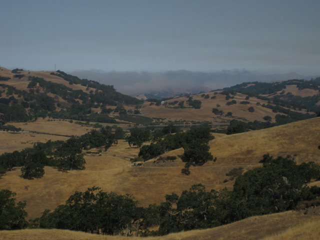
With a bit of a breeze and more strength in my legs, I found the climb less arduous than in the past. Oh, and the view! Apart from one ranch, there is no sign of civilization as far as the eye can see—unlike the other side of the hill, which overlooks the urban/suburban sprawl of the Santa Clara valley.

Back at the observatory, I ran into the same visitors again. “I could never do what you just did,” one remarked. I assured them that there was a time when I could not do it, either.

Fifty-one miles, 6,960 feet of climbing. Next time, I do believe I will venture ... just a little bit farther.

August 7, 2013

The Ruination of Bay Area Roads

Contrast between smooth pavement and coarse chip seal.
N.B. A slurry seal has since been applied to the packed gravel described in this post. While still unpleasant, these local roads are rideable again.
Why is it so difficult to maintain the roads in the Bay Area? The problem is not the weather.

Some roads that have been the mainstay of my homeward-bound commute have been rendered nearly unrideable this week.

That rocky surface in the upper half of my photo? It looks like a base layer, ready for paving—but it is not. That is the fresh road surface. The grainy surface in the lower half of my photo? That is what is left of the old, smooth surface (near the curb).

The new surface feels like packed gravel. [It is packed gravel, essentially.] It is wretched. Abominable. Appallingly bad. Pity the local residents who now endure the din from the tires on passing cars and trucks.

Does the town blindly accept the lowest bid? Are there no specifications? Why is this material being used, when the problem is well known? The coarser the rock, the longer it takes for weighty vehicles to wear it down. Lightweight bicycles, with skinny tires will never wear it down.
Smooth bicycle lane on a road outside Aix-en-Provence, France
The French understand this. I enjoyed the best road cycling surface, ever, outside Aix-en-Provence last fall.

Like the pros avoiding cobblestones in Europe, tonight I headed straight for the (smooth) gutter, next to the curb. Where feasible (and not prohibited), I chose to ride on the sidewalk. I explored some unfamiliar neighborhoods, seeking a new twist on my time-tested route that will keep me off the rocks without adding much distance.

Unfortunately, there will be no alternate route to avoid this legendary mess in a few weeks on Highway 1, on my way to San Simeon.

August 3, 2013

Four Goats

Vintage 1955 red Thunderbird convertible with hard top
Waiting for my ride buddy after sailing down Soquel-San Jose Road, I had a prime curbside view for a parade of vintage Thunderbirds. The one that pulled off into the park, I believe, dates back to the first model year (1955). Monterey Car Week is less than two weeks away.

Moss-covered trees, redwoods, ferns, and redwood sorrel.
The Pacific Coast fog machine was running full blast. We had climbed through the marine layer along the ridge, ducking patches of downpour from the redwoods, before descending into the summer coastal gloom below it. The shade was so dense in the redwood canyons that it seemed more like evening than early afternoon. Today's ride would be long, so we opted to climb four of the five designated hills (avoiding the steepest one). Having climbed up and over the Santa Cruz Mountains toward the coast, we would need our legs to carry us up and over to return home.

Two goats stick their heads through a fence to get an ear rub.
We stopped to check out some playful goats, and they returned the favor. Even though we were not there to feed them, they did not spurn us. Like many other animals, they seemed happy to have their ears rubbed. We kept our fingers away from mouths and horns. [They will chomp on anything. Anything.] They are smart enough not to catch their horns on the fence—they turned their heads sideways when they backed away.

Tree-covered hillsides, as far as the eye can see.
There is something about the view near the top of Eureka Canyon that always takes my breath away. Looking back on the forest, and seeing all the visible hillsides covered with trees, makes the whole trip worthwhile. For the day, some 70 miles and 5,205 feet of climbing. I expected to feel exhausted, but it seems that my commuting regimen has begun to pay off.

Maybe I should have climbed that fifth (steep) hill ... [Nah.]

July 29, 2013

Staying Safe

Ambulances and police officers respond to rush hour freeway traffic collision.
Last week, a raucous debate erupted on a road biking mailing list. What started it? Some close call between a cyclist and a motor vehicle. Cyclists railed about bad drivers. Drivers ranted about rude cyclists. I considered weighing in, but my comments would only have been lost in the noise. Mostly, people wanted to vent.

It's a scary world out there. How can you stay safe? Two words:
Pay attention.
Why?
People can do stupid things.
It happens. Drivers run red lights. Cyclists run red lights. Watch out for the drivers, and do not be one of those cyclists.
People can make mistakes.
I have made mistakes. You have, too. The last time I hit the pavement, two people made mistakes. I saw a colleague confidently board a shuttle bus and I chose to glide past. But she had boarded the wrong bus. Without a glance, she stepped off backward and clipped me with her enormous purse. Bam! I should not have been riding there. She should have watched where she was going.
Do not depend on the kindness of strangers.
I was stopped at a stop sign this morning, waiting for a break in traffic to turn left from a residential street onto a busier road. A driver in a pickup truck stopped, yielding the right of way to me. Would he have done the same for a car? [No.] He had the right of way, no stop sign. I imagine that he thought he was being courteous. I stayed put and waved at him politely to continue on his way. Had I pedaled forward, I risked being run down by any of the vehicles behind him. Not only did those drivers have no clue why he stopped (Planning to turn? Mechanical breakdown?), they were probably annoyed and all-too-ready to accelerate and pass him.

If you anticipate that people might do stupid things and sometimes make mistakes, you will have a safer time on the road. And instead of feeling chronically irritated, you might enjoy some pleasant surprises. Like the time a driver made a sudden U-turn in front of me, then pulled to the side of the road and rolled down his window—to apologize.

If you do have (or witness) a close call, learn from it. Is there something you might have done differently, to be safer?

Some driver made a mistake, or did something stupid, on the freeway this morning [photo above]. Two lanes blocked, multiple ambulances and police cars, a big traffic jam.
Pay attention.

July 27, 2013

Toe the Line

Moon setting behind the summit of Mt. Umunhum
Climbing up Mt. Umunhum after biking to (and from) work on the preceding three days is not a recipe for success. I struggled. I was dripping wet. At times, I walked. I admired the alignment of the setting moon with the Doppler weather station, on opposite sides of the Cube.

The good news is that they have patched most of the potholes up there. No longer is it necessary to choose your line up the hill by hunting for connected ribbons of pavement. The bad news is that when you climb as slowly as I do, you are prey. I was buzzed repeatedly by an enormous loud insect that flew circles around me. It may have been just the decoy, though; at one point I looked down and found blood trickling down the outside of my left knee. The hill hurts so bad, I never felt the bite.

My bike leaning against a tree near the "white line of death"
You can only climb so far on this road. On the upper section, new signs have appeared. 1.2 miles to the preserve boundary. A third of a mile later: 0.9 miles to the preserve boundary. [They are nothing, if not precise.] Not that you could miss the boundary: there are multiple “No Trespassing” and stop signs.

And then there is the fabled “White Line of Death.” If you take a look at some satellite imagery, you will see that there is a second white line. It is the second white line that really marks the preserve boundary; beyond it, the road crosses private land on the way to the summit.

View across the valley from the highest legal access on Mt. Umunhum
The last time I made it up here, there was a grumpy guy in a pickup truck on the “No Trespassing” side of the signs. Today, I was alone. I dared to venture the extra few yards past the signs, stopping at the first white line. The view across the valley was lovely.

Hundreds of California Gulls on the Guadalupe ReservoirThe Bay Area is presently burdened with an overpopulation of California Gulls. On my return to suburbia, I witnessed the problem firsthand: hundreds of cacophonous gulls on the Guadalupe Reservoir (and its banks). With the landfill nearby, this must be a veritable paradise for these scavengers.

As for me, there was one more hill to climb in pursuit of sustenance: the club's annual ice cream social. One scoop of Rocky Road, one scoop of Cookies 'N Cream, and lots of toppings: Heath bar crunch, rainbow sprinkles, fresh strawberries and blueberries, a chewy brownie ...

Thirty-seven miles, some 3,615 feet of steep climbing. I earned it.