June 19, 2015

Lenk im Simmental

Sometimes there is no Plan B.

Rainbow in low clouds, Leukerbad, Switzerland
Our next destination, 
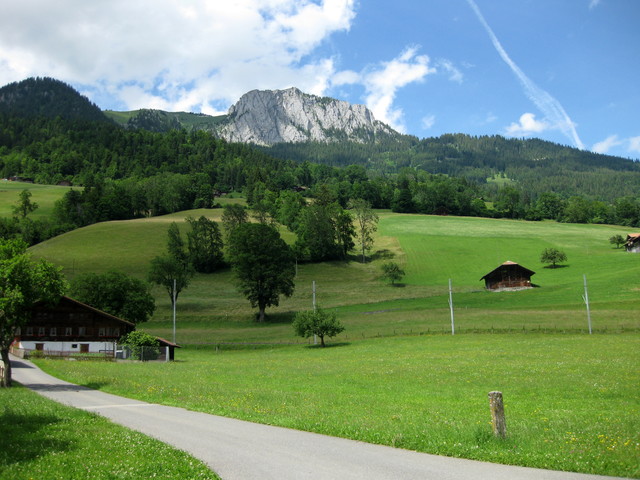
Lenk im Simmental, was on the other side of the mountains; the shortest route is actually by bicycle—about 34 miles, but with more than 5,000 feet of climbing. Our chosen path was more mellow—about 54 miles, with an estimated 3,500 feet of climbing. By car, 100 miles. By train? Complicated.

Plan A was to ride up to the Gemmipass in a cablecar with our bicycles, bike along the unpaved-but-packed trail along the ridge, and then ride another cablecar down a different slope to start our journey on the road. On a clear day, the views would be unrivaled.

So it was not good that the top of the mountain was hiding in the clouds, and less good that it was, in fact, raining.

Cycles and cyclists loaded into the Gemmi-Bahnen, Leukerbad, Switzerland
We waited a bit, perhaps for the weather to improve, perhaps while our host explored alternative options. Then we biked over to the Gemmi-Bahnen, where the operators gave us a quizzical look. Were these folks, with their road bikes, really going up in the cablecar ... in the rain? I imagine they expected us to return in short order.

Especially since they knew more about the conditions at the top than we did.

Cyclists walking bikes along the gravel path between rocks and snow, Gemmipass, Switzerland
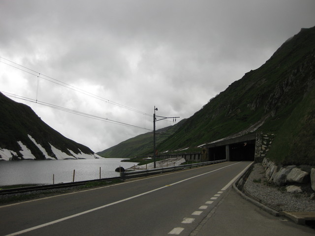
The gravel trail was mostly exposed, often single track ... through snowfields.

Cyclists traversing the gravel path next to snowbanks, Gemmipass, Switzerland
Today would be pep's introduction to mountain biking (without the mountain bike).

We knew that some of this trail would not be rideable on our bikes, and that we would hike short distances. I normally wear mountain biking shoes (with recessed cleats, and some tread) for ease of walking—indispensable, today.

Cyclist traversing snowfield along the Gemmipass, Switzerland
Apprehensive at first, hiking seemed wiser to me than biking. But biking, of course, is faster.

Tentatively, I made my way along the path. When the exposed trail was a series of large stone blocks, I guessed that we were really traversing the top of a wall; snow filled in the slope below us. I dismounted and walked; little margin for error, there.

Snow on rear brakes and wheel, Gemmipass, Switzerland
Gravel and snow and mud ... oh my! A fellow rider coached me. “Slide back off the saddle, more weight over the back wheel.” His wife darted ahead, her mountain biking skills evident.

Gravel path with rocks and flowers, Gemmipass, Switzerland
When I stopped to snap a photo near the Daubensee, one of our riders suddenly realized that he no longer had his camera. [Note to fellow aficionados: offload vacation photos from your camera's storage daily.] He backtracked, but didn't find it.

Patch of blue sky and puffy clouds along the path to the Sunnbüel cablecar, Gemmipass, Switzerland
This being Switzerland, the story of the lost camera has a happy ending. He had spoken to some hikers on the trail, who miraculously found—and forwarded—the camera. Too bad they didn't snap a photo of themselves, for posterity.

Hotel Schwarenbach exterior, Gemmipass, Switzerland
We regrouped at the Berghotel Schwarenbach, once visited by Mark Twain, where a hot cup of tea and a pastry were most welcome. When we reached the cablecar at Sunnbüel, we had traversed more than five miles along the ridge.

Gravel path continues through an open meadow with flowers, nearby peak with snow and clouds, Gemmipass, Switzerland
From the snowfields to the tropics, our next destination was the town of Frutigen, where we would meet for lunch at the Tropenhaus. “Just follow the signs,” our host told us, as he stayed back with a trailing rider.

Low clouds scattered across nearby peaks at the top of the Sunnbüel-bahn, Gemmipass, Switzerland
We rolled into town; there were no signs, we had no address, and none of us remembered the name of the place. I pulled out my smartphone. It seemed like a long shot, but what the heck. “OK, Google,” I said. “Where is the tropical restaurant in Frutigen?” Up came a listing for the place, along with the address and its location on the map. I was certain that “Frutigen” would not be understood, and here I was presented with an arrow for turn-by-turn navigation details. It's magic, essentially.

Tropical greenery at the Tropenhaus, Frutigen, Switzerland
With most of our route ahead of us, we were not eager to linger over lunch. There were some differences of opinion about the route we should follow; the shortest route entailed more climbing than any of us wanted. The group split, then came back together before two riders decided to rely on their Garmin for an alternative route.

Cyclists along a rural road, with blue skies and puffy clouds over the hills, en route to Lenk im Simmental, Switzerland
On an unpaved trail through some fields, I misjudged a patch of gravel. Deeper than I expected, it grabbed at my front wheel. I went down hard. Rattled, but only scraped, I stayed on the roads after that.

Pastoral view with distant rock face, en route to Lenk im Simmental, Switzerland
By the time I got to our hotel, I was one tired puppy. The first part of our journey on the Gemmipass took one hour and 45 minutes; the second part, on the road, five hours and 15 minutes. I can only estimate our climbing for the day, as my bike computer had decided to go on strike. Two apps running on my smartphone have reported vastly different elevation gains for the same routes throughout this trip: for example, 4,456 feet and 3,206 feet for the second part of our route. The estimate at GPSies: 3,493 feet. For the day, we biked some 54 miles.

View of green hills and distant snow-streaked peak from pep's hotel room, Lenk im Simmental, Switzerland
We checked in and got cleaned up. Besides the view, my room had a balcony complete with flowers and a fold-down rack where I hung my laundry to dry.

Sun highlights one hilltop before sunset, view from pep's hotel room, Lenk im Simmental, Switzerland
Those two riders who had gone their own way? Missing.

The call came during dinner, and our co-host left to retrieve them. Two more tired puppies.

What a day!

June 18, 2015

Furkapass


View to the east of the road climbing up the Furkapass near Realp, Switzerland
The group splintered today.

Road and snow-streaked mountains approaching the Furkapass from the east, Switzerland
One choice was to get a ride to the top of the first climb. [Unthinkable.]

Snow-streaked rock walls along the road to the Furkapass from the east, Switzerland
Another choice was to go the distance. [Perhaps a bit much, at my pace.]

Red Swiss train crossing along the valley floor near Hospental, Switzerland
The route included some flat meandering through a valley, book-ended by challenging climbs. I studied the map and the train schedule, and hatched a plan. About halfway along the route, I would hop on a train and cut out some 30 miles, disembarking in the town at the base of the climb to our hotel.

pep and bicycle at the summit of the Furkapass, alongside snow banks, Switzerland
I was on my own, for a lovely, leisurely, long climb up to the summit of the Furkapass, which tops out at 7,976 feet.

Waterfall near the road to the Furkapass, Switzerland
I could stop whenever I wanted.

Gentian flowers along the road to the Furkapass, approaching from the east, Switzerland
I could stop wherever I wanted.

Bicycle parked against a snowbank near the summit of the Furkapass, eastern side, Switzerland
I could stop as often as I wanted.

View of the hairpins on the road descending the western side of the Furkapass, Switzerland
(And I did.)

Rhône river flowing through the valley, descending western side of the Furkapass, Switzerland
But I did need to keep making forward progress.

View of the hairpins on the western side of the Furkapass from below, Switzerland
I was banking on making good time on the descent.

Stopped for a train crossing the road, near Niederwald, Switzerland
The train from Fiesch to Leuk was not direct, but I managed to do the right thing. When I saw a horde of children and bicycles waiting for the connecting train, I made a dash for a less populated bike car.

pep's bike suspended in a bike car on a Swiss train.
I was starting to roll out of the station when ... was that someone calling my name? Yes! There were two of the riders from our group, waiting for a lift to the top. It was ambiguous whether that would be by bus or our host's car and trailer, but I was having none of that.

View of Leuk from the climb to Leukerbad, Switzerland
There were more surprises in store. First, one of the riders decided to join me, having regretted that he'd bailed on the Oberalppass. Second, the route went steeply up the hill at the start. And I do mean steeply. Luckily, it mellowed out after that. Third, I wasn't expecting a 10-mile climb (but that's what it was). Clearly I didn't study the route profile.

The climb must be popular with the locals. A strong cyclist caught me on the outskirts of Leukerbad, offering a friendly Ciao! Rain started coming down hard (surprise number four), and he turned back.

Raindops on bike computer, 2,320 ft. of ascent; 2 hours, 10 minutes, 23 seconds of time; heart rate 121 bpm.
Rather a lot of cycling today. The first part of my journey was 39 miles, with some 3,583 feet of climbing; the second climb, 10 miles and 2,320 feet. In other words, 49 miles and more than 5,900 feet of climbing.

I found the hotel. Most importantly, I made it to the dinner table on time.

June 17, 2015

Schöllenen Gorge

Given today's short ride, there was time for a bonus hike (and history lesson).

Auto, pedestrian, and train passages through a tunnel at the Schöllenen Gorge, Switzerland
To begin our loop, we walked through a tunnel with passages dedicated for autos, pedestrians, and trains, located along a key route through the Alps.

Train heading over the bridge toward the tunnel, Schöllenen Gorge, Switzerland
We followed the trail for a little more than a mile, down (and back up) steps, through tunnels, and ultimately over the old bridge itself. My legs reminded me that they'd climbed nearly 7,000 feet in the past two days.

Water cascading over rocks toward the Teufelsbrücke, Schöllenen Gorge, Switzerland
The Teufelsbrücke (Devil's Bridge) spans the Schöllenen Gorge. Several bridges preceded it, the first dating back to the 13th century. It's an impressive feat of engineering. The gorge is deep, the waters of the Reuss fast-moving. How did the first people decide it was feasible to build a bridge here, and then carry through?

River Ruess flowing through the Schöllenen Gorge, Switzerland
This site saw a battle in 1799, when the Russian general Suvorov fought against the French forces of Napoleon. A monument to the Russians who lost their lives is hewn into the adjacent cliff.

Monumental cross honoring slain Russian soldiers, Schöllenen Gorge, Switzerland
At the start of our hike, we had passed an apparent bunker in the rock wall. Fortunate are we, to come in peace.

Gotthardpass

Those who skipped yesterday's climb were itching to ride. Our leader suggested a short trip up the Gotthardpass.

Gotthardreuss snakes through the valley near Hospental, Switzerland
Why not? Besides, it wasn't raining.

This was not a pre-planned route. The rest of the group was out of sight when the slowest of us reached a fork in the road. Stay on the highway, or take the old road? Looking up at the “new” road, with a long uphill tunnel and fast-moving traffic, the old road was much more enticing. Having done some research last night about the Gotthardpass, I knew there were cobblestones. The classic approach (for bicycle racers) ascends the other side of the pass—cobbles all the way. For us, merely 3 km (a little under 2 miles). Take it from me: that's plenty of cobbles.

Gotthardreuss flows alongside the cobblestones of the Strasse Vecchia, descending from the Gotthardpass, Switzerland.
The theme for today? Waterfalls and wildflowers. Oh, and snow.

Bicycle parked next to a snowbank near the summit of the Gotthardpass, Switzerland
Facing a second day of wind and cold temperatures, I regretted not bringing a Buff on this trip. [Something easily remedied later this afternoon at a shop in Andermatt.]

Lago della Piazza near the summit of the Gotthardpass, Switzerland
I was grateful to warm up with a cup of hot tea and a pastry at the top, and looked forward to a fast and smooth descent on the “new” road.

But alas, it was not to be. We followed our leader, and ... he turned onto the cobbles of the old road. Cobblestones call for staying loose on the bike. I had a bit of an over-training headache from yesterday's exertion, and ... every ... little ... jostle ... hurt.

Valley view on the return from the Gotthardpass, Switzerland
At 6,909 feet, the Gotthardpass tops out higher than the Oberalppass.

pep and bicycle at the summit of the Gotthardpass, Switzerland.
Today's divertissement (16 miles, 2,240 feet of climbing) left time for some sightseeing and shopping back in town. No regrets.

June 16, 2015

Oberalppass

Rain. Again.

I came here to ride my bicycle, not to tour the country by car. If I don't ride today, in the rain, I will miss the opportunity to climb an alpine pass. I did, after all, bring rain gear.

Looking back toward Versam along the rain-slicked road, Switzerland
I suited up. The radar map was less discouraging; today, the rain would not be constant.

Oberalpstrasse snakes through the valley above the railroad tracks, with dramatic clouds sweeping up from a distant peak, Switzerland
The Tour de Suisse is underway, and although our routes will not align with the race, the team cars were advancing to reach Flims, for the noontime start of Stage 4. On a rural road,we rounded a bend and along came a bright green car of the chief sponsor (Vaudoise) adorned with a giant cyclist on the roof in the yellow jersey kit of a race leader. The driver was enthusiastic, honking and waving at us. Later, the team cars for Cannondale-Garmin and Lampre-Merida would appear—always around a bend, faster than I could snap a photo.

This style of stacking logs was common here, but new to me. In a word: ingenious.

Ingenious V-shaped arrangement of stacked logs, Switzerland.
I encouraged the rest of the group to go ahead. I was quite the sight in my rain gear: black shoe covers, rain pants and jacket streaked with road grime; a clear shower cap covering the vents in my helmet. To keep my hands warm, I recalled this helpful hint: wear thin latex gloves layered under regular long-fingered gloves. Your hands get wet as they sweat inside that latex, but they're warm.

Aranka and pep in her rain gear outside a café in Trun, Switzerland.

Pink, purple, and white wildflowers along the rocky roadside, on the way to the Oberalppass, Switzerland.
Our co-leaders were staying dry today; I met up with them at a café, where I indulged in my favored local treat for this trip: a nut tart (my second of the day).

The long climb came late on the route. A sign confirmed that the pass was open; I paused to let a passel of Porsches have their fun. As expected, the rain let up for a spell. Wildflowers alongside the road cheered me, and ... I just kept turning the pedals.

Flowers line the slick roads, approaching a snow-streaked peak on the way to the Oberalppass.
Higher and higher I climbed, till I was higher than patches of snow. At 6,722 feet,
the pass is high enough to be included on a list of the highest paved roads in Europe (though, not the highest of the passes I've cycled). At the summit of the Oberalppass, it was not liquid water that was falling from the sky—it was sleet.

pep with bicycle at the summit of the Oberalppass, altitude 2046 meters, Switzerland
I knew there would be tunnels. This tunnel near the summit has two passageways, one for the railroad and one for autos. I was fortunate to have the tunnel to myself.

Water, snow, and twin tunnels near the top of the Oberalppass, Switzerland
And then, I was in the cloud. A real, big, mountaintop cloud. How effective was my blinking red taillight? Visibility was a few feet, nothing more. I slowed my pace to be sure I stayed on the road, hoping for the best as I negotiated the switchbacks down the other side of the mountain.

Where was I? How much farther did I need to go? On a clear day, I would have seen the town and the valley below. Today, I could only hope that I was still heading in the right direction.

Eventually I dropped low enough on the mountain to see the valley, and a town. Surely, that must be Andermatt? (It was.)

Buildings line a channel flowing with rushing waters, Andermatt, Switzerland
The view from my hotel room could not have been more charming.

View from my hotel room, through lace curtains, Andermatt, Switzerland
A day to stand tall: only three of us did the climb—the rest bailed out and boarded a train. For me, 47 miles with 4,700 feet of climbing.