July 15, 2024

Share the Trail

We often visit Almaden Quicksilver County Park. The location is convenient for many of the folks in our group, and we have a couple of reliable, not-too-strenuous hiking loops.

As the hot spell continues, we've roused ourselves for an earlier start (to be done before we bake).

Last week, on our most familiar loop, a hiker ahead of us alerted us to a coyote. A woman behind us was pushing a small dog in a stroller, and we were all concerned for their welfare. Circle the wagons. A few us hung back to form a group with her.
The coyote showed no interest, trotting through the tall grass in search of proper prey.

We hiked a different (longer) loop this week, and a surprise was in store near the end.

An animal merged onto the trail ahead of our group. From a distance, I guessed “coyote” ... it had pointy ears, but didn't have a bushy tail. Then I saw it walk like a cat: bobcat! It stayed on the trail, periodically turning to look at us.

This is a nice trail, why not use it? Those two-legged creatures are keeping their distance. Maybe they're stalking me, but I could easily outrun them.

July 13, 2024

Cruising Up the Canyon

One of the advantages of cycling with a bike club was learning about lots of interesting places to ride (and more motivation to ride them). Now that I'm mostly cycling on my own, it's been easy to fall into a bit of a rut, cycling along a small set of familiar, comfortable routes.

But an advantage of cycling on my own is the freedom to start pedaling when it's convenient for me, rather than conforming to a club's calendar. Today I reminded myself that I was perfectly capable of biking up Stevens Canyon on my own. [And that's what I did.]

I knew it would be shady and cool along the creek, and that there would be other cyclists on the road. [Surprisingly, not many.]

On the weekends, this quiet (dead-end) road has been getting an inordinate amount of traffic. High-speed traffic. Thanks to construction on Highway 9 (ongoing for a couple of years, now), drivers learned a bypass from Stevens Canyon onto Redwood Gulch Road. I haven't climbed that super-steep road in years, and I certainly wouldn't do it now (on a weekend).

A young woman wearing a face mask, on an electric bicycle, was clearly uncomfortable on the road; she pulled over and stopped when there was a car behind her. I passed her and reached the end of the road long before she did, despite stopping to watch some butterflies (woodland skippers) on the aptly-named butterfly bush.

I imagine her partner thought this would be a pleasant, non-threatening ride for her—and maybe it was, once she got past the intersection at Redwood Gulch. I took off before they did, mindful that she would likely not be comfortable descending through the canyon at speed.

I considered a couple of options for my return route, settling on one that involved the least amount of climbing. I did, however, include one (short) gratuitous hill in both directions, because ... why not. Forty-one miles and some 2,000 feet of elevation gain for the day. [And sore legs.]

July 12, 2024

The Places You Go

Three minutes into the ride, I was sweating. I should have gotten an earlier start, although it wasn't even 9:30 a.m. Should I just turn around and go home? [Nah.]

I wanted to reach Almaden Reservoir; maybe I should just aim for the Hacienda entrance at Almaden Quicksilver Park and skip the climb to the dam. [Nah.]

There was a hint of a breeze, in addition to my self-generated airflow. It's hottest when you stop and the sun is beating down on you. [So don't stop.]
Keep pedaling, past the reservoir, past the intersection with Hicks Road, into the welcome shade of the trees along Herbert Creek.
I stopped to admire the view as I returned and watched a bunch of dragonflies zooming near the water's edge. Good luck getting a photo, I thought; they're zipping along, scooping up their prey. But I got lucky—one took a break and perched nearby (a widow skimmer, I learned). I'd never seen one of those before!

Should I stop for lunch on the way home? The price to pay would be more riding in hotter conditions. [Worth it, I decided.]

After 32 miles and a modest 800 feet of elevation gain, I wasn't feeling too bad when I rolled in—and found the thermometer registering 99°F. (Yikes!) Maybe the food helped?

Or maybe it was thanks to another happy day going places on a bicycle.

June 29, 2024

Giro Bello

Waiting for my chief cycling buddy to roll into the rest stop, I eavesdropped on a conversation nearby. One of the ride ambassadors (people who cycle along the course to assist others or summon help) was recounting his battery-related woes. Riding without route navigation because his bike computer hadn't been fully charged and ran out of juice. Stuck riding in one (challenging) gear because he forgot to charge the battery powering his electronic shifters, which ran out of juice. The other guy suggested that he should let the air out of his tires for a real challenge.

Ha, I resemble that remark. [Unintentionally.]

I'd heard the distinctive hiss of a rapidly deflating tire. I hadn't ridden through any (visible) debris. My front tire looked fine. I neglected to check the rear. Why was I working so hard yet going so slow? Lack of fuel? Lack of fitness? [Spoiler alert: a tiny wire fragment.]

I hung my bike on a rack at the lunch stop, and for no particular reason, squeezed the rear tire. It was utterly flat. Looking at my ride stats, I plodded along on that deflated tire for about two miles. No one else had noticed, either—I'm sure they would have said something.

I couldn't budge the quick-release lever, which was way too tight after I'd had the bike serviced recently. Spare tube in hand, I rolled the bike over to the mechanic's tent, grateful that I wouldn't have to struggle to replace the tube. “No problem,” he said. “Get your lunch, and keep your spare tube; I have tubes.” Ah, the perks of a supported ride!

Many organizations host bike events to raise funds for charitable causes, big and small. Today's was run by the Rotary Club of Santa Rosa, with routes similar to the Wine Country Century. [But on a much smaller scale.]

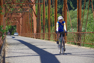
There are a few iconic, must-stop photo ops along this route. That barn. The Wohler Bridge over the Russian River.
I first crossed this bridge in 2003 on day two of Waves to Wine, raising funds to support the work of the National MS Society. I've crossed it many times since, almost always capturing a shot of my bike on the bridge. Now I have an action photo!
I'd chosen to wear my favorite Waves to Wine jersey, the one that invariably gets questions from other riders. Yes, Waves to Wine still happens (in September), though sadly this scenic route is no longer a part of it.

Such a nice ride, on a beautiful day—giro bello! Sixty-six miles and about 3,000 feet of climbing up and down the back roads of Sonoma County.

June 27, 2024

Get Thee to a Rookery

The route I regularly use to bring friends to the rookery was not ideal for my weekly riding companions. I mapped out a shorter, pavement-only alternative, and today we took it for a spin.

I'd explained that binoculars weren't really needed, which they understood once we rolled in.

My feathered friends did not disappoint, though for the first time in so many visits a flying egret nailed me on the shoulder (splat)! (Hit one of my buddies, too.)

The birds have been nesting in this area for many years (decades?), despite the trees being surrounded by office buildings (currently, a Google campus). They're accustomed to coexisting with people: workers strolling from one building to another, birders equipped with serious camera gear, and ordinary gawkers like us. By not interfering with them, we are privileged to observe them at close range. Snowy egrets feeding chicks, fledglings testing their wings, well-camouflaged juvenile black-crowned night herons eyeing us through the branches.

Once I'd settled on where we'd start the ride, the rest was easy: I had honed much of the route through so many bike-commutes over the years. Although some of today's route didn't exist when I'd needed it, I found one stretch through a neighborhood that I should have discovered long ago. [Will use again.]

We paused for pastries (of course!) on our way back to the park where we'd started; from there I pedaled home, giving me a healthy 42 miles and some 1,400 feet of elevation gain for the day.

Next order of business: wash that jersey!

June 24, 2024

Revisiting Saratoga Gap

The weather was warm, several key folks from our group were traveling, and it seemed clear there would be no hike today unless I organized one. [So I did.]

How about ... something “new” to this group, outside the regular rotation. Something shady. [Or, mostly so.]

Saratoga Gap! A few months ago, my former teammates introduced me to a loop that could fit the bill today.

Success! Three people came along and enjoyed the route, which was definitely more peaceful on a weekday. Consensus: “Would do again!”

A fairly easy hike, we covered 4.6 miles at a good pace, finishing with plenty of time for everyone to continue on to their afternoon commitments.

When I got home, I was surprised at how sweaty I was. Wait, I know this feeling: it's humid! Remnants of a tropical storm brushed the Bay Area, even delivering a thunderclap and brief downpour. (Luckily, not enough to soak the hiking boots I'd left outside to dry.)

June 22, 2024

A Training Ride

Rather by accident, last year I learned about a three-day fundraising ride that's been taking place annually for more than 25 years. (So of course, I signed up.)

Today was the first “training ride,” and since I'm a newcomer to this event I figured I ought to show up. This would also give me a chance to gauge myself relative to some of the other riders.

The ride started in Aptos, entailing an early morning for me to get there. The coastal fog was a plus (and I was properly dressed for it). Truth be told, I was not looking forward to driving back to the hot valley later; but loitering in the coolness would mean enduring the miserable summer weekend traffic jam to get home.

The ride leader was casual about the route, having mapped it using only Google Maps. [From that, I'd created my own copy on RideWithGPS. Just in case.] Our group was small (five, plus the leader) and familiar with the area. The plan was to ride ~17 miles, with an option to extend the route depending on who showed up. We passed muster en route and agreed to the longer version. (Last year, apparently, someone showed up in shorts and sandals.)

The group? A fit-looking woman who said she hadn't been on a bike since November. A young woman (visiting) on a borrowed bike with flat pedals. An older guy who knows he can't ride like he used to. [I so wanted to show him how to adjust his helmet straps properly. It's a thing I do. But I forced myself to stand down, these people knew one another and might not welcome unsolicited advice from a newcomer.]

Some of the route was familiar to me: we passed the road that leads to the first rest stop for Strawberry Fields Forever. We rode through Manresa State Beach, my second (and last) camping experience. Our extension took us to Sunset State Beach (which I had never visited, until now).

For a first training ride, I expected something simple. Something easy. I wasn't expecting about 1,600 feet of elevation gain over 24 miles.

I was humbled. I started out with the front of the pack; as we returned, I was fully off the back.

Time to get serious.