After riding down the Pacific Coast
ten times for
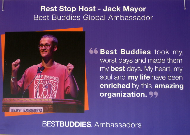
Best Buddies in the
Hearst Castle Challenge, this year would be different.
That view never gets old, so why change the route?
Mother Nature, that's why. Last winter's storms first undermined a bridge over Pfeiffer Canyon; and then, as if knocking out a bridge wasn't enough, a massive chunk of hill slid down onto Highway 1 at Mud Creek. The road repairs may not be complete by this time next year.
Our destination (Hearst Castle) is a constant, but ... you can't get there from here. The ride must go on, and thus Plan B was hatched. All routes would start (as well as finish) in San Simeon, at
Hearst Memorial Beach, instead of the traditional start in Carmel Valley.
I struggled mightily over which route to pick. Forego the 100 mile route and opt for the 100 km route instead? Yes? A more scenic climb up Old Creek Road (vs. Highway 41). No! I've
always done the century; if I skipped this year, I wouldn't know whether I
could have done it. Either way, late in the route (mile 37, or mile 78) I'd face a steep climb on Santa Rosa Creek Road. (Going rogue, following Highway 46 all the way to the coast, did cross my mind.)
But I stayed the course.
All 101 miles of it. From San Simeon, through Cayucas, to Morro Bay.
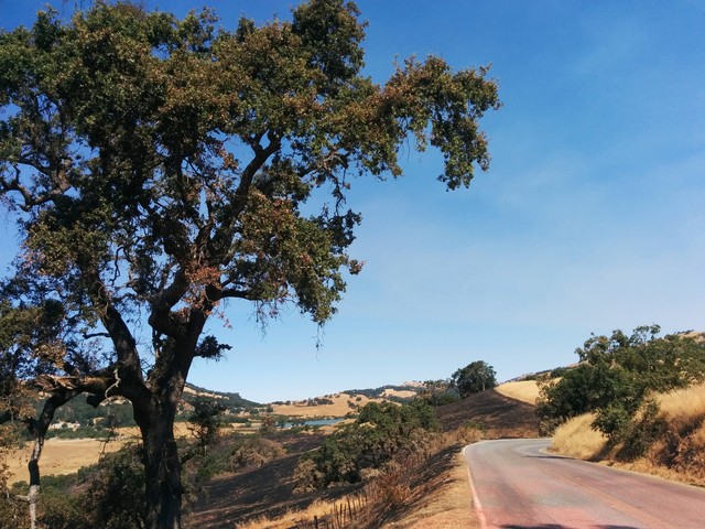
Up Highway 41, into the
Los Padres National Forest, to Templeton.
In keeping with this year's track record, my level of training was not where I needed it to be. A record-breaking heat wave, enhanced by bad air (from distant wildfires), kept me mostly off the bike over the preceding ten days.
The sun broke through and started baking us as we climbed inland; I started feeling a bit twitchy around mile 60; a bit of bonk was creeping up on me. [Uh oh.]
We would be tackling Santa Rosa Creek Road in the downhill direction, descending the wicked wall. I'd wager that a handful of participants (at best) had ridden this road before, in either direction. The climb from Highway 46 starts out gently. I knew it had to get steep, recalling my
wild ride last year. “Is this the climb?” a nearby rider asked, clearly not impressed. “No, it gets steep.” (He thought an earlier climb today was steep.) “No no no, this gets
steep.”
A rider walking up the hill came into view. It didn't look all that bad.
And it probably wasn't all that bad, at that point. But with 78 miles and more than 4,300 feet of climbing behind me, my legs simply gave out. For the first time, I considered what it might be like for pro riders in Grand Tours to finish a long stage at the top of a mountain. Sure, I've pedaled up some of those climbs. But not with 100+ miles in my legs. (By the way, our peloton today included
Big George and
Christian Vande Velde, so there just might be a new KOM on Strava's leaderboard.)
The pavement is in terrible condition, making the technical descent to the coast even more tricky. There were occasional signs cautioning “Rough Road,” but it would have been more honest to mark the few sections of smooth pavement, instead. The ever-vigilant Best Buddies staff must have emptied a full can of purple paint marking the cracks and potholes. In a couple of places, they had consistently sprayed “Very Steep Decent,” which made me laugh. There's nothing decent about a steep road.
There was no warning about the loose dog. He turned to face me, and of course decided to give chase. Having expected that, I dug deep and sprinted, hoping to outrun him. [I did.]
There was no warning about the loose head of cattle, either. He was walking up the road and bellowing. I slowed, glad that it wasn't one of the longhorns I'd seen earlier, but unsure how he'd react. He moved to the opposite side of the road, focusing on the herd on the other side of the fence and bellowing mournfully. [Whew.]
There were no bikes at the rest stop at the base of the road (even though I'm slow, that was a first). I knew there were riders behind me, and I knew that most of them would not have an easy time coming down the hill. Of course, they might have given up and hopped in a SAG wagon, but that didn't occur to me. [They hadn't.]
The next challenge was heading north on Highway 1. The name of that challenge was “Headwind”—payback for 10 years of tailwind. This year, we had a crew of domestiques (!), outfitted in yellow jerseys emblazoned with “Get on my wheel!” My guy pulled me for a few miles before swinging off to wait for others, and I relished every inch of that draft.
Mother Nature had one more surprise for us: Hurricane Irma. [Say what? We're in California.] This year's entertainment at the post-ride barbecue was to have been KC and the Sunshine Band ... but they were stuck in Florida. At the last minute, the organizers pulled an LA-based band out of a hat—Soulville California Band. And the dance floor was packed!
My internal soundtrack during the ride was the Hollies:
The road is long
With many a winding turn
That leads us to who knows where
Who knows where
But I'm strong ...
I love this charity, and I keep coming back—for the Buddies.
He ain't heavy, he's my brother.