September 1, 2011

Grosio

Having enjoyed perfect weather so far, no one was complaining about a few raindrops on a day when we were all ready for a rest.

Rest, of course, does not mean lounging about the hotel reading a book—not with this crowd. After breakfast, I set out with a small group hiking to Grosio, where we explored the remains of a medieval castle and then searched (in vain) for traces of the Iron and Bronze Age-era carvings on an adjacent rock outcropping in the Parco Incisioni Rupestri di Grosio. There are some 5,000 carvings on this boulder and we could not find a single one. Not surprising, then, that they were not discovered until the 1960s.

As the rain began to pelt us, I was reminded that I had neglected to pack an umbrella for this trip. We headed for town and took shelter in a café.

Returning to the site of the carvings, we found the adjacent museum now staffed by an amiable young man who spoke English fluently. He grew up in the area and assured us that he had not been able to spot the carvings either, until he learned where to look. Afternoon light is preferable.

The best vantage points are on the rock itself; to get close, you shed your shoes and scramble over the boulder in your socks (or bare feet). [This sort of experience would be inconceivable back in the litigious US of A.] In the flat light, visibility was somewhat enhanced now that the rock was wet: warriors, dancing figures, animals, a rake (early testament to the importance of agriculture). Once you know where, and how, to look.

August 31, 2011

Passo dello Stelvio

In signing up for this tour, I was at last fulfilling a dream to cycle in Europe. When I realized that I might have a chance to climb the legendary Stelvio Pass, I was thrilled. Now, I sincerely hoped that I had not burned out my legs on the Mortirolo loop.

It would be straightforward for us to approach the summit from Bormio; while I am sure that would be beautiful, the classic approach is from Prato allo Stelvio. The logistics would be a burden, but our host made it happen. He dispatched a few strong riders to tackle the climb yesterday, reducing the size of our group to fit into two vehicles laden with bicycles today.

We drove through Bormio and up to the summit of the Umbrail Pass. There, we bundled up and descended to the valley, passing through the town of Santa Maria (Switzerland) and looping back into Italy to start the famous climb from Prato allo Stelvio.

Ever the laggard going uphill, my plan was to descend as rapidly as possible to get ahead of the group before we started to ascend. We were warned to expect one unpaved section of road (a mile of packed gravel) on the way down. I was especially cautious there; one rider caught and passed me, but nonetheless I was the first to reach the valley. [Not having seen me descend until now, my fellow riders were surprised. "You were en pointe, the whole way down!" Nice way to put it. I smiled.]

At the border, the Italians waved us through, and I booked it all the way to Prato—where I promptly headed in the wrong direction. Having stopped for a bio break, I was separated from the rest of the pack and never saw the last sign toward the pass. (Evidently it was easy to miss, being somewhat obscured by a tree.) I approached a couple of guys in a parking lot, and they happily sent me in the right direction.

More than any other climb on this trip, I wanted to complete this one. I started going up; my legs felt surprisingly strong! I began to believe that I could do it. I have certainly done more climbing in a day than this would require, but not over such a short distance.

There are 48 switchbacks on the way to the top, and each turn is numbered. I rounded switchback number 48 after about 4 miles. Warmed by the effort, I had already peeled off my outer layer. Up to that point, the average grade was 6%; almost eleven miles remained, with an average grade of 7.9%.

The road is carefully maintained, smooth pavement swept clear of gravel and rocks. I quickly found a source of acceleration in taking the right line through each hairpin—every little bit of energy helps. About two thirds of the way up, the Berghotel Franzenshöhe serves the best apple strudel imaginable—my single portion filled a dinner-sized plate and sustained me over the rest of the climb.

Many cyclists passed me along the way, but as I drew nearer to the summit, it was my turn to pass. Endurance, I have. I am sure the diminishing concentration of oxygen slowed me further, but I reached 8,300 feet before I noticed. Painted marks on the road counted down the distance remaining: 6k ... 5k ... At hairpin number 1, I lingered in a state of awe.

There is quite a festival at the top of the Stelvio Pass: food, souvenirs, proud and exhausted cyclists, and plenty of tourists.


I traveled 38 miles by bike, climbing 6,040 feet along the way—virtually all of that climbing was packed into the last 15 miles. I am stunned to say this: It felt great! Which means, of course, that I should have ridden at a faster pace.

Next time ...

August 30, 2011

Bormio

On the menu for today was a climb to a lake. To make that feasible, our host arranged to shuttle riders forward in two groups. I landed in the group that would start cycling from our home base in Grosotto.

I was apprehensive about this ride; not only would it be my third consecutive day of cycling, I expected to pay for yesterday's excesses.

The group took off at a brisk pace, and of course, we started the gradual uphill journey almost immediately. Despite dropping down to my lowest gear, my legs were screaming and my hands were going numb (a new phenomenon, for me). By the time we reached our shuttle rendezvous point, we had climbed 880 feet over less than six miles.

I was not the only rider who was keen for a recovery day. When our host disgorged us near the base of the climb to the lake, all but two riders rebelled and opted for a simple ride back to our home base. We created our own adventure, finding our way to a café in the oldest section of Bormio. We visited a local bike shop, where we secured advice on following the bike path back to Grosotto. After sensing some uncertainty in our group about the route, I reconfirmed the plan with one of the shop's mechanics. A picture—in this case, a Google Map on my phone—was worth a thousand words (in any language). After yesterday, I was not so ready to cede navigational responsibility to anyone else.

The sky was threatening rain, but we made it back without incident and in time for lunch.

Our return route might seem downhill (on paper), yet we ended the day having ridden a respectable 27 miles and climbed 1,525 feet. Would my legs be fresh enough for tomorrow's queen stage?

August 29, 2011

Passo di Mortirolo

Heading out with the first riders was a lucky choice today, as we did not follow the traditional Giro d'Italia route to the summit of the Mortirolo. [Those who did, were humbled.] The climb from Grosio was not difficult; I paced myself, expecting the grade to worsen before I reached the top.

Approaching the summit, I was encouraged by the names still visible on the road (Basso, Nibali) and heralded by a cacophony of cowbells (on cows, of course). By the time I arrived, our group had split for lunch or to return to the start. Fortunately, I was able to hand my camera to a touring motorcyclist who paused for a break.

After lunch, my day went south—in both senses. Some miscommunication separated me from the group: I returned to the summit, hoping for some better photos, while the others thought I had gone ahead. I crossed paths with a few when I did start to descend, as they had been delayed by the Guardia di Finanza at the restaurant. [From what they gathered, the establishment was in trouble for not issuing receipts—and they had overcharged us. The tax men must have been expecting this, because they pounced as the last of our group were about to leave.]

I was not prepared to exercise my orienteering skills on this trip, and I failed to study the GPS track on my phone to understand where we were. Instead, I considered myself lucky to have synced up with the one fellow rider who spoke some Italian.

When we came to a fork in the road, we misplaced ourselves on the map. A sign pointed left, downhill, toward Doverio; the fork to the right had no sign and headed slightly uphill, which we did not expect. There was an arrow painted on the road, labeled "G F Pantani," pointing toward the uphill fork. It turns out that my reading was correct—Gran Fondo Pantani—and we should have followed that.

The key point, I now believe, is that the lack of a sign is a valuable clue: namely, that you are still on the main road and should keep following it.

We dropped down a steep set of switchbacks to Doverio, leading to an excursion along a highway (SS39) and adding an unwelcome climb up a minor pass. It also reinforced a surprising discovery about Italian motorists: They have tremendous respect for cyclists. Throughout the trip, it was rare for a vehicle to pass too closely. If there is not enough room to give us a wide berth, the driver waits. For their part, cyclists strive to travel in small bunches, leaving gaps that allow vehicles to leap-frog forward.

We passed through the town of Aprica and descended to Stazzona, at which point we found our way back to the intended route (more or less). I was oh-so-relieved when our home base, Grosotto, was in sight. After covering an unintended distance of 50 miles and climbing 6,600 feet, I was emotionally and physically spent.

And then, in an instant, I was restored: A passing motorcyclist, approaching in the opposite direction, waved and blew me a kiss! Grazie, signore; you made my day.

August 28, 2011

Eita

As we rolled northeast out of Grosotto, my eyes were immediately drawn to a small town on the hillside above us. While the valley and surrounding slopes were still deep in shadow, the rays of the sun fell on that cluster of buildings like a spotlight. Naturally, that is why they were built there.

Soon, we were passing through that very town—having entered neighboring Grosio, we hung a left and immediately started climbing.

As the road snaked ever upward, through fields and hamlets, I began to wonder about ... food. We were heading for the town of Eita, and I had no clue how far we would ride before we reached it. I regretted not bringing along a PowerBar. Just then, I rounded a bend into Fusino, and lo—the rest of our group had already invaded the café, and we soon found ourselves sharing a pie-sized chocolate tart.

One of my friends emerged from the toiletta. "Good luck with that," she said, as I stared down at the porcelain fixture in the floor. There is book knowledge, and there is empirical knowledge. [N.B. see Going Abroad].

Much relieved and refueled, I happily resumed our climb. Cowbells (attached to actual cows) greeted us at the summit, along with a splendid source of water. Our group split up, with some of us venturing a bit farther down the road. In this, we were well-rewarded.

We enjoyed an unforgettable lunch at Baita Franzini, where the experience was more like sharing a family meal than dining at a restaurant. Potatoes (boiled, then fried), stew (with local mushrooms), polenta, game (wild mountain goat), cheese, apple fritters, fresh fruit. Homemade wine shared in a 100-year old communal wooden bowl. Conversation ranged from Hurricane Irene (they offered to let us watch coverage on TV), to politics (Berlusconi), to cycling (of course). On Pantani: "God gave him a big heart and big lungs, but no brain!"

My first day of cycling in Italy. Beautiful route, 24 miles, 3,695 feet of climbing. Everything I had hoped for, and more.

August 27, 2011

Grosotto

My first few days in Italy were the appetizer; now it was time for the main course.

Returning the rental car was the most angst-inducing bit of driving yet. The garage was jammed, the spaces were tight, and cars were left in the driving lane. In true Italian style, someone flipped my passenger-side mirror back so I could squeeze through an opening that looked impossible. After driving 515 km without incident, was I destined to scrape the vehicle in the last 10 meters?

Next, I hauled myself and my baggage (remember that bicycle?) out to the bus that would take me to Bologna Centrale. One of the nuances of Italian train travel is the requirement to validate your ticket before boarding the train. Without prior research, this fine point would have escaped me. The high-speed train arrived in Milan in less than an hour. Needless to say, I collected some data: we averaged about 141 mph, with a top speed in excess of 162 mph.

At Milano Centrale, the ticket validating machine next to my train was non-functional. An Italian standing nearby launched into some lengthy exposition and did not stop even when I offered Non parlo l'italiano. I followed the lead of a fellow passenger and used the machine at an adjacent track.

The train ride to Tirano was neither high-speed, nor express. And that was just fine, as there was much to see along the way.

My final destination was the tiny, charming town of Grosotto. No longer a solo traveler, I would join our group for the start of our cycling adventures in the Italian Alps. We were staying at a "bike hotel," which caters to the needs of cyclists.

The Pika Packworks bag lived up to its reputation: lightweight enough to carry around, sufficient protection that the bicycle arrived unscathed. Reassembly went quickly and smoothly.

At last, ready to ride!

August 26, 2011

Bologna

Driving in Italian cities is a tricky proposition. Streets are narrow, zones can be restricted, and the locals seemingly engage in creative driving as a sport. The hotel advised parking near the train station; I researched garages in the vicinity and used the navigation function on my now-enabled cell phone to home in on my destination.

Bologna Centrale is a major hub, and the station was bustling. There were a couple of unsavory-looking young men loitering about, but they were outnumbered by officers in uniform. It was straightforward to buy a ticket from the automated machine and bypass the line at the ticket counter. After scouting the platforms, I started to believe that I could board the right train tomorrow.

I stepped out of the station just as an open-air tour bus pulled up. Brilliant! Plug in the earphones and tune the channel to your native language. The tour oriented me to the city and its sights; by the time it was done, I had enough confidence to explore it on foot. Most businesses close for a few hours at mid-day; I enjoyed a sandwich and cooled down with a new discovery, granita.

Bologna is not a top destination for foreign tourists. I knew I had blended well when some young Communists tried to hand me their leaflets.

There are some 23 miles of porticos throughout the city; back in the day, they were required on all buildings. They knew what they were doing—today they provided welcome relief from the hot summer sun. I learned that Bologna is the birthplace of Nobel prize winner Marconi (wireless telegraphy), and home to the oldest (still operating) university in Europe (dating back to the 11th century). I was startled to realize that I had passed through a section of the train station that was the site of a fatal bombing in 1980.

Next on my agenda was Post Italiane. The drill at the main post office would be familiar to anyone who has visited the California DMV: determine the right category for the service you need and take a number. I presented the clerk with three identical postcards addressed to the USA. He carefully weighed each and every one of them (!) and affixed the requisite postage.

How do the Bolognese regard their city, I wonder? With its mixture of old and new, do the antiquities become a nuisance? Crumbling medieval walls, a leaning tower, monuments, fountains. Daily life flows around all of it, with hardly a second glance.

August 25, 2011

Sant'Agata Bolognese

The television in the hotel's breakfast area was tuned to the news. No knowledge of Italian was needed to interpret the images: Libyan rebels had breached Qaddafi's compound. Footage of the gaudy and opulent trappings flashed by, including a mural inexplicably depicting a familiar Silicon Valley name (nVidia) [huh?] and ... a yellow Lamborghini. How ironic.

Courtesy of the free wi-fi at the hotel, I scouted out a place to recharge my SIM card and embarked on the next leg of my journey. What looked straightforward on the map was much less so once I was behind the wheel, piloting through a warren of narrow streets with few signs. Lost again in the urban fringe of Milano, I found a parking space near a busy café, and bravely took my place in line at an adjacent shop.
Buon giorno ... ricarica ... Wind ... venti ... per favore?
I successfully traded 20€ for two scratch-off cards to restore service to my SIM card.

The second time I dialed in and listened to the pre-recorded message, it started to make sense. First, some sort of advertisement for services. Next, a typical phone tree, where option sei sounded like the way to change the language. From there, option due switched to English.

Wind started sending me SMS messages. In Italian, of course. It would still be a while before my data service went live; eventually I puzzled out that one of the SMS messages asked me to text a message back to confirm my service activation, and that I needed to restart the phone.

Being somewhat anxious about soloing my way around Italy for the first few days, I had brought along point-to-point Google Maps directions (just in case). Back on the autostrade, I stopped at a service area for a sandwich that was a world apart from anything you would find along, say, the New Jersey Turnpike.

Having missed the appropriate exit [Modena Sud], I was forced to continue most of the way to Bologna before I could turn back. Rather than checking into the hotel first, it seemed most prudent to head directly to my next destination. This would allow ample time to find it, as I predicted (correctly) that I would get lost in the process.

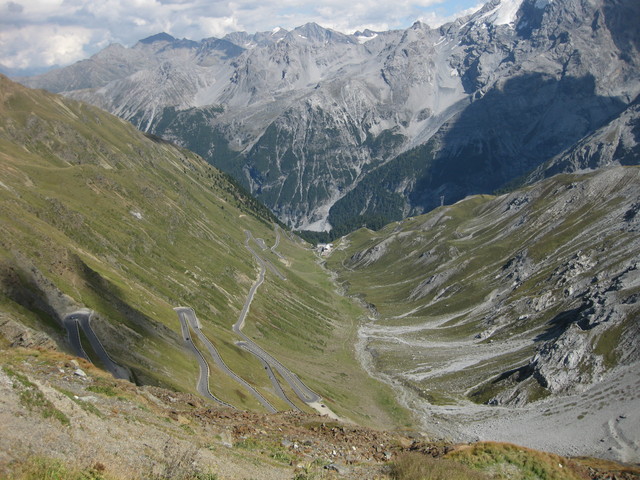
A few more observations about driving in Italy: If there are no lines painted on the road, drivers will squeeze as many cars into the space as possible. Doing 70 kph on rural one-lane roads signed for 50 kph, drivers sped past me and zigzagged around the oncoming farm machinery. On the outskirts of town, I saw my first electronic speed sign, which might seem surprising for a town as small as Sant'Agata Bolognese.

Or not surprising at all, if you understand that this is the home of Lamborghini.

I had plenty of time to wander through the museum before my escort arrived. After stowing my bag in a locker (no photos, of course!), the doors to the courtyard were thrown open and my personal tour of the factory was underway.

New cars, in every color, filled the courtyard. Inside, I was guided along every station on both manufacturing lines (Gallardo and Aventador). Engines being built, lowered into a car, and tested. A windshield lowered carefully into place by two men, and then withdrawn to correct some small problem. Test stations. Final inspection. A separate area, where the cowhides are marked so that no flawed section will be used. Leather being guided by hand and eye through an ordinary sewing machine to add the razor-straight lines that flank each seam.

If you have seen the finished product up close, it all makes sense. Passion, and attention to detail, in abundance.

August 24, 2011

The Adventure Begins

What kind of sports equipment? Is it ... a bicycle?
The Lufthansa agent did not hold my attempt to dodge the $200 bike fee against me. She switched me from a middle seat to an aisle, in a center row with just one other passenger. Consequently, I was able to curl up (more or less) comfortably across two seats and sleep through much of the long flight. There are some advantages to being small.

My first language encounter came before I even took my seat, as an older gentleman stepped aside for me. Prego, he said. Grazie, I replied (more or less). Like most Americans, I am fluent only in English.

I was seated behind an Italian family with two young boys, and one of them (watching cartoons) delighted me with the purest laugh I have ever heard. In the rearmost section of the cabin, it was easy to forget the enormity of an Airbus 380 (more than 600 passengers on board, and yet some seats were empty). Luckily, I failed to discover the three cameras mounted on the jet's exterior until the flight was nearly over [else, I would not have gotten the sleep I needed].

In Frankfurt, I chuckled at a fellow countryman who balked at forking over $10 for his sandwich at the airport, and began to feel less ignorant for having successfully coaxed some euros from a Deutsche Bank ATM.

In Milano, I was overjoyed to collect mia bicicletta (though the guy at the oversized baggage door was happy to exercise his English). I must have been quite the sight: a tiny gray-haired signorina with a backpack, tiny rolling suitcase, and a huge bag—almost as big as she is—slung cross-wise over her shoulders.

Next hurdle: renting a car and then ... driving it. The rear seats in my (pre-dented) Citroën C3 folded down, my bags fit, and off I went. The clerks at Auto Europa were friendly and helpful, and likely highly amused at the tiny gray-haired American signorina (see above), traveling alone, who rented a car with a manual transmission. Trust me, this is not something they see every day.

I headed for the autostrade to find my hotel on the outskirts of the city. My strategy: fall in line with the traffic in the right lane, decipher the road signs, and try to stay out of trouble. First observation: Italian truck drivers change lanes whenever they please, give them plenty of space. There were no attended lanes when I reached the toll booths at my exit; I managed to pay without irritating any drivers behind me. [Whew.]

The hotel, on a major thoroughfare, was clean and economical. Next to a bar, a pizzeria, and an adult store—not the best part of town. I failed at my next two challenges: finding a place to recharge the Italian SIM card I had acquired in advance, to get data service on my phone; and finding dinner. No data service = no Google Maps. No Google Maps = no Navigation. After driving more or less in circles for an hour or so on my quest, I did manage to find my hotel again. The nearest restaurant was closed: summer holidays.

Thus begins the story of my first solo international trip.

August 20, 2011

Summertime

And the trees are dripping.

When the wind woke me this morning, slapping the blinds against the window frame, I knew. Such turbulence is a sure sign of a dense marine layer whipping over the Santa Cruz Mountains, and that is where our ride was headed. Time to bundle up.

As we climbed, the windshield wipers of approaching vehicles were running intermittently. For the droplets on my glasses, there was no such amenity. On the edges, the fog roils like steam rising from a pot of boiling water. [Except, of course, that the fog is cold.] In the midst of it, tiny droplets prick your face and ping off your jacket. In the thick of it, big drops condense from the towering trees and pelt you like rain.

There was little point to the sunscreen I applied, out of habit. The occasional fuzzy shadow cast by the weak light was an ironic contrast to the sharp contours I saw by the light of last weekend's full moon, deep in an isolated valley.

It was a beautiful ride nonetheless, despite wishing for long-fingered gloves and toe covers. Thirty-eight miles with about 3100 feet of climbing—the incentive, to stay warm.

August 14, 2011

Over Hill and Cloverdale

When I heard the locals remarking about the weather—sunshine is not normal at 9:15 a.m.—I knew we were in for a splendid day. One reward for arriving well in advance of our planned start time was a warm cinnamon roll at the country market. Other rewards included watching a doe and her fawn wander through town, and one much-beloved dog enjoying his trip on an ATV.

Riding for the third consecutive day (why not?), I soon found myself out in front of the group. We came together again for a lunch break, but my schedule for the day left little room to dawdle. Now and again, there is a story that needs few words. This is one of those.

A field of flowers along the Butano Cut-Off.


Cloverdale Road, from a summit.


Gazos Creek spills into the Pacific Ocean.


The lighthouse at Pigeon Point.


A route of stunning beauty, just under 50 miles with 3200 feet of climbing.

August 13, 2011

End of the Line

And now for something completely different: Today, I descended a hill more slowly than I climbed it. [Okay, I might be exaggerating ... but only slightly.]

How is this possible? Two words: chip seal.

Normally, I descend Wrights Station Road conservatively. It is steep, the pavement has been deteriorating for years, and sunlight filtering through the trees creates complex, shifting patterns of shadow and light. In the winter, the road can be slick and strewn with debris.

Evidently, the county has recently arrested the deterioration by chip sealing the roadway. Did someone really drive a roller up that road? The surface is still covered with loose gravel. One hairpin was particularly scary, with a deep pile in the outer radius of the turn.

Having made it safely to the bottom (Los Gatos Creek), my ride partner and I carried on with our plan to find the end of the road. There is a bit of the Wild West in the history of this land. The forest has reclaimed Wrights Station; the railway tunnel is hard to see, even if you know where to look.

The pavement ended abruptly. We kept going, sometimes on foot and sometimes on bike, to the end of the public road. Sadly, our only views of the elusive Lake Elsman will be satellite images.

Overall, a satisfying workout—18 miles, 1,865 feet of climbing—while managing to stay upright on the gravelly and rutted back roads of Santa Clara County.

August 12, 2011

BTWD Redux

One of the best things about Bike to Work Day each year is inspiring others to give commuting a try. When your route to work entails pedaling some 20 miles, that represents a real commitment.

Much to my chagrin, I have rarely made the trip myself this year. (Unlike a few colleagues who make the trip nearly every day.) With some of our converts seeking the support of a group commute, a semi-regular Bike to Work Friday ride was born.

How could I say no? Look at the grin on our chief instigator. Could you say no to that man? And how can anyone be so happy at 6:55 a.m.?

Chatting away, the miles do fly by. I did my best to maintain a respectable pace for our mixed group of seven. I knew I had succeeded when I was accused of riding for the Sisters of No Mercy.

Two guys joined me for the return ride at the end of the day, which we also completed at a brisk pace. [Well, brisk for me; more of a recovery pace, for them.]

Round trip: 41 miles, 890 feet of climbing. Maybe I will do this again next week, while I still remember how great I feel when I bike to work.

August 7, 2011

Local History Tour

The diversity and depth of our bike club was well-represented in our small group today: two Ph.D.s, one 71-year old (who outpaces me climbing hills), and a guy who will be riding Paris-Brest-Paris in another two weeks (for the fifth time). Having completed a century ride yesterday, he dropped everyone on today's climbs—including a friendly (and very fit) guy who works for Easton-Bell that we met along the way.

The Summit Store, our first stop, also reflected the diversity and depth of the local area. A natural stop for cyclists as well as mountain drivers, the parking lot was as colorful as ever: a cadre of motorcyclists, a small all-terrain-vehicle (not road legal, ahem), and a Bentley cabriolet.

Our ride leader kept a watchful eye on all of us, lest anyone go astray. Two members were well-versed in local lore and traded tales of Mountain Charlie, the ghost town of Patchen, the history of the submarine house, and so much more.

Alas, we did not spot the pet tortoise reported missing in the mountains (even at my sorry pace). Forty-four miles, 4,045 feet of climbing on a gorgeous late-summer day.

August 6, 2011

All Revved Up

With someplace to go: Lunch, and the special privilege to meet an icon of the automotive world, Sig. Valentino Balboni.

Getting to lunch involved a bit of driving (naturally), with two groups converging from the north and south. I find group driving a bit nerve-wracking, as I fret about being too slow for the cars behind and not as talented as the drivers ahead. My plan was to hang near the back, preferably in last place.

My plan was not to be.

As we prepared to leave, I learned that my casual conversation over breakfast about local roads had turned into a new route plan. Which involved me trading places with the leader at a designated spot.

Our timing could not have been better. The southbound cars arrived at the restaurant just as we did. We were a sight to behold, and I can tell you that we were much beheld.

The young guys from the two cars tailing me closely through the forest stepped out and approached me.
You are fast!
And I thought they had been hanging back out of politeness, or resignation.

I think there is an advantage to being in the lead, after all. My concentration was devoted strictly to the road and to controlling my vehicle; following cars have the additional burden of responding to the decisions of the drivers ahead (and in some cases, coping with unsolicited passenger input as well).
This is your car?
Sig. Balboni greeted me with a bemused smile. Yes, I replied. I love my car.
When I get behind the wheel, I don't want to stop driving.
He nodded, beaming.
It is the same for me, even after 40 years.

July 30, 2011

Revolutionary Thoughts

One advantage of my chosen route today was that it afforded variations on a theme. Just the thing for someone with commitment issues.

The theme: Mt. Diablo, from the South Gate. I thought I might just make a u-turn at the top, expecting all sorts of adversity. I could be too tired. The weather could be too hot. The rest of the group could be too fast and I would not want to ride alone. The whole enchilada was a route of about 64 miles that looped around the mountain (after climbing it, of course) via Morgan Territory Road.

The climb was surprisingly comfortable. The weather was cooler than expected, and there was barely a breeze at the summit. I conceded that it would be a fine day for the full loop, after all. Once I stopped shaking, that is.

Oh, that dreaded final hundred yards to the summit! From the bottom, it looked less intimidating than I remembered; it hurt as it always does. I rode straight up the middle. Seated, as is my wont. [Yes, that is possible.] My heart rate peaked at 186 bpm, a good six beats lower than I remember. The driver of a large white pick-up truck trailing me was completely gracious. Not only did he never honk or crowd me, I'm pretty sure he put the truck in neutral and waited patiently for half a minute or so.

The fastest members of our group were long gone. Not wanting to hold up the remaining riders, I plummeted solo down the hill to gain some time and took a quick lunch break near charming downtown Clayton. My timing was nearly perfect, as the first rider from the group caught me about a mile short of the summit on Morgan Territory Road.

The group got well ahead of me again after I paid a surprise visit to some friends who live along the route. Far from home, I faced the headwinds and braved the last 15 miles of the loop alone. How radical! For the day, 64 miles and a healthy 6,305 feet of climbing.

July 23, 2011

Bloomin' Gilroy

See the ripples on the surface of Uvas Reservoir? See the direction of travel? Embrace the headwind. Today's route was uncharacteristically flat, climbing a scant 2,220 feet over 66 miles. The wind made up for that. [By the way, if climbing some 2000 feet does not sound flat to you, well ... you're not from around here, are you?]

Heading up Croy Road, the aftermath of last winter's massive slide was still in evidence. While there is no imminent danger now that the hillside is dry, it did look quite menacing.

Given the modest amount of climbing, I was able to sustain a pace that kept me from straggling too far behind the group—despite the occasional photographic indulgence.

Our route also included a stretch of Hecker Pass Highway (aiyeee!). The highlight of that segment—apart from living to tell the tale—was a most colorful flower farm.

July 17, 2011

Training Buddies

Anticipating that a mellow recovery ride would be just the thing for today, I had volunteered to help with a training ride for the upcoming Best Buddies Hearst Castle Challenge. Thanks to the generous sponsorship of Audi and support from the Woodside Bakery, cyclists and other patrons were happily surprised to find that coffee was on us: we were working to recruit new riders.

Our plan included a 20-mile training route for registered and prospective riders; this being Bicycle Sunday, I presumed we would head for Cañada Road. [Wrong. But I did head there later, for good measure.]

Being familiar with the area, the staff appointed me leader of the pack. We had a range of abilities, they noted. I surveyed the crowd. About two dozen riders, some from Team Tibco. [Yikes.] I looked at the tiny scrap of paper that described the route. It didn't make sense.

Oh, the first turn is wrong. It's fine after that. With the exception of the second turn, which was also wrong. But I got the gist: we were meant to do the Portola Loop.

We streamed out of the parking lot, heading gently uphill. I pushed the pace and they were right with me. Recovery ride? What a quaint idea. I did manage to split the pack, but I wasn't concerned because a staff member was riding sweep. A buddy riding with us was thrilled when he caught up to me and stayed on my wheel for awhile, the other riders cheering him on and dubbing him "Speedy."

The first real climb on the route, a foothill near the bottom of Page Mill, loomed large. My legs begged for mercy. I waved everyone past, then easily caught them on the descent. [Whew.]

As we waited for a green arrow to turn left onto Junipero Serra, we were confused by a vehicle to our right. Despite having a green light, the vehicle had stopped and the left turn signal was flashing. The driver was not responding to us. I walked over, motioning to roll down the window. Politely, I pointed out that it was a straight-through lane, and that one could not turn left from there. No response. Your left turn signal is on, I added. I know, said the driver.

The arrow turned green. We turned left. The driver turned left, too, nearly running into left-turning cars from the opposite direction. We stayed safe. Most egregiously, this was a car-for-hire that was transporting a passenger. That company, and the CHP, will hear from me soon. I have a photograph to share.

July 16, 2011

Tasty Toppings

I wanted to stop, of course. On the steepest grades, I pulled my front wheel off the pavement many times. I did not stop.

I tacked across the hill, in places. I watched my heart rate level off. 183? How long could I sustain that? I did not stop.

I kept moving, forward and upward: 12% grade for almost a mile. Just a little farther, I coaxed myself. Tough it out, it's not so steep. Fellow riders encouraged me: That's the crest of the hill, another 200 yards!

When the road is named Scenic Vista, you might guess that you are in the high-rent district. The personal tennis court at the top would be another clue. This climb was our appetizer.

For our main course, we moved on to Hicks. After Scenic Vista, it seemed less steep. Steep, yes. But, less steep. When the power lines came into view, I knew the summit was near. This was, perhaps, the first time I have climbed that side without stopping. Definitely the first time I have passed, and dropped, another rider on Hicks.

My next challenge was dodging a dingbat driver in a deteriorating red Miata. If she passed me once, she passed me four times—repeatedly stopping in the bike lane to play with her iPhone. Put it down, and drive! Or park somewhere, shut off the engine, and text to your heart's delight.

My heart's delight was dessert: rocky road, cookies 'n cream, chopped nuts, chocolate sauce, fresh strawberries and blueberries. A nice offset for the 1600 calories expended on my way to the club's annual ice cream social. That's what I call a balanced budget.

July 9, 2011

Back on Black

Setting out this morning, I was reminded that today was the big day for the riders in Markleeville. In solidarity, I was determined not to falter on my little steep climb and reminisced about 2009. While it did not rival the Sierras, my view was a satisfying reward for climbing one tough hill.

I started with a group of stronger riders; knowing that I could not match their pace, my intentionally abbreviated route diverged within the first few miles. Moments after I crested the summit, a large truck turned down the narrow, curvy road. Timing is everything.

I lingered in sunny solitude before cruising along the ridge to complete my short loop. A small herd of alpacas masquerading as poodles brought a smile to my face. With our recent heat wave, I can imagine that they were grateful to have lost their shaggy coats.

As I returned to the start, I overheard two cyclists on the opposite side of the road:
Hey, didn't we see that woman earlier?
Evidently they were looping in the clockwise direction.

This short excursion (a mere 2,325 feet of climbing over 18 miles) afforded time for afternoon errands, including lunch at a local treasure: The Falafel Drive-in. The line stretched to the street when I arrived. The line stretched to the street when I left. They are the best.