November 22, 2009

Don't Steer Me Wrong

At the bottom of Metcalf Road, I met a racer who had become separated from the rest of his flock. Yes, they're at the top, I confirmed for him. I guess I overshot, he mused. There was a pained expression on his face as he looked back up the steep hill we had just descended. No problem for you, I thought. Have a good climb, I said, before taking off to rejoin the rest of my group.

We made a short loop through the east foothills of San Jose today, rapidly leaving the suburbs behind. As we passed fields with grazing cattle, a curious conversation ensued. One fellow cyclist noted that he often sees bulls near the fence; another fellow said it was a steer, because bulls have horns. Goodness knows, I am no farm girl, but I am pretty sure that the defining characteristic of a steer is not his lack of horns. That bull may have lacked horns, but he was [shall we say] otherwise intact.

November 14, 2009

Top of the Mountain

Before the start of today's climb, a Low-Key regular from Team Spike asked what I thought my time would be. My guess?
About 100 minutes.
His reaction?
That's a long time to suffer!
Those words were echoing in my head at mile nine, 82 minutes and more than 2700 feet into the climb. I was working hard and my pace was slowing. Why was I doing this, again? I was not an athlete when I was young, and I am no longer young. Is it pure folly to push myself to the edge for a solid 100 minutes, or more? The final steep stretch to the finish loomed large in my mind's eye.

It was a trick of the hill that summoned such dark thoughts. Looking at my data post-climb, I can see that the gradient increased at that point. This was my fourth trip to the top of Mt. Diablo, so the nuances of the ascent are not familiar. The gradient of North Gate Road averaged a moderate 5.4%, but the road to the summit averaged 7.1% (with the penultimate mile at 8.3%).

When I reached the base of the final stretch, it didn't look as steep as I remembered. Steep? Yes. Difficult? Yes. Crazy steep? No! The biggest challenge was dodging a dad with a stroller and several errant children who should have been on the footpath, not on the road. The oldest child had noticed our "200 paces" sign and was counting them off.
Eighty-three, eighty-four ...
Would I reach the top before one of her siblings ran into me and toppled me over? Yes.

My results: 106 minutes, 42 seconds to climb 3,525 feet over 11 miles at an average heart rate of 173 beats per minute. My heart rate peaked at 185 on the final stretch, comfortably lower than my last assault on the summit (192 bpm).

November 1, 2009

Designed to Descend

Another first today: I had to brake for a motorcycle. That might seem unremarkable, but I was not traveling in a motorized vehicle at the time. I was bicycling downhill at about 32 mph on a curvy (but not steep) road with plenty of visibility. I have two wheels, he had two wheels plus a motor. There were a couple of other guys with me, and the motorcyclist motioned for us to back off. So, we did.

I consoled myself by experimenting with aerodynamics. My companions were good descenders and had a slight lead. One had dropped into his most aerodynamic position; I did the same. Immediately, I started gaining on him; I passed him and opened up a gap without turning a single pedal stroke. Some cyclists are born to climb, others to sprint. It seems I am designed to descend.

Today's route took us up (and sometimes down) four principal climbs, ascending 3,550 feet over 28.1 miles. I climbed the easier (east) side of Quimby Road for the first time, and then plummeted down the insanely steep and twisty west side (with abundant caution). I had not descended that on a bicycle before today; the pavement is poor and there is no room for error. There was some relatively straight stretch where I relaxed a bit and unintentionally reached my top speed for the day (37.6 mph). I also did something I never before imagined: I saw a slight uphill ahead and I braked before heading up. The road also curved at that point; without knowing the topography ahead, I calculated that I was carrying more speed than the hill would take back.

It felt great to get out on a longer ride. Before yesterday's Montevina climb, I headed over to the rollers around the Lexington Reservoir to warm up. Imagine my surprise, later, to discover that my 7-mile warm-up had included 765 feet of climbing. This hill-climbing thing is getting to be a habit.

October 31, 2009

Uphill Finish

If you have watched any professional bike races, you have likely seen those dramatic mountain-top finishes where the cyclist is forced to run the gantlet through crowds pressing along both sides of the road. The heart is pounding, lungs are burning, legs are screaming, pedals are barely turning ... any clueless bystander could topple the racer onto the pavement.

That is what it felt like at the top of Montevina this morning on today's Low-Key Hillclimb, though of course there were fewer people and I had much more room to maneuver than the pros do. For the first 3.3 miles, Montevina presents a challenging gradient of 8.3%. When it gets steep, it is a sign that the end of the road is near. Not nearly near enough, however, as you face a stretch more than a quarter mile long at an ever-increasing gradient that averages 13.1%.

My ever-increasing heart rate averaged 180 beats per minute on that segment, for close to five minutes. At that rate, there is little blood flow allocated to the higher cognitive functions. With people and bicycles everywhere, I had no confidence that I could pedal across the line and bring my bicycle to an uphill stop without toppling over.

I dismounted and walked the last 50 yards. My speed had already dropped to 3.5 mph, so it was not as though I would lose much time. A throng of fellow Death Riders cheered me on, shouting:
This is harder than the Death Ride!
No argument there, though I had been similarly unnerved by the Brownian motion of cyclists at the top of Ebbetts Pass.

On the climb, I worked hard not to be distracted by the incredible views of the Santa Clara Valley and Monterey Bay, blanketed by fog. Even at my pace, the marine layer lingered long enough to collect some nice photos on the trip back down. I should climb this hill more often.

October 25, 2009

The Sunday Drive

When I was growing up, the Sunday drive was a major family treat. We would head out of the city, to the shore or into the countryside, and enjoy an early dinner at one of our favorite restaurants. I have happy memories of feeding the swans and watching the water wheel turn at the Old Mill Inn, of hot popovers at Patricia Murphy's. The places are long gone, but the tradition lives again.

For today's Sunday drive, I was invited to share a meandering excursion through the countryside on our way (of course) to dinner. As it turned out, I was behind the wheel on a lusciously curvy road when we spied flashing lights through the trees, around a bend. I slowed to a crawl. An officer waved me into the opposite lane, and I rolled cautiously past the line of emergency vehicles.

Being in a car that looks fast, and is fast, it is advisable not to attract any extra attention. An officer got into his car just as we passed and soon was following us. If I could have conveniently retreated to the passenger seat, I would have gladly handed back the wheel; but the road was narrow, with no place to pull aside to swap places or let the officer pass. He trailed us for miles as I [now hyper-alert] drove at or below the posted speed limit, to the stop sign at the end of the road. Needless to say, I slowed with great deliberation to an unquestionably full stop.

What's that? Is he saying something over his loudspeaker? He pulls up next to us. Is he turning left? It is a gorgeous, warm fall day, and our windows are down. I turn to face him; he has lowered his window to speak to me. With an ironic smile, he said:
You don't have to drive the speed limit.
I'm just trying to get home, too.
Yes, that's right. In a vehicle capable of traveling at more than a quarter the speed of sound, I was chided for not exceeding the speed limit.

October 24, 2009

Relentless

When you reach the private gate marking the end of Soda Springs Road, you can only imagine the views hidden behind the trees at this altitude of some 3,010 feet. Lower on the mountain, you can catch the occasional sweeping vista that extends to the hills beyond San Francisco Bay.

Before you have traveled the first tenth of a mile along Soda Springs, gaze down at Alma Bridge Road more than 30 feet below. How is it possible that you have already risen so high? Prepare to suffer for the next 5.2 miles, as the gradient is remarkably steady (averaging 8.4%). To reach the top, you will ascend more than 2,300 feet.

Given that I climbed Old La Honda at the rate of 2,426 feet per hour, you can see what was in store for me on today's Low-Key Hillclimb. Soda Springs is longer and steeper - steep enough to tax my legs in addition to my cardiovascular system.

How did I do, mile by mile?
  1. 10:00 minutes, swept up in the excitement of chasing the pack.
  2. 11:20. The rider ahead of me has passed out of view.
  3. 12:25. So much for that early 10-minute pace.
  4. 12:45. Holding my own, more or less.
  5. 11:40. With descending riders cheering me on, I pick up the pace.
Sixty-two minutes and 42 seconds to cross the line. This is the price of laziness. For the past month, I have only gotten on the bike once a week. Not to discount last Sunday's cross-training expedition through the forest, I must get more exercise. The days are short, but I know how to set up the lights on my commuter bike. The mornings are cool, but I know how to dress for success. Next Saturday's climb is steeper.

October 18, 2009

Don't Fall in the Creek

Do you suppose they call it Fall Creek for the trees that fall into the creek?

Or is it named for the trees that fall across the trails?

Maybe the name celebrates the small falls cascading over rocks and logs.

It might be that Fall is the most colorful season to visit.

I cannot remember when I last ventured out on a proper hike, which means that too much time has passed. Or that I am getting forgetful. Too much time, that must be it.

Today I set out to enjoy my favorite hike in the Bay Area, a loop through the Fall Creek area of Henry Cowell Redwoods State Park. Normally, I would not hike alone, but I have gone too long without a hike to sit at home. I figured the two cardinal rules of hiking alone must be:
  1. Don't get lost.
  2. Don't get hurt.
As you have surmised by now, I made it safely home.

What's this, a day outdoors with no biking involved? True enough. But there were steep hills to climb.

There are no facilities in this part of the park; no trail map brochures, either. Fortunately, the map and description in my guidebook offered more detail than the park's online map. Despite some less-than-useful trail markings, I completed an estimated 8.2-mile loop with minimal back-tracking. Without locking onto a GPS signal for the first hour and a half (or longer), I captured only a partial track of my route. The critical moment was deducing that what appeared to be a rain gully was, in fact, the Lost Empire trail that would lead me to the high point of the hike (literally and figuratively): the Big Ben tree, a virgin redwood.

In the aftermath of last week's storm, I did what the state budget currently does not: minor trail clean-up.

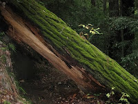
This park seems to be most popular with the locals, and few hikers venture away from the Fall Creek Trail. For most of the day, I saw and heard nothing more than splashing water, chirping birds, falling acorns, and my own footfalls as I trudged through the damp forest.

Don't get lost. Or hurt.