October 24, 2009

Relentless

When you reach the private gate marking the end of Soda Springs Road, you can only imagine the views hidden behind the trees at this altitude of some 3,010 feet. Lower on the mountain, you can catch the occasional sweeping vista that extends to the hills beyond San Francisco Bay.

Before you have traveled the first tenth of a mile along Soda Springs, gaze down at Alma Bridge Road more than 30 feet below. How is it possible that you have already risen so high? Prepare to suffer for the next 5.2 miles, as the gradient is remarkably steady (averaging 8.4%). To reach the top, you will ascend more than 2,300 feet.

Given that I climbed Old La Honda at the rate of 2,426 feet per hour, you can see what was in store for me on today's Low-Key Hillclimb. Soda Springs is longer and steeper - steep enough to tax my legs in addition to my cardiovascular system.

How did I do, mile by mile?
  1. 10:00 minutes, swept up in the excitement of chasing the pack.
  2. 11:20. The rider ahead of me has passed out of view.
  3. 12:25. So much for that early 10-minute pace.
  4. 12:45. Holding my own, more or less.
  5. 11:40. With descending riders cheering me on, I pick up the pace.
Sixty-two minutes and 42 seconds to cross the line. This is the price of laziness. For the past month, I have only gotten on the bike once a week. Not to discount last Sunday's cross-training expedition through the forest, I must get more exercise. The days are short, but I know how to set up the lights on my commuter bike. The mornings are cool, but I know how to dress for success. Next Saturday's climb is steeper.

October 18, 2009

Don't Fall in the Creek

Do you suppose they call it Fall Creek for the trees that fall into the creek?

Or is it named for the trees that fall across the trails?

Maybe the name celebrates the small falls cascading over rocks and logs.

It might be that Fall is the most colorful season to visit.

I cannot remember when I last ventured out on a proper hike, which means that too much time has passed. Or that I am getting forgetful. Too much time, that must be it.

Today I set out to enjoy my favorite hike in the Bay Area, a loop through the Fall Creek area of Henry Cowell Redwoods State Park. Normally, I would not hike alone, but I have gone too long without a hike to sit at home. I figured the two cardinal rules of hiking alone must be:
  1. Don't get lost.
  2. Don't get hurt.
As you have surmised by now, I made it safely home.

What's this, a day outdoors with no biking involved? True enough. But there were steep hills to climb.

There are no facilities in this part of the park; no trail map brochures, either. Fortunately, the map and description in my guidebook offered more detail than the park's online map. Despite some less-than-useful trail markings, I completed an estimated 8.2-mile loop with minimal back-tracking. Without locking onto a GPS signal for the first hour and a half (or longer), I captured only a partial track of my route. The critical moment was deducing that what appeared to be a rain gully was, in fact, the Lost Empire trail that would lead me to the high point of the hike (literally and figuratively): the Big Ben tree, a virgin redwood.

In the aftermath of last week's storm, I did what the state budget currently does not: minor trail clean-up.

This park seems to be most popular with the locals, and few hikers venture away from the Fall Creek Trail. For most of the day, I saw and heard nothing more than splashing water, chirping birds, falling acorns, and my own footfalls as I trudged through the damp forest.

Don't get lost. Or hurt.

October 17, 2009

First Impressions

At the end of my first day of skiing, I wanted nothing more than to soak my cold, wet, tired, bruised, sore, unathletic, out-of-shape body in a hot tub for the next day ... or two. Reasoning that skiing was popular, I knew there must be something I was missing. I gave the sport a second chance, and learned how much fun it can be.

The first time I tried a Low-Key Hillclimb, I was concerned that the racing types would look at me with a mixture of disdain and pity. Nothing could be further from reality. All cyclists truly are welcome, supported with shouts of encouragement along the way and cheers at the finish.

In 2007, I rode six of the nine climbs and learned what it was like to push myself to the limit. Last year, I approached each climb with a mixture of excitement and dread. I wanted to ride, but now I fully understood what it felt like to perform at the edge. Each Saturday morning was a struggle . . . why subject myself to an hour or more of lung-searing, leg-burning agony? Each week I won [or lost, depending on one's perspective] that battle; I rode five of the eight climbs.

The gracious folks at Potrero Nuevo Farm welcomed us to assemble at the Bike Hut this morning. The Bike Hut is a local treasure that Bay Area cyclists hope to enjoy for many rides to come. Hospitality, with a sense of humor.

I was not sure how long it would take me to reach the top this morning, but I figured it would be well over an hour. Today presented the longest climb of the series so far (7.6 miles), and I doubted that I could average any speed close to 7.6 mph going uphill.

Once the back of the pack sorted itself out, I found myself in an uncommon position: bracketed by two other riders. The distance between us was somewhat elastic, but our pace was pretty constant. Until, as in the immortal words of the legendary Phil Liggett, the elastic snapped. The guy ahead of me ran out of steam. It was one of those rare moments for me, as I passed him, to experience the sensation of being in a race (as opposed to a solo time trial). The guy behind would sometimes draw near, but I held him off. The only cyclists who passed me then were the mighty specimens with chiseled calves, including one guy on a shiny Cervélo who admired my Death Ride jersey.

From Tunitas Creek, we turned onto Star Hill to head for the rudest part of the climb, the aptly named Swett. I carried what speed I could into the turn and gave it my all. (I highly recommend this approach to avoid stalling out and toppling over.) Some say that the gradient is 19%. You can see the top of this segment from the bottom without having to tilt your head back too far, but with all the debris from last week's storm you had little choice other than to follow one of the two car tire tracks straight up.

If you had suggested that I would reach a top speed of 22.1 mph from a standing start, while heading up Tunitas Creek Road, I would have called you crazy. If you had suggested that I would find a place to shift into my largest gear while climbing Tunitas Creek Road, I would have given you a hearty laugh. Yet, today I did both of those things, averaging almost 7.5 mph to arrive at Skyline in 61:04.

This year, excitement has vanquished the dread. Each Saturday morning, I am eager for the challenge. I will never be fast, but I am having a blast.

October 15, 2009

On Thin Ice

I have pedaled more than 3,500 miles by bicycle this year. Recently, a stunned coworker said "I haven't driven that many miles."

My recreational rides may not be thoroughly green, as they often entail driving myself and my bicycle to some starting location, but a rough tally of my bicycle commutes surprised me: more than 1,200 miles so far in 2009.

I rarely drive to the office. When first presented with the option of taking a shuttle to work, I was unsure. Conform to a regular, rigid schedule? Not one of my strengths ... until I experienced how stress-free a rush hour commute is when you leave the driving to someone else. Not to mention the joy of a fast trip in the carpool lane, and fewer dollars converted to carbon monoxide in the process.

When it is not feasible to bike, I take advantage of the shuttle. The benefits of not driving are so substantial that I learned to schedule around this. Without a little forethought, it is easy to "need" your car every day.

I confess that I am not a purist; without apology, I indulge in some decidedly un-green activities. We all do. But whatever your feelings on the topic of climate change, it can't hurt to reduce your impact on the planet.

Blog Action Day 2009

October 10, 2009

Without Mercy

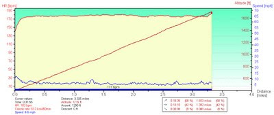
This graph expresses the highlight of my Low-Key day, setting a personal record on our renowned local benchmark climb, Old La Honda Road. My official time was 31:54.

The diagonal line represents the climb, with a gradient averaging 7.3%. The grade looks constant, but note the bumpy line at the bottom of the graph. That line represents my speed; for the most part, if my speed goes up, the slope has gotten flatter.

Finally, there is the relatively steady horizontal line at the top. That would be my heart rate, which climbed above 170 beats per minute after the first 35 seconds and averaged 177 for the duration of this exercise.

Like most Bay Area cyclists, I know this climb well. I know that I am stronger than the last time I charged up this hill. I knew that the rush of competition would make me go faster. I believed I could push myself very hard and make it to the top without fading. No mercy, today. I would glance at my heart rate monitor from time to time: 177, 180 beats per minute. Was my pace slowing? No. Well, no reason to back off, then.

When I reached the edge of the rough pavement near the top of the climb, I knew the end was near. I glanced down at my time ... I was close to finishing under 32 minutes! I accelerated ... I could hear the finish line ... the mailboxes were in sight. I crossed the line with six seconds to spare. Now you understand that final upward blip in speed (and heart rate) at the end of the graph.

Today I shaved two minutes, eleven seconds from my previous best time, and it was worth every heartbeat. All 5,646 of them (give or take).

October 3, 2009

Why I Climb

My top five reasons for bicycling up hills:
  1. The descent.
  2. The view.
  3. Chocolate.
  4. Fitness.
  5. The pain subsides at the top.
Today was the opening of the Low-Key Hillclimb season, which means that Reason #5 was necessarily promoted to Reason #1.

There is really nothing like charging up a hill in a pack of fast cyclists to test one's limits on a bicycle. Last year, many of us were caught in the rain; this year, the weather was sunny and cool. Last year, I was hurting and miserable; this year, well, I was just hurting.

I love the spirit of Low-Key: friendly, fun, full of good humor and encouragement. We are all out there mixing it up together: commuters, recreational riders, and racers from the local clubs. Road bikes, mountain bikes, an electrified recumbent, and a fixie (whose rider leaves most of us in the dust). Men and women of all ages. It's an open field.

When my Five-Pass Finisher jersey arrived yesterday, I took it as a sign. There could be no more fitting debut than this. I wore it with pride, and set a new personal best time on Montebello: 54:43, almost one minute faster than my best time in 2007, and at a lower average heart rate (173 vs. 177 bpm). Could I have pushed harder today? No, I am pretty confident that I gave it what I had.

I wasn't the last cyclist up the hill. Not ready to retire, just yet.

September 26, 2009

Who Knows?

My bike computer records the temperature, but since the sun is beating down on it, the readings are higher than the actual air temperature. I generally ignore anything other than the minimum temperature. Today's minimum was 70 degrees F, with a maximum of 114 degrees F; the average temperature was 100 degrees F. Who cares about the air temperature? The bike computer was baking in the direct sun, and so was I.

The last time I visited Paicines, I was helping with the Low-Key Mega Monster Enduro. It was so cold that my fingers were numb until well past sunrise. One thing I do know: the next time I climb Quien Sabe Road, the season will be winter (or maybe, early spring).

When I decided to do this ride earlier in the week, I said I would only do Quien Sabe if the weather was not blazingly hot. After refilling my water bottles at the Paicines General Store, I decided I would tackle the climb anyway. Yes, it was already hot, but I felt pretty good. I knew it was a long climb, and I had studied the terrain map. I had not studied the satellite view.

Quien Sabe Road is what one would call "an exposed climb." What does that mean? Great views, precious little shade. Another clue: to reach Quien Sabe, you pass through the town of Tres Pinos. I took my cues from the locals (cattle), and sought respite beneath any tree that cast an accessible shadow. There were, oh, at least a dozen patches of shade over the principal five and a half miles of the climb.

A first for me: I ran out of water. Around mile 45, I dropped to two mouthfuls at each mile mark. I knew I wasn't in trouble, but I knew I would run dry before I finished the ride. Shortly after mile 50, I passed a school. Must ... find ... drinking ... fountain. Sure enough, it was near the playground, and nicely shaded behind a building. About one liter and twenty minutes later, I comfortably finished the last two miles of the ride.

Conveniently, we had started our loop near a Foster's Freeze. Prescription: reduce core body temperature. One vanilla cone dipped in chocolate, taken by mouth.

Another milestone: Climbing 3,235 feet over 52 miles on today's route puts me at a new all-time high for a single year: 3,520 miles and 201,315 feet of uphill. The year isn't over yet ...