November 14, 2015

Picture Perfect Pacific Coast

Apart from an evening reception at the Monterey Bay Aquarium, I didn't have a plan. I didn't really need one.

I found a place to park and started walking northwest along the coastal trail.

Waves break offshore, rocky tide pools still as glass, Pacific Grove, California
An approaching winter storm, promising rain tomorrow, churned up some big waves.

Sky turns pink as dusk approaches along the rocky coast, Pacific Grove, California
Estimating how long it would take to walk back to the Aquarium, I kept an eye on the time.

But then I kept walking, reaching Point Pinos at sunset.

Sun dipping below the horizon at Point Pinos, Pacific Grove, California
At a brisk pace under the darkening sky, I made it to the Aquarium just as the doors were opening.

Moon jellies, Monterey Bay Aquarium, Monterey, California
The best plan can be no plan at all.

October 11, 2015

South County Cookin'

Fall days are often among the hottest in the Bay Area—like today, when local thermometers were approaching the 90F degree mark. Not an ideal day to spend the afternoon baking in the rural southern reaches of Santa Clara County.

Aermotor along Day Road, Gilroy, California
But there we were, making the rounds on our club's annual progressive dinner ride—a roving pot-luck feast. The challenge, I've learned, is not to over-eat.

After dropping off our contributions, three of us headed for the first stop: appetizers. I'm not sure why my couscous salad ended up there. Fresh veggies, asparagus wrapped in puff pastry, mini tacos, and a tasty garlic/shrimp dip.

Did I mention that bit about not over-eating? [Why yes, I think I did.]

Second stop: salads. Pasta salad, broccoli salad, kale salad, fresh strawberries. Healthy, healthy, healthy. [Okay, not the pasta; but we do need some carbs, we're exercising.]

Third stop: main course. Ham, turkey, macaroni and cheese, green beans, corn. Small portions; just a taste, really. [I was ready for my nap, here. My fellow cyclists were caffeine-loading, but I'm not a soda fan, diet or otherwise.]

Final stop: dessert. Here's where things fell apart. In past years, we could count on a veritable smorgasbord of luscious treats. This year, the organizers discouraged us from bringing desserts. For more than 30 people, there were only four desserts. No tangy lemon bars. No chewy brownies. No decadent chocolate mousse cake. The fruit salad had been set out with the appetizers.

Riders to the rescue! Pies were procured—berry, pecan, and more. [Whew. Close call.]

A flat 30 miles, with a mere 500 feet of climbing. Not a calorie-neutral day, but that's not the point ... is it?

October 4, 2015

Sunday Spin

Horse and young billygoat, Shannon Road, Los Gatos, California
Not every ride has to be epic. There is a certain charm to a short local ride ... a charm that includes sleeping in and biking to the start in mere minutes.

Whenever I toss out an invitation, I wonder if anyone will show up. Sunday morning, short ride, competing with other choices. Maybe two or three people will join me. If not, I'll just ride alone.

Eleven?! Eleven people turned up, sharing a similar frame of mind: Sleep in, do a quick local ride, spend the rest of the day in other ways.

A fine group on a fine morning, happily chatting away, looking out for one another, content to wait for the last rider every time we regrouped. At the top of the first hill we were entertained by a horse and a billygoat. Apparently not intimidated by the horse looming over him, the goat bounded over to check us out only after a commanding neigh.

On our way to the second hill, I heard that a rider had flatted. She was capable, and assisted by two other riders, but I circled back so she knew that we were aware. They caught up to us just as we were about to head for our third, and final, climb.

The end of the pavement on Reynolds was our turn-around point. It's a somewhat tricky descent, with sharp turns and enough grade to pick up more speed than you need. Near the bottom of the hill, approaching the final bend, a set of curving skid marks terminated ominously at a patch of melted pavement.

The group splintered after Reynolds; some to add another climb, others to head directly home. Three were game to visit the farmers' market with me. We took a back route through town on a tip that the high school's marching band might be practicing, but we were out of luck.

Not too late for a treat, though. For me, a crêpe slathered with Nutella, filled with fresh strawberries, and dusted lightly with powdered sugar. [Mmm.] A fair trade for the morning's effort, climbing 1,880 feet over 19 miles.

September 30, 2015

Search Party

Green geocache container nestled in the fronds of a palm tree.
To celebrate a recent successful product launch, our organization rewarded the team with a little getaway.

Engineers love to play, so this would not be simply a party. There would be a “team-building exercise,” which we regarded with skepticism and some wariness.

It turned out to be a fun (and tiring!) afternoon, geocaching. Anticipating the usual “count off by ones” method of separating people from their buddies, I managed to land on a team with a co-worker who has some geocaching experience.

Nonetheless, it was surprisingly challenging. Each team needed to stick together, and they warned us that no team would be able to visit all the caches in the allotted time. Yes, we were working against the clock, in two one-hour sessions. “Now I know how to take all the fun out of geocaching,” my co-worker remarked as we huffed up steep trails and made sure to return to the check-in point on time.

There were a few organizational twists [team-building, remember?]. Teams needed to report their discoveries back to “headquarters” (as it were), and all teams needed to rendezvous at a central point on schedule. Those who were tardy paid a hefty penalty, losing half their points. By checking in with headquarters, we were also trying to ensure that every cache was found by a pre-ordained minimum number of teams.

Despite having the advantage of an experienced geo-cacher, we didn't do all that well. There was a premium for being the first to find any given cache, which we never managed to do. And the caches with the highest points value tended to be time-consuming: complete an additional activity after finding the cache, or solve a puzzle to discover the coordinates of the second part of the cache.

We got sweaty. We got sore. I think we managed to avoid contact with poison oak as we traipsed through thickets and looked for shortcuts.

When asked to share strategies that worked for us, I offered “Be opportunistic!” The organizer gave me a sly look. “Cheat, you mean?” Not exactly ... but with so many teams unleashed simultaneously, it would have been impossible not to notice the discovery of a nearby cache. Coopetition?

In the end, I scored a winner's ticket for a massage when another co-worker had no interest in using it. Go, team!

Sunset in shades of yellow, orange, pink, and purple, Santa Cruz, California

September 26, 2015

Three Threes

It seemed easy enough: three hillclimbs, all rated level three (least hilly, in our club's vernacular).

Dry hills with tall flowering stalks in the foreground, San Juan Grade, San Juan Bautista, California
By the time we were done, I had no motivation to follow some of our riders on a little side trip—no, not even for the view.

Yet, the climb to reach the entrance road for Royal Oaks Park was so undaunting that I was convinced (convinced!) that we must climb it from the other side, which is so much steeper, when we visit this park for lunch on the Strawberry Fields rides. [Bzzzt! Wrong!]

I was intrigued by today's route because it included a new, unfamiliar hill to climb. The name “Crazy Horse Canyon” was tantalizing. The reality, well ... was not.

I paused at the intersection after enjoying a smooth descent down the back side of San Juan Grade (the front side of which is more rut than road). I watched truck after huge truck turn onto Crazy Horse as I waited for the rest of the group to catch up. There are entrance (and exit) ramps where the road meets Highway 101, and therein lies the problem.

Thirty-one miles with some 2,320 feet of climbing. It wasn't the horses who were crazy, it was the cyclists.

September 19, 2015

Highs and Lows

High point along Loma Prieta Way, Los Gatos, California
With another wave of heat forecast to smother the Bay Area, a shorter (and shady) route was in order. After a refreshing climb through the redwoods, we headed up Mt. Bache for a view from the ridge below Loma Prieta. On the plus side, with no fog in sight we had a clear view of Monterey Bay. On the minus side, even though we tackled the climb early, we were baking. It seemed much harder than it should have been, but then some of the ever-so-patient riders in our group consoled me with reports that the grade hits 11%-13%.

Ghoul with glowing red eyes, holding a sign "I (heart) Meat Bonanza, Summit Store," Los Gatos, California
It's a bit early in the season for the ghouls to be out, but we did find a couple of meat-loving fiends at the Summit Store. Having survived the brutal climb along the ridge, we had no fear of looking these devils in the eye. We snacked and hydrated and clustered beneath the patio umbrellas before torturing ourselves with the next climb.

The group began to splinter, with some riders tackling more hills (extra credit), and some ending the day a bit earlier. Most of us coasted down to Los Gatos Creek at Wrights Station, just so we could climb back up. [Really, cyclists are a bit daft.] There was little water trickling beneath the bridge, but we were grateful for the towering redwoods. The cool shade was so tempting ... why am I not stretched out with a good book in one of these groves?

Aldercroft Heights Road passes through the redwood forest, Los Gatos, California
I continued with my original plan, following Los Gatos Creek from the other side, through Aldercroft Heights back upstream (and, of course, uphill). Oh, wouldn't it be swell if we could have simply biked back along the creek from Wrights Station? Just look at the map. But alas, it's private property, festooned with razor wire.

The ride was a couple of miles shorter than I had estimated, and [ahem] a bit hillier: 33 miles, with a stout 4,100 feet of climbing. I so wanted to spend the rest of the afternoon napping in the forest, but ... home I went.

September 12, 2015

Coastal Caravan

Misty coastline near Big Sur, California
The first couple of times I did this ride, the Best Buddies Hearst Castle Challenge, I was itching for a faster start. We were paced out at a leisurely 12 mph or so over the initial 10 miles, which was a penalty for me because that was terrain I could cover at a faster speed.

Oh, how times have changed. With former Olympians and pro riders at the front, including Christian Vande Velde and George Hincapie, this year I lost the wheels of the front of the pack before our u-turn at Robinson Canyon. I rode my heart out, averaging 18 mph for the first 30 minutes, but resigned myself to surrender. A local woman would cross the line first today, champion rider Christine Thorburn, in 4 hours, 46 minutes, 13 seconds—besting Christian and George by 3 seconds. [Well done, Christine!]

Kelp and turquoise water along the California coast, south of Big Sur
I, on the other hand, availed myself of rest stops along the way and stopped to snap the occasional photo. It wasn't a picture-perfect sort of day; it was warm, but there were only brief glimpses of blue skies to the east. The sun peeked out for all of about five minutes.

One factor that slowed me down this year was the traffic. More traffic than I've ever experienced on this ride. Along one stretch, I passed the same vehicles multiple times. Not only did I lose precious momentum on a key downhill, I had to pick my way gingerly alongside SUVs and motorhomes crawling up the hill. In one case, a few of us threaded our way through stopped traffic to the left of a Cruise America RV that left no room to ease past on the right.

Teal water in a cove along the California coast, south of Big Sur
It was quiet along the open road. The air was still; no tailwind for the final miles, but no headwind either. Between the layers of low clouds, the sky had a pinkish hue above the horizon. Pelicans, silhouetted against the gloom, glided past at eye level—some heading north, some south. I spied a juvenile snake in my path with little time to react; I think I managed not to clip it.

A volunteer at a rest stop looked out at the Pacific and asked me what was on the other side. I smiled. “Well, it's the open ocean, it's a long way to the other side.” Then I asked where she was from. “San José,” she replied. [Sigh.]

Even though I was slower this year, I found myself passing people. Quite a few people. I played leap frog with a couple of riders for much of the day, but dropped them for good as we headed toward the final pair of climbs. I didn't mind those so much this year; and as in prior years, I passed riders who were walking (or, sitting) on the penultimate climb. Over the years, some riders would sign up to ride the century, confident that they could rely on a SAG vehicle to carry them over these hills. The organizers had been especially complicit over the past two years, providing a full-on truck to carry bikes and vans to ferry people.

Not so, this year. I watched a guy try to flag down a regular SAG van as it rolled past, but it was full. He would have to wait a bit longer.

Victorious pep after riding 100 miles, at the finish line, San Simeon, California
Cresting that second summit means one thing: It's time to hammer on to the finish line. Even without a tailwind, I was gratified to pick off many riders along the way. I'd see one ahead, in the distance, and think it wouldn't be possible; but time and again, I'd reel them in. They were too spent to give chase.

Throughout the day, I reflected on how much each mile was worth in terms of the money I'd raised for Best Buddies, and I'd pedal strong and proud. I was determined to keep enough people behind me to stay clear of the well-meaning course marshals who sweep the route. Coming down off the final climb, I estimated that my on-bike time would be 7 hours, 40 minutes. I was thrilled to be wrong, crossing the line in 7 hours, 30 minutes. I wasn't last. I wasn't even the last woman. For the day, 100 miles with some 6,280 feet of climbing; average speed, 13.2 mph.

The Pointer Sisters entertained the crowd at the post-ride barbecue, which puzzled me because ... I went to a Pointer Sisters concert when I was a teenager. [That was some time ago.] Our generous host, Steve Hearst, shared the genesis of this event. Anthony Shriver had called him with a proposal for a ride that would start in Santa Barbara and end at Hearst Castle. “People will die,” Steve replied. “You need to start in Carmel.” And here we are again, 12 years later.

I was excited to have a chance to chat with Christian Vande Velde, who was a genuinely nice guy. I was looking for my buddy Cameron, to thank him for his help last fall. They'd announced his name at the start, but Christian explained that he was out with a broken foot (and, training for Kona).

Neptune Pool at Hearst Castle, still drought-dry, San Simeon, California
The post-party party up on the Enchanted Hill seemed smaller than usual. Being an early bird for a guided tour, I was treated to a one-on-one (!) visit to two of the cottages.


The famous pool is still drought-dry. Maybe, next year?

September 5, 2015

Top It Off

I haven't pedaled to the summit of Mt. Diablo in a while. It's a tall ask, that last 235 meters. Over about 0.15 of a mile, the road rises 105 feet.

Could I do it? I've done it before. But the last few times, anxious about having a car behind me, I've abandoned and walked.

Today seemed like an ideal day for an assault: Day one of a three-day weekend. With the crowds headed to the beach for summer's last hurrah, I expected few to choose a drive to the top of the mountain.

I was right.

With my heart rate more or less in check, I looked up at that final ramp and continued without a rest. It didn't look as steep as I remembered, but I knew it would hurt. A family hiking down encouraged me. “Good job!” they called out—even the kids.

My heart rate climbed by twos and threes, sampled every five seconds, topping out at 181 bpm for half a minute. Two and a half minutes of suffering, that's all it took. [That's plenty.] Average heart rate: 176 bpm.

A few years ago I had a cardiac stress test, running on a treadmill. They stopped the test at 173 bpm, which they considered 104% of my maximal heart rate. [Pffft.]

It was surprisingly windy, and the wind was surprisingly chilly. I watched other cyclists donning layers for the descent. Ah, well, the faster I go down, the less time spent feeling cold. We watched smoke rising from a fire to the west and fretted about the wind factor. It was a 10-acre grass fire in Sunnyvale, which they fought rapidly to contain. [Whew.] The mountain is recovering remarkably well from the fire that scorched it two years ago. Some evidence remains, like the blackened dead tree that virtually brushes up against the historic stone building at the top. That was a close call, up there.

I was most of the way down when a line of three cars came into view. A minivan, a pickup truck, and a mini-Cooper. Guess which one was in the “lead” (and I use that term loosely). I kept my distance, but I really don't like having to brake behind cars. I'm sympathetic; I'm sure the minivan doesn't handle particularly well, and maybe the driver doesn't enjoy the challenge. But, sheesh .... pull over and let the traffic pass. [Eventually, she did.]

There's a bit of an uphill near the bottom, and I could hear the minivan catching up to me. I was about to crest the hill; I took the lane, hoping to keep her behind me. Reassuring me of her poor judgment, she passed me nonetheless. And immediately slowed as she started going downhill. Slow enough that, when the opposite lane was clear, I pulled around and passed her. Unlike the (large) guy who coasted (!) past me on the way to the top, with his battery-powered electric bicycle, I don't have a motor. The minivan does.

A fine workout on a fine day: 31 miles with some 3,840 feet of climbing.

August 22, 2015

Wildlife

Paraglider near Sandy Wool Lake, Ed Levin County Park, Santa Clara County, California
The first wildlife sighting was the guy sitting in his car, windows down, at the summit of Old Calaveras Road. Smoking pot. I guess he thought he was in the middle of nowhere. But at 9:15 a.m., really? I was glad he was pointed downhill, as I hoped we would not cross paths with him later.

The paragliders and hang gliders were setting up on the hillside above Sandy Wool lake, as usual; some were already in flight.

Heading up Calaveras toward Felter, a couple of turkeys made an appearance. I've seen them here, before.

The usual turkey vultures, and a hawk, soared overhead on Felter.

California Red-Sided Gartersnake on the double yellow line, Felter Road, Santa Clara County, CaliforniaThen there was this snake hanging out in the middle of the road (California Red-Sided Gartersnake, Thamnophis sirtalis infernalis). There's not much traffic on this road, but after I was passed later by a huge flatbed truck hauling fancy barbecues, I'm not convinced the snake's day ended well. Even if it stayed right there on the center line.

I caught a glimpse of a Western bluebird as it darted above the road.

The biggest moment of uncertainty was yet to come. Sierra Road is steep, which makes for a fast descent. A coyote popped off the hillside and started running along the road in front of me. (Yikes.) Did it see me? If I pass it, will it give chase? Can I pass it safely, at all?

I pressed the brakes, hoping the right choice would become more clear. Lucky for me, the coyote decided to turn right up the hillside before I got too close. (Whew.) They normally don't attack people, and this one looked adequately fed, but ... who knows?

I had wanted to climb a third hill today, but my legs just weren't up for it. Felter seemed longer and harder than I remembered; the third hill seemed like a bad idea. Each time the road would descend a bit, giving me a break, I'd think “That third hill is only 1.3 miles, how bad can that be?” Then the road would climb a bit and my legs answered No!

I kept it short, 19 miles with 2,500 feet of climbing. With 100 miles of commuting in my legs this week, that was enough.

August 17, 2015

Happy Trails to You

Farewell to cyclists passing me on blind curves.

Goodbye to the graffiti tags and homeless encampment.

Arrivederci to groups who block the entire trail, walking three abreast.

Toodle-oo to the joggers who abruptly stop, mid-trail, and flip a u-turn with no regard for people behind them.

Adiós to the iDiots, white wires dangling from their ears, oblivious to the world around them.

Auf wiedersehen to cyclists turning onto the trail without a glance for oncoming traffic.

To the dog-walkers with their leashes strung across the trail ... bye-bye.

Three cyclists and a pedestrian at the south end of the bridge over Evelyn, Central, and the railroad tracks, Mountain View, California

When the Stevens Creek Trail was extended across a freeway a few years ago, taking it seemed like a game changer. More than four car-free miles without stoplights!

Armchair cyclists, fearful of sharing the road with cars and trucks, long for trails like this to ride. If only ... if only there were trails connecting home to office, they just might make the trip by bike instead of car—they're sure of it.

Whenever I would tell a non-cyclist that the trail was the most treacherous part of my commute, they stared at me in disbelief.

I've had more close calls on the trail than on the street. Generally, motorists are predictable and follow the rules of the road. Trails, on the other hand, are a free-for-all.

Recently the city announced some changes for the Stevens Creek Trail. A speed limit of 15 mph (which, actually, was already the case). Electric bicycles and skateboards would now be permitted.

Just what we need. Commuters on heavy motorized bikes who know nothing about cycling etiquette. Skateboarders who fly down any incline they can find, over and over again.

The speed-limit announcement implied there would be enforcement. An electronic sign, registering and recording speeds, appeared along the trail for a week or so.

Surely that wouldn't affect me? On the heavy hybrid I use for commuting, cyclists are constantly zipping past me. And I'm a courteous trail user, slowing as I approach others, ringing my bell. People wave, and smile, and thank me.

Then I looked at the data. [Uh oh.]

I'd been routinely cruising along the straights at 16-17 mph. If the trail is clear, I'm much faster coming down the bridges. The last thing I want is a slower commute. [Or a citation.]

I shuttled to work this morning, but biked home in the evening. It's been a few years since I adapted my route to take full advantage of the trail, but I can do well without most of it. In the morning, I can bypass it entirely. In the evening, the trail is the safest way to cross the freeway, expressway, and railroad tracks. Then, exit, stage right.

To my surprise, my old route was actually faster—despite getting caught by two red lights. Without having to slow down to pass every meandering body on the multi-use trail, I was able to sustain a more constant speed.

Sayonara, Stevens Creek Trail.

August 8, 2015

All Quiet on the Mountain

More than halfway through the year, and I hadn't climbed Mt. Hamilton ... unthinkable. Today was the day to fix that.

Three deer running in a field at Joseph Grant Ranch County Park, San Jose, California
The temperature was perfect, and for some reason there was little traffic; motorcycles, mostly.

Layer of gray smoke hangs over the valley, view from summit of Mt. Hamilton, San Jose, California
Along with little traffic, there was little breeze and little view. There is likely a relationship among those three elements. The sky was layered with smoke from distant wildfires.

I paused to watch some deer munching on the still-green leaves of a large branch that had snapped off an oak tree. Flora and fauna, stressed by the drought.

Three deer dining on oak leaves alongside Mt. Hamilton Road, San Jose, California
There were, of course, other cyclists. I chatted with a couple of first timers, and passed an over-dressed guy who was struggling. He hadn't gotten much farther when I passed him again on the way down, despite the additional time I'd taken for lunch at the top.

I'd heard they'd done some work on the upper section of the road; notably, they re-graded a gnarly switchback near the top, making the steep inside curve more gentle. On one trip up the mountain, I had witnessed a motorcyclist stall and tip over on that curve. With its wheels uphill and weighty body downhill, he needed help to stand the bike back up.

I was surprised (and mystified) to see Cipollini's name freshly stenciled on the road in multiple spots, as he retired some time ago. And he's not exactly local.

For the day, the usual 39 miles and 4,860 feet of climbing. My favorite.

August 3, 2015

Lake Shasta Caverns

We're heading back to the Bay Area today, but that doesn't mean we can't find some more fun.

View of Lake Shasta from the hillside above, near entrance to Lake Shasta Caverns, California
My ride buddy had done her research and found an attraction that wouldn't have been on my radar screen: Lake Shasta Caverns. It's even a National Natural Landmark, like Burney Falls (which we visited last year) and Mt. Shasta itself.

Our timing couldn't have been better. We arrived early, but missed the first tour of the day (a busload of tourists). For our small group, it felt like a private tour.

Catamaran waiting to ferry us across Lake Shasta to the caverns, California
We hiked down to the water's edge to catch a boat across Lake Shasta, which is fed in part by a river we visited two days ago. With the drought, the water level is down by some 150 feet. Over such a huge surface area, that's a lot of missing water.

On the other side, a small bus carried us up to the door where we would enter the cavern. Our guide filled us in on some history and interesting facts along the way. She claimed that poison oak will mimic the plants around it, which is something I'd not heard before (and, have not been able to substantiate). She also told us about treating the rash with Manzanita, which has indeed been recommended elsewhere. My strategy is to avoid the devilish vines in the first place, but I'm filing that remedy away in the “good-to-know” category.

California Sister butterfly near Lake Shasta Caverns, Lake Shasta, California
Along the way, a friendly California Sister (Adelpha californica) posed nicely on the fence rail.

I haven't visited many caves; my family just wasn't into that. The caverns were unexpectedly fascinating, with a great variety of formations—not just the stalactites and stalagmites you'd expect. Flowstone, for example. The floor could be pretty slippery; there were handrails, but shoes with stickier soles would have been better than my hiking boots.

Stalactites, Lake Shasta Caverns, Lake Shasta, California
Most of the formations are “alive” (still growing). Our guide's flashlight illuminated the difference. Only the living formations had a translucent glow. We were cautioned not to touch, as the oils from our hands disrupt the chemistry and “kill” future growth. One room was an exception to this rule, including a formation that invited us to crawl inside.

pep inside a formation in the Lake Shasta Caverns, Lake Shasta, California
A natural entrance to the cave was high above us in the last “room,” which was enormous. Bats swooped overhead as we stood there, admiring the spectacle.

I'm a curious sort of person, but I have to admit that, had I stumbled across the entrance to these caverns I would not have ventured inside. Especially with the primitive tools and lighting available in 1878. Thank you, Mr. Richardson.

August 2, 2015

A Social Century

The Mount Shasta Summit Century is the reason my biking buddy and I drove up to Siskiyou County. “Summit” is a bit of a misnomer; the ride ends, along with the paved road, at an altitude of 7,780 feet. There's quite a bit of mountain above that point, as the peak tops out at 14,179 feet.

The ride is put on by the local chamber of commerce, so we were surprised to see no hint of the event as we walked around town. No flyers. No posters. No signs. When we hiked at Castle Lake, we saw a notice that the parking lot would be closed on Sunday [rest stop], so we felt reassured that they hadn't called it off and forgotten to let us know.

We had registered for the full century, but as we did last year with the Fall River Century, we concocted our own route. We're the Goldilocks of cycling: 100 miles with 10,500 feet of climbing is too big, and 59 miles with 4,000 feet of climbing is too small. And of course we wanted to bike up Mt. Shasta. Shorten a loop here, skip a climb there, and go up the mountain. Just right.

Imagine our surprise when the first cyclists we met en route were a couple from our own bike club, on their tandem.

This event was the most social century of any bike event I've ridden. Normally, the hard core cyclists zip past without a word, intent on making good time. Not today. I had so many nice conversations with cyclists who slowed to chat. I called out to a couple of guys wearing a jersey from my home state—that's something I've never seen before, as it's hardly a nexus of cycling. One lives in California now, and his brother flew out to do this ride and spend a couple of weeks touring the Pacific Northwest.

There were also more women riding than I have ever seen at a cycling event (with the exception, of course, of the Cinderella). And they, too, were friendly. I was wearing a jersey from one of our club events, and some women admired it as they passed. One recognized the club and raised a fist in triumph, shouting “Sierra to the Sea!” She'd had the chance to do that ride.

Another first was the woman riding up the first climb on a mountain bike ... with three sled-dogs-in-training yoked together.

Raindrops started falling just as we finished lunch. We kept going. Sprinkles are fine; a downpour and slick roads, not so much. When I'd heard a thunderclap on the morning climb, I wondered just how we would find shelter in a lightning storm (surrounded, as we were, by really tall trees). A cyclist who was cutting his ride short offered me his jacket, asking only that I return it later to his hotel. But it was a warm day, and here's the thing: Once you're wet, you're wet. The raindrops actually felt good.

Early on the slopes of Mt. Shasta, something caught my eye just off to the side of the road. How silly, I thought; why would someone put a statue of a deer out there in the forest? [Duh.] It was a live doe, standing so still and with a coat so perfect she didn't look real. She was watching me. “Hi there,” I said. “Be careful if you're going to cross the road.” As soon as I passed, that's exactly what she did. Luckily the woman driving an oncoming car saw her, and slowed.

I was a bit apprehensive whenever I passed someone walking along the road. What are they doing, basically in the middle of nowhere? Are they going to harass me? The guy in the green t-shirt, carrying a paper grocery bag, cheered me on. “Great job!” he called out. The scruffy mountain man, with his long hair and longer beard, greeted me with a friendly hello.

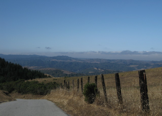
The climb itself, 15 miles at a gentle 5.6% grade, didn't even require my granny gear. Nonetheless, being unfamiliar, it seemed everlasting. “You did the Death Ride,” I reminded myself: twice the climbing. Keep turning the pedals. I noticed the thinner air around 7,000 feet. “You climbed above 10,000 feet last year,” I told myself. No excuses.

By the time I made it to the top, I was more than ready to be done. And looking forward to the descent, with its smooth pavement and wide sweeping turns. Three of us took off at the same time, and I was finding it a challenge to keep a respectable distance. When I reached a comfortable place to pass them, I did. Later, when they arrived at the finish, the woman saw me. “You're a great descender!” she said. Thanks, I smiled. “I followed her all the way down!” she announced.

Two fast guys had flown past me; I know better than to give chase. A woman passed me, too, and gained some distance but stayed within sight. I could play with that. Just by tweaking my aerodynamics, and with greater comfort in the curves, I started gaining on her. She was surprised when I passed her. “It's a great descent!” she shared, when she pulled even with me again.

For the day, 79 miles, 7480 feet of climbing. My legs hurt. Just right.

August 1, 2015

McCloud Falls

Mt. Shasta is a curious town. As we waited in line for a sandwich at the local natural foods market, it was hard to watch the inefficiencies behind the deli counter (and not intervene). I will say that the food was worth the wait.

There were lots of shops selling crystals. Our hiking buddies from Heart Lake had shared an amusing encounter: They had been in one of the shops when a guy wandered in, claimed he was the 16th incarnation of Buddha (or some such), and demanded a particular crystal of significance that was on display. Or else he would blow up the shop. [Which, of course, is just what Buddha would do.]

McCloud River, McCloud, California
Our afternoon plans included a much less strenuous hike than this morning's. We headed for McCloud Falls, which is really a series of three waterfalls along a stretch of the McCloud River.

I envied the families playing in the water, scrambling over the boulders and jumping off the rock walls. [Well, not so much the cliff jumpers. I'm too chicken for that.] It was refreshing to see so much unbridled splashing and sliding, with no signs or officials in uniforms shooing people away “for their own safety.” I wished I'd brought a bathing suit.

Swimmers at the Lower Falls of the McCloud River, McCloud, California
Here, it was a little less hot than on our earlier hike. The distance to the upper falls was not clear; we needed to return to town to pick up our registration packets for tomorrow's ride, so we kept walking with an eye on the clock.

Man jumping off cliff at Middle Falls of the McCloud River, McCloud, California
As we were climbing the uppermost segment, two young women came running down the rocky trail. And one tripped. My ride buddy, walking just ahead of me, caught her. Most importantly, in that brief-but-terrifying moment, both of them stayed upright and neither one tumbled over the cliff.

Upper Falls of the McCloud River, McCloud, California
We made our u-turn at the upper falls with ample time to hike back down. Then we spotted a crowd heading for the narrow trail. Wearing ... costumes? Colorful broad-brimmed hats, South American style. Did they step off a bus in the parking lot, above? It was as though someone had conjured a line of zombies, as they marched along with blank expressions. My ride buddy and I looked at each other. “Let's go!” And let's stay ahead of them.

And so we lived to tell the tale. 4.1 miles, round-trip, with much less climbing than our morning adventure.

Heart Lake

My ride buddy proposed that we head north for a cycling event near Mt. Shasta. We didn't get to see much of the mountain last year, after all. As we did then, we made the most of our short time in the area by adding a couple of hikes.

We planned to skip one of the climbs on tomorrow's route, the better to accommodate our pace. The question was, which one?

After poring over maps and hiking recommendations, we opted to skip climb number two (Castle Lake). Today we would hike there, instead.

Castle Lake, near Mt. Shasta, California
Rather than a trail, at times it felt more like we were hiking in the dry wash from the slopes above—loose rocks always underfoot. We started at Castle Lake, heading for Little Castle Lake, above. It was a steep climb, and the trail was essentially unmarked.

Hiker on rocky trail through a meadow, with Mt. Shasta in the distance, on the way to Heart Lake, Mt. Shasta, California
We found Little Castle Lake, but not a way to get close to the shore. I made three attempts, more or less bushwhacking my way along what appeared to be footpaths, but each fell short.

Little Castle Lake, near Mt. Shasta, California
We also wanted to find Heart Lake, but ... how? We hadn't noticed other trails branching off; had we missed a marker along the way? On our way down, a small path led to some large rocks. If only we had known that was also the way to Heart Lake ...

I scrambled up the rocky outcropping and was rewarded with a sweeping view of Castle Lake, with the top of Mt. Shasta floating above the layer of smoke from this year's distant wildfires.

Mt. Shasta rises above the smoke layer, near Mt. Shasta, California
As we hiked down the hill, a small group passed us, heading up. They were oddly dressed—in street clothes, some carrying babies. A woman in a casual white lacy dress; a guy in a dress shirt, vest, and pants; a woman in a long skirt. Ah, well, that's California for you. I've seen people climbing a trail up the slick, sandy rocks next to a waterfall in leather-soled shoes.

Of course, there were wildflowers along the way.

Swamp knotweed (Persicaria amphibia) near Castle Lake, Mt. Shasta, California
And with a little patience, I got a clean shot of a butterfly (Aphrodite frittillary?) that was flitting alongside the trail.

We made it all the way back to our starting point, still mystified about where we missed the turn to Heart Lake. Our timing was lucky: we got some tips and joined a friendly couple who were also trying to find the lake. Then we turned around and trudged back up the steep slope. [Oh no ... say it isn't so.]

Wedding on the shore of Heart Lake, Mt. Shasta, California
When we reached Heart Lake, well, there were the hikers in their fancy clothes—a wedding party. [Aha!] They knew how to find Heart Lake. We witnessed their vows from across the lake, with Mt. Shasta in the distance, and cheered.

Heart Lake with Mt. Shasta in the distance, near Mt. Shasta, California
My ride buddy had suggested that we tackle this hike in the morning, and she was oh-so-right. It was a hot day, and a hard 4.5-mile hike. Both times up the hill.

July 25, 2015

The Wild Wild West

The locals are so welcoming on Bay Area backroads.

As we turned west onto Bear Gulch Road, there was one to greet us. With his faded brown sedan parked next to the cluster of mailboxes, he shouted:
You're not going through to the coast!
“No,” I replied; “we turn around at the bottom and ride back up.” (The public road is a dead end, with a well-marked gate demarcating private property.)

He continued:
If I find you on my ranch I'll fill you full of buckshot!
So noted.

View of fog-shrouded Pacific Ocean from Bear Gulch West Road, near Woodside, California
Here in the 21st century, we have plenty of detailed maps to guide us. It would be stupid not to consult them. And it would be even more stupid to trespass on private property.

I can only imagine that, to this paunchy redneck with his stringy hair grazing his shoulders, that the stupidest idea of all would be that two women on bicycles would coast effortlessly to the bottom of a really steep hill just to make a u-turn and pedal back up.

Nah, we're really cattle rustlers in disguise.

I half expected him to drive back down the hill and park at the end of the road. I picture him sitting on an old lawn chair somewhere on his property, his shotgun across his knees, still waiting for us to arrive. Disappointing, on so many levels.

White road marker with a yellow top, Old La Honda, alt. 1634 ft, near Woodside, California
I hadn't climbed Old La Honda Road in awhile. I wasn't trying for a personal best, but I will say that it took less effort to pedal the new bike up the hill. Reaching the summit on this penultimate day of Le Tour de France, it was fitting to discover that someone has created a traditional French-style road marker and planted it there.

Snacking at the top of Kings Mountain before starting our descent, we overheard a conversation between some nearby cyclists and a very lost motorist. When they told him to head down Kings, my ride buddy and I looked at each other. Go, now, before we get stuck behind this guy who has never seen Kings Mountain before.

I'd forgotten how long that descent is. There was only open road ahead of me, as I took care not to let the fast bike accelerate to warp speed. An SUV appeared behind me; I had a clear advantage on the curves, and there were no straights long enough for him to pass me safely. He'd just have to wait. Besides, I was doing the speed limit (or better).

For the day, 3,440 feet of climbing over about 26 miles. And no buckshot.

July 24, 2015

Change Up

One morning this week, the same cyclist passed me three times.

Wait ... how can that be?

Looking west along the channel where Stevens Creek meets San Francisco Bay, Mountain View, California
Of the two of us, he was the stronger cyclist. But I was the cyclist following an optimized route. He never said a word, but he must have wondered what was going on. I chuckled to myself.

The downside of my optimized route is that it can get dull—same old, same old.

I became familiar with “the regulars:” people whose routines overlap with mine. In the morning, the woman walking a pair of pit bulls (who make me nervous). The guy with the rambunctious puppy. The small elderly guy with long sideburns and a mustache who stood near the center of a bridge looking at ... what? Not necessarily the trains.

Evenings are less routine, though I would often see an elderly woman in a saffron-colored sari and her husband, out for a stroll. A large woman in a wheelchair near a convalescent center, parked on the sidewalk, reading a book. Sometimes a colleague might come along and chat before dashing away.

I've been wondering whether I should change the route to ease the boredom. But every time I study the map, I stick with my route. It's pretty safe, and quiet, and direct. Now and then, something unexpected spices it up.

This week a friend got up early, rode to my house, then returned with me along my commute route—just for fun. Two weeks ago my older road bike made for a fast trip; the Bike Doctor would be on campus, and it needed a little TLC. [New brake cables, as it turned out. So that's why it wasn't stopping very well ...]

One evening I passed a helmet-less guy in a long-sleeved white jersey, stopping irregularly to pick up trash. This week, a guy wearing an orange safety vest, a human face mask strapped to the back of his helmet. A woman struggling with a jammed chain, hands covered in grease. [I stopped to help.]

Late afternoon took me to the central part of the campus for an unexpected meeting. I had biked to work specifically to avoid the traffic meltdown that ensues when there's a major event at the nearby concert venue, but now I would land in the thick of it. I really didn't want to be on the road until I was well clear of the concert traffic.

The map confirmed my hunch: I could roll straight onto a different creek trail, follow it east to pick up the Bay Trail, loop around and catch the trail I needed to head home.

Variety is the spice of life.