It started out like any other summer lunchtime. My colleagues had commandeered a nice set of tables in the shade.
I'm not really a tie-dye sort of person, but this week I thought I would try to drum up some action for the bi-monthly blood drive on campus. Each day I have sported a different Grateful Life Tour t-shirt—an annual gift from the Stanford Blood Center for mid-summer blood donors. Monday was blue, Tuesday green, today was orange.
Starlings know a good gig when they find one, and a bunch have taken up residence. A female hunting for some fallout caught my eye. A dried-out fragment of a redwood branch was stuck to her left foot, maybe tangled with some string. Her right foot was missing altogether. She hopped around awkwardly, and a few of us wished we could do something to free her left foot, but didn't think we could safely nab her.
The story gets better.
She hopped closer and closer to our table, and then we saw her eye on the prize: A praying mantis. Not just any praying mantis, but a white praying mantis. When she got close enough to peck at it, it reared up and spread its wings, Transformer-like. (Whoa.) The startled bird backed off. After nearly being crushed by an ill-placed footfall, the mantis headed for our table and perched on an engineer's jeans. We dispatched him to the grassy area, which encouraged the creature to move on. (Apparently they are white after they molt.)
It gets better still.
That's when a large bug buzzed my way: A HUGE green beetle, which seemed very interested in my bright orange shirt. I held still; it landed on my hand and proceeded to inspect my arm as it slowly crawled toward my elbow. It was a handsome creature, green with black legs. I'd say it was a June bug, but I don't think there are June bugs in California. [I believe it was a Figeater beetle.]
The story gets even better.
A couple of guys at the far end of the table were completely unnerved. They were ten feet away and ready to bolt. “I can't believe you're letting it walk on you!” It's not a stinging insect, it's not going to bite, I replied. “And most snakes aren't poisonous, either!” they exclaimed. The beetle lost interest in my arm and hovered near my shirt again. When it buzzed into my face, I swatted it away.
I was, after all, just trying to eat my lunch. Burger, not beetle.
August 6, 2014
August 2, 2014
Down There
With more warm weather in the forecast, I hatched a plan to seek more shady redwoods. Meeting some shady people is often part of that bargain.
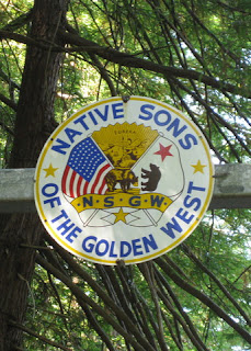 Climbing up Native Sons, a woman heading down in a large pickup stopped next to me. “Did you come from down there?” she asked. Which, on the face of it, is a patently stupid question. I gave her a friendly “yes” and continued on my way.
“Down there” is a gate at the end of the public road. The gate happened to be open today, but we respect private property. I should have replied “We came down from the top and made a u-turn at the gate,” which might have allayed her suspicion that we had somehow trespassed “down there” on our way to Skyline. Or maybe not, since none of us are Native Sons of the Golden West.
It is easy to forget that, to a hefty person driving a beefy pickup truck, it is inconceivable that anyone would deliberately ride a bicycle downhill on a dead-end road just to turn around and ride back up. Today we did that not once, but twice: first on Native Sons, then on Star Hill. Having first climbed Kings Mountain, we climbed some 3,500 feet on our little 25-mile excursion.
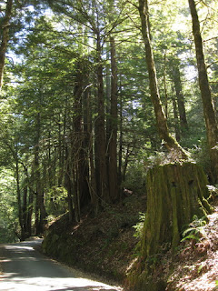 These narrow back roads might leave you wondering why they exist, until you pass the decaying stumps of huge redwoods. It is a good guess that these were once logging roads; most of the towering trees are second-growth, but a few are large enough to suggest they were spared (back in the day).
The descents were—dare I say—cold. And that was oh-so-refreshing.

“Down there” is a gate at the end of the public road. The gate happened to be open today, but we respect private property. I should have replied “We came down from the top and made a u-turn at the gate,” which might have allayed her suspicion that we had somehow trespassed “down there” on our way to Skyline. Or maybe not, since none of us are Native Sons of the Golden West.
It is easy to forget that, to a hefty person driving a beefy pickup truck, it is inconceivable that anyone would deliberately ride a bicycle downhill on a dead-end road just to turn around and ride back up. Today we did that not once, but twice: first on Native Sons, then on Star Hill. Having first climbed Kings Mountain, we climbed some 3,500 feet on our little 25-mile excursion.

The descents were—dare I say—cold. And that was oh-so-refreshing.
July 31, 2014
Extreme Commuting
July was a banner month. With the exception of one day (when, sadly, I needed my car), I commuted by bicycle on every day that I worked: 18 days, in all.
Along the way, I crossed paths with three cyclists I know. One ride buddy went out of her way to join me on the morning commute, just for fun.
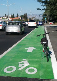 I rode in my first green bike lane, which popped up this week on a busy, freshly-repaved thoroughfare.
I saw deer and bunnies, and so many birds—including the low-flying Canada geese that barely cleared my head tonight.
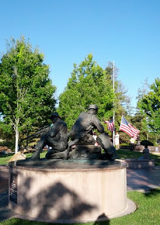 I discovered the namesake memorial to fallen soldiers at a community park, and watched some scouts learning to handle the American flag.
 I smiled and said “Good morning!” to lots of solo walkers, and paused to wave to the engineer running a beloved steam locomotive through a local park.
 I swept up broken glass, alerted maintenance crews to graffiti and spent firecrackers, and reported the occasional wayward gbike that had left the Google campus.
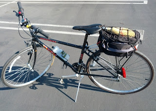
I wore out the rear tire on my commute bike, down to the threads, after some 7,900 miles over 7 years. The front tire carries less weight and is still going strong. (Continental Sport Contact, if you were wondering).
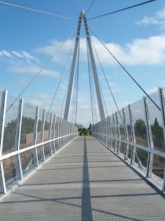 I realized that a shadow cast by the rail on our soaring bike bridge is a sundial, of sorts. The days are unmistakably growing shorter.
I burned an estimated 28,000 Calories, which I offset with pancakes, French toast, bacon, and plenty of dark chocolate. (OK, yogurt and fresh fruit, too.)
Factoring in some recreational excursions, I managed a 7-day streak of daily rides totaling 219 miles.
Counting all rides, I tallied 239 miles in my best calendar week. For the month: 902 miles, with more than 27,000 feet of climbing.
I spent about 77 hours bicycling. Sure beats sitting in traffic.
Along the way, I crossed paths with three cyclists I know. One ride buddy went out of her way to join me on the morning commute, just for fun.

I saw deer and bunnies, and so many birds—including the low-flying Canada geese that barely cleared my head tonight.


I wore out the rear tire on my commute bike, down to the threads, after some 7,900 miles over 7 years. The front tire carries less weight and is still going strong. (Continental Sport Contact, if you were wondering).

I burned an estimated 28,000 Calories, which I offset with pancakes, French toast, bacon, and plenty of dark chocolate. (OK, yogurt and fresh fruit, too.)
Factoring in some recreational excursions, I managed a 7-day streak of daily rides totaling 219 miles.
Counting all rides, I tallied 239 miles in my best calendar week. For the month: 902 miles, with more than 27,000 feet of climbing.
I spent about 77 hours bicycling. Sure beats sitting in traffic.
July 30, 2014
The Broom Wagon
Years ago, on the other coast, my co-workers and I would enjoy lunch al fresco during the warmer months. We had our favorite places: a magnolia-rimmed plaza with a huge fountain, a tree-shaded lawn, even the local cemetery. We would always leave a place cleaner than we found it—removing litter that had been thoughtlessly tossed by others.
As I climbed the ramp to the second bike/pedestrian bridge on my route on Monday, a wide swath of shattered glass glistened in the morning sun. There was no way to ride around it. [Lovely.]
I meant to alert the town's Public Works Department, but that slipped my mind until I faced my second trip through the field of glass on my way home. After picking a half-dozen fragments out of my tires, I filled out their online form.
I meant to pack a small broom on Tuesday morning, but forgot. I grimaced on my third trip through the glass. The Public Works folks dispatched a crew to sweep up, and I was relieved that I would have a clean ride home. [Not.]
In sweeping the ramp, they managed to disperse the glass over a wider area (and remove little or none of it).
 On Wednesday morning, I tucked a well-worn whisk broom under my cargo net (a recent acquisition). I parked my bike on the ramp and proceeded to sweep both sides of the path, from the center line to the edge. Shards of clear glass were scattered over some 15 feet of the ramp.
Five passing cyclists thanked me.
One pedestrian was impressed and stopped to chat.
It was a slow, tedious job with my little broom, but my calculation had been more selfish than selfless. Spend 20 minutes to sweep the bridge once, or spend time every day picking glass out of my tires (or worse). Dealing with just one punctured tube would take more time.
I remembered to send some polite feedback to the Public Works Department. They needed to know that their clean-up attempt was not only ineffective—it made matters worse. And I wanted to make sure they didn't re-distribute the glass the next time they swept the bridge.
They got the memo. On my way home, the glass was gone, gone, gone!
As I climbed the ramp to the second bike/pedestrian bridge on my route on Monday, a wide swath of shattered glass glistened in the morning sun. There was no way to ride around it. [Lovely.]
I meant to alert the town's Public Works Department, but that slipped my mind until I faced my second trip through the field of glass on my way home. After picking a half-dozen fragments out of my tires, I filled out their online form.
I meant to pack a small broom on Tuesday morning, but forgot. I grimaced on my third trip through the glass. The Public Works folks dispatched a crew to sweep up, and I was relieved that I would have a clean ride home. [Not.]
In sweeping the ramp, they managed to disperse the glass over a wider area (and remove little or none of it).

Five passing cyclists thanked me.
You're a very good person!
It was a slow, tedious job with my little broom, but my calculation had been more selfish than selfless. Spend 20 minutes to sweep the bridge once, or spend time every day picking glass out of my tires (or worse). Dealing with just one punctured tube would take more time.
I remembered to send some polite feedback to the Public Works Department. They needed to know that their clean-up attempt was not only ineffective—it made matters worse. And I wanted to make sure they didn't re-distribute the glass the next time they swept the bridge.
They got the memo. On my way home, the glass was gone, gone, gone!
July 26, 2014
Up on the Ridge

Some of our club members headed for Henry Coe State Park. Such a long, exposed climb was not enticing; a frolic in the redwoods sounded much more appealing.
Our convivial band of riders hung together pretty well, with faster riders doubling back at times to check on the slower folk.
There was no drippy fog to cool us, but ample shade as we headed into the Santa Cruz Mountains. We dipped over the summit before returning to the ridge, and found a bit of a breeze as we traced our way south. Heading back, we looked down at a freeway clogged with cars heading toward the beach. Descending toward the valley, our last mile felt like riding toward a blast furnace.
At a comfortable pace, we climbed some 3,205 feet over 39 miles. My backyard thermometer topped out above 98F. Nothing that a bowl of ice cream and a cool shower couldn't fix.
July 20, 2014
Lassen Volcanic National Park


Our cooler packed with ice and sandwiches from the local market, we headed for the park on some roads that were familiar from yesterday's bike ride. First hike: Lassen Peak. Regrettably, our visit did not coincide with one of the days when the trail to the summit is fully open. We enjoyed our climb nonetheless. I made it to the turn-around point at Grandview, which was just below the level of the remaining snow fields (elevation: ~9,400 feet). Fellow hikers, who have frequently visited the park, told me that this was the first time they had seen Lake Helen without a surrounding ring of ice.

And you would be wrong.


July 19, 2014
Burney Falls

That's right: After biking more than 86 miles in the heat, we went hiking. [Crazy people.]
There is a parking lot near the falls, and it is safe to say that most visitors don't venture much farther than the overlook, or the vista point near the base of the falls. We followed the Falls Loop Trail counter-clockwise, descending to the base of the falls before heading downstream, across some bridges, and then climbing back above the falls. Hiking 1.2 miles in the cool canyon felt great. [Seriously.]

Subscribe to:
Posts (Atom)


