December 27, 2013

Raise High the Floor Boards

An overcast sky looms above the waters of Barnegat Bay
Many shades of gray, a winter's day along the bay.

Bay Head Yacht Club building supported on steel beams and stacks of wood.
This Old House has run a series on the rebuilding process at the Jersey Shore. After watching an episode where they ever-so-slowly used hydraulic jacks to lift a home above its foundation, I had the opportunity to take a close look at a similar (but grander) project.

Overall view of the Bay Head Yacht Club building, raised above ground.
The Bay Head Yacht Club building was built a long time ago, at the water's edge (naturally). Hurricane Sandy was not kind to the structure, which now must be raised. But wait, you say: that building is at least a hundred yards from the water.

Not only did they lift that massive building, with its two brick fireplaces and chimneys—they shifted it north, onto the (former) tennis courts.

Crane and drill installing pilings at the water's edge.
With an enormous crane and drill, engineers are driving helical piles into the ground to create a new (higher) footing for the clubhouse.

Man may win this battle, but one day the sea will prevail.

December 14, 2013

Hazy Shade of Winter

Pasture and distant hills viewed from top of Altamont Road
Leaves are brown, no patch of snow on the ground. No patches of ice, either, though we were on high alert—especially when crossing the occasional wet streak across the road. Some higher stretches of pavement were white, as if they had been salted. Could it be?

Atmospheric conditions have been unfavorable for air quality over the past week; today was our seventh consecutive Spare the Air Day. Wood burning is prohibited, to keep the airborne particulate count down.

A handful of riders turned out for today's adventure, which was designed to be short and not-too-challenging. My day was carefully orchestrated: bike, donate blood, and complete a bunch of holiday-related errands with adequate time to get spruced up for a holiday party in San Francisco.

The frosty air warmed quickly to a more hospitable temperature. Climbing Moody Road was less painful than I remembered, and my body did not balk when my heart rate hovered around 180 bpm for an extended spell. The real treat was Altamont, which afforded a sweeping view of a small valley from the top. Although it runs nearly parallel to Moody, the road is completely different in character.

For the day, a short 20 miles with some 2,100 feet of climbing. Just enough.

December 13, 2013

Red Letter Day

Bronze quail statues with red scarves at Mary Avenue bike/ped bridge
On some forgotten day this year, I decided that a goal for 2013 should be to beat my previous record for number of bicycle commutes (34, in 2007). In the past three years, I had gotten lazy; most days, it is oh-so-easy to find a reason not to get up early and climb on the bike.

The more often I rode, the easier it became. It was habit-forming. There were a few weeks when I managed to bicycle-commute four days out of five, which helped to offset three months of slothfulness (not even one ride to work during the months of January, February, and March).

The least palatable way to get to work is to drive. In heavy traffic, driving can take nearly as long (or longer) as biking it.

Most days, I rely on a commuter shuttle bus. Door-to-door, that trip also takes nearly as much time as biking it; but it allows me to extend my day by getting some work done en route.

Today was a special day, and not only because I discovered hand-made woolen scarves adorning the California Quail statues.

Today marked my 52nd bicycle commute of the year. Some 1,895 miles pedaling to (and usually, from) the office.

December 8, 2013

'Tis the Season

Brown hills, green trees, mossy fence posts
Winter in the Bay Area hardly conjures up visions of Frosty the Snowman. For the past week, however, we have been in the icy grip of an Alaskan air mass. Pipes are bursting, delicate plants are turning to mush, and self-generated wind chill on a bicycle holds little appeal.

With the thermometer registering below the freezing mark, it would be an ideal morning to snuggle under a warm comforter. Except that I had gamely volunteered to lead a ride for the club.

Who would show up on such a morning? Perhaps no one, in which case I might simply declare victory after the first hill, and skip the next four.

Stone bridge, palm tree, Mt. Hamilton in the distance
Oh, me of little faith. Six people turned out for my ride; two left home early enough to bike to the start. In the land of palm trees and surfboards, there are some hardy Californians. Okay, it's not Minnesota ... but the weather is freezing and we all dug into our stashes of cycling gear for the heavy-duty stuff.

It was a day not to head for the Santa Cruz mountains, where the Christmas tree farms are bustling. I chose to head across the valley to the eastern foothills, for roads that were mostly well-exposed to the sun. We tackled the steepest climb first, followed by a series of mellow (mostly short) hills.

I was apprehensive about the cold; I have to admit, though, that it was really a pleasant day to ride. I have certainly been colder, on the bike. Whenever we stopped to regroup, my dark side chilled down fast. (Nothing that couldn't be fixed by a judicious pivot toward the sun.)

The little hills added up. It did not feel like I had climbed 4,215 feet over 36 miles. Cold therapy is good for muscle recovery.

November 30, 2013

Welcome to Our World

Hills on the back side of Sierra Road, with Santa Cruz mountains rising above the mist in the valley
It was a day to escape the bustle of civilization, to climb out of the valley and connect with the natural world. Below the mist, downtown San Jose was less than 10 miles away. I spend my weekdays overconnecting with technology; this is how I spend my weekends.

We headed straight up Old Calaveras Road. [And I do mean straight up.] The chilly air burned our lungs and our hearts pumped hard to warm up our muscles. Instead of the traditional right turn at the road's end, we took a left to explore some new terrain. Everyone agreed that Sandy Wool Lake was a scenic reward for that tough climb, and a much nicer place to regroup. Alison taught us about the origin of hang gliders as we watched fliers hauling their wings up the slope. Challenge: find a paraglider in that photo.

There were three courses on today's menu, 4,400 feet of climbing (and descending) densely packed into 28 miles. One rider's appetite was sated by the appetizer, Old Calaveras. Four riders had their fill after the soup course, Felter. The rest completed the main course, Sierra; a few had time for salad (assorted sections of Calaveras). Still hungry, two riders tackled Welch Creek for dessert.

Assembling at the start, one rider remarked that there were no flat sections on today's ride. True, I admitted; but there are downhills. One rider was apprehensive about descending Sierra, and thought it was silly to turn right around and climb back up. Well, there you are, right in the neighborhood, I replied. How could you not climb Sierra?

As it happened, a few of us were in the right place at the right moment on Sierra. However compelling the view, it is rare [exceedingly rare] for me to stop on a descent. At 22 mph, something very special came into view with enough space for me to come safely to a stop.

The smallest calf I had ever seen was right next to the fence. Mom watched me, but was unconcerned. The newborn was as fascinated with me as I was with him. Mom had already cleaned him up, but he was clearly hours old—unsteady on his feet, with a trace of umbilical cord still dangling. Welcome to our world, little one.

November 22, 2013

Take a Peak

Anderson Lake, Morgan Hill, CA
On the long climb, I was passed by a cyclist with a catchy phrase on the back of his jersey. Emblazoned with the symbol for California State Route 89, the encouraging words were “Take a Peak.” That would make a fine slogan for next year's 
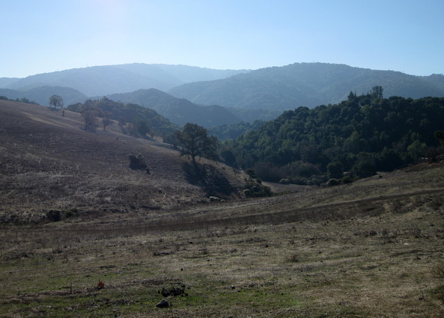
Low-Key Hillclimbs, I thought. Clear skies gave us clear views of three regional peaks: west to Mt. Umunhum, northwest to Mt. Hamilton, and south to Fremont Peak. Today's destination was Henry Coe State Park, a ridgetop undistinguished by name, near the Calaveras Fault. This is California's largest state park, but exploring it takes commitment: the Visitor Center is at the western edge. The rest is wild land.

The road to the park is wild enough. I spotted an acorn woodpecker inexplicably tapping at a cable splice case, a small covey of California quail, and a bevy of peafowl encircling a pickup truck in someone's driveway. Deer scampered away as I approached, but I nearly overlooked the sly young coyote trotting alongside the roadway. He rounded a bend ahead of me and vanished.

Bear balancing gifts on a ball, Fantasy of Lights
My evening was devoted to a different sort of peek: for the first time, the local Fantasy of Lights was opened for a one-night-only walking tour. People have requested this access for years, and the county parks department decided to give it a try. As a volunteer, my role was to keep people safe: on the paved road, off the dark trails, and away from the lighting displays. Bundled up for the chilly five-and-a-half hour shift, I began to regret my decision to help.

The parks department had no idea what to expect, though some 500 people had purchased tickets in advance.

There were couples strolling hand-in-hand. Multi-generational families. Children in strollers and wagons, including one three-car Choo Choo Wagon, complete with lights. A couple spontaneously waltzing to a Christmas song.

“Hi, sweetie. I know it's really hard, the lights are so pretty, but please don't touch them, okay?” That line worked well. The dad looked at his toddler and laughed. “Busted!” he told her. “She's going to tell you that you can't go that way,” another dad told his son. I smiled, “Right, you can't take the trail tonight.” [Parenting by proxy is popular.]

I chose one of the less glamorous zones; only two of us volunteered to staff it. One hour in, I thought “this is going to be a lo-o-ong night.”

Fantasy of Lights, American flag display
The bridge was a busy spot for photos. It reminded some of fireworks; others, of a counter filled with colorful bins of candy. What surprised me most was the popularity of another display: The American Flag. Here I am, stationed next to a symbol unrelated to the holidays. There are tunnels of light, trains and snowmen, animated gingerbread cookies jumping rope, toy soldiers and elves and penguins, even dinosaurs. The flag seemed out of place.

I was wrong.

“The American flag!” kids squealed as they ran toward it. At least two of them put their hands over their hearts and launched into the Pledge of Allegiance. “Take a picture of the flag with grandpa!”

We are a nation of immigrants. Tonight I was reminded that this symbol has a deep significance to many. Five and a half hours well-spent.

November 2, 2013

The Old Stage Road

Five minutes. Five minutes till the next loaf of Artichoke Garlic Herb bread comes out of Arcangeli's oven. My fellow rider and I finished our PB&J sandwiches. He looked at me. “I think it's been five minutes, now?” and returned with a steaming loaf for all of us to share.

Bliss.

Several riders were tentative. They had ordered big sandwiches. “Try some,” we insisted. [I was not disappointed to eat more than my fair share.]

Among the notices posted in the picnic area behind the market was a thank-you to their customers: bicyclists, motorcyclists, and whale watchers—all are welcome.

The San Gregorio House
The ride had been colder than I expected, and the marine layer seemed too stubborn to burn off. For the first time, I had noticed the historic plaque (courtesy of the Clampers) next to a ramshackle building across from the General Store in San Gregorio. As we were traveling along a portion of the old Stage Road, it was not surprising to find that this had been a stage coach stop. Formerly an inn, built in 1865 and rebuilt in 1902, it is now private.

The marine layer finally retreated as we headed for Haskins Hill. Earlier, a rider had asked whether the climb would be steep. “No,” I said. Then I thought to ask what she considered steep. Some shot ahead on the flats, later to dismount and walk up the last stretch of Haskins (average grade of 7% over 2 1/4 miles). I thought back to the first time I had climbed this hill, with a different club. Abandoned by the leaders, a few of us had retraced our path to the start when we learned that the planned route was blocked by downed wires. The climb was a struggle for me, that day.

It was easier than I remembered. Thirty-one miles with some 2,300 feet of climbing. I should ride this loop more often—for the bread, alone.