Showing posts with label hiking. Show all posts

March 31, 2025

March Meanderings

A fanciful mural near Almaden Lake appeared some time ago (mirrored by another, across the road). Biking past on a cloudy day, I realized conditions were ideal for capturing it without shadows.
I returned to Rancho CaƱada del Oro for my first hike of the month, the usual 4.1-mile loop. Expecting a flooded trail crossing, I tried (unsuccessfully) to lead our group on a parallel path. Fortunately, the crossing was passable. Not up for the extended version of the hike, a couple of like-minded souls stayed with me.
A week later, I took advantage of another opportunity for a docent-led, 4.8-mile loop in Sierra Azul. Clear, sunny skies this time!
Skies were overcast when I joined a friend's group for a hike up Mission Peak. Given the conditions (and the lack of a view), I was surprised how many people were snaking their way to the summit. I don't recall crowded trails when I last hiked here (almost 20 years ago!), but that was a different trail. I was carrying a loaded pack then, training for a hiking tour, and likely didn't aim to reach the summit. I do remember sharing the trail with cattle.
I stopped a few feet shy of the summit today, unwilling to join the long queue of people waiting for their turn to cavort for photos with the post at the top. (Whatever.)

A challenging hike for sure, with more than 2,000 feet of elevation gain over 6.5 miles (out and back).

Open space preserves, county parks, city parks ... we are fortunate to have so many places to explore in the Bay Area! When you think of a city park, a wild place like Alum Rock is likely not what you have in mind.

We reveled in the green hills and enjoyed some early wildflowers on our 6-mile, double-loop hike.

In the spirit of giving back, I signed up for a volunteer project removing invasive French broom from some land in Sierra Azul. I wasn't sure whether I could make a meaningful contribution, but the coordinator assured me I would be useful.

Then I met the Weed Wrench. And the oh-so-satisfying sound of thick taproots being wrenched (literally!) from the earth.

This being another closed section of Sierra Azul, it was unknown to me despite the countless times I've cycled past on the road below. A recent project to clear non-native, fire-hazard eucalyptus trees from the property afforded us a clear view of Lexington Reservoir and the ridge beyond.

Unaccustomed to sharing his territory with humans, a tom turkey paid us no heed as he strutted his stuff.

Rainy days have thwarted many plans for me to bike this month, so I was disappointed when my hiking buddies bowed out for the last day of the month. Looking at the forecast, and the weather radar, I reckoned an afternoon hike would be dry. I settled on a loop through familiar terrain in Almaden Quicksilver, a route that's convenient and popular for so many hikers.
I'd never seen those trails so empty.
As I made my way along the usual 4.8-mile loop, there were buttercups and butterflies, deer and quail, a bald eagle and Henderson's shooting stars. I met another hiker as a smattering of raindrops trickled down.
As I headed home, my windshield wipers got busier. I made it into the house just before the deluge ...

February 28, 2025

February Forays

February started with a 4.3-mile hike in an otherwise closed area of the Sierra Azul Open Space Preserve, a privilege I rarely skip whenever this turns up on the calendar of docent-led activities.
The forecast wasn't great, but I donned my rain jacket and smiled when a rainbow sliced through some clouds.
Wet weather, this time of year, brings out the newts (and many were sighted). I inadvertently captured a group selfie, trying to get a ground-level close-up. This also had the effect of stopping the newt from moving forward, seemingly transfixed (or puzzled?) by the image on the screen. Are newts self-aware?
We had such a nice day for another hike in Sierra Azul that I convinced a couple of friends to go just a little bit farther uphill (6.7 miles, up and down). Along the way we'd passed a stunning chapparal currant bush in full bloom.
A friend invited me along for a hike on the other side of the Bay, in Coyote Hills Regional Park. This was fresh territory for me, as it's more straightforward to explore the shoreline on the west side of the Bay. Late winter lighting made for some moody reflections.
Our 4.1-mile route was mostly flat (except for the steep bits)!
The domes of Lick Observatory atop Mt. Hamilton were visible above the clouds when we tackled a 5.8-mile loop in a section of Almaden Quicksilver that we visit less frequently.
But it was a visit to the Sierra Vista Open Space Preserve that delivered my favorite image of the month, as the timing and location for the start of our 4.5-mile route deposited us at the edge of the clouds.
Of course, there was some cycling, too; including one special ride to connect with old friends. The guest of honor was a much-loved cycling buddy recovering from some serious health challenges. His t-shirt (“GRUMPA: Like a regular grandpa, only grumpier”) couldn't have suited him less! But it was funny.

January 27, 2025

January Jaunts

I visited familiar parks in January, sometimes exploring new (to me) trails.
There were some seasonal surprises at Picchetti Ranch, like this lovely fungus that was lit just so.
Our group's usual loop in Almaden Quicksilver afforded a view clear across the valley.
We started our loop through Santa Teresa County Park from the historic ranch (a first for me). I've often watched others hike uphill from there; it's unrelentingly steep for most of the first mile.

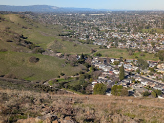
It was starkly clear where the edge of suburbia meets the untamed hills.

For our last adventure of the month, we hiked a near figure-eight in Calero County Park.

We passed the Calero Bat Inn (but saw no bats, who were presumably asleep).

It was another picture-perfect day, and we pretty much had the trails to ourselves.
We passed a stone fixture, apparently spring-fed, for thirsty four-legged creatures. (Horses are permitted on these trails).
I'd harbored some doubts about how I'd fare today (longest hike to date, six miles); whenever others paused, I would keep going. Otherwise, I knew I would fall behind.

Good strategy.

December 25, 2024

Ho Ho Ho

Continuing our tradition of a Christmas Day hike, a friend and I headed for some unfamiliar terrain.
I thought the area would be mostly exposed and thus relatively dry. [Wrong on both counts.]

I'm no longer surprised that we're not the only holiday hikers. Though sadly, two boys were tearing up the slick trails on their shiny new electric bikes. [Sigh.]

I was prepared with a route when my friend suggested that we explore the Heintz Open Space Preserve; I'd mapped out a loop some time ago, but it was too short to be interesting for my regular hiking pals. There is scant information online about this preserve (and the adjoining Santa Rosa Open Space Preserve). Trail markers were nearly non-existent; without GPS, we would have been confused (at best) and likely lost.

There is a curious history to this place, part of a former estate given to the town of Los Gatos. An interpretive sign told the story of the property's miniature railroad before we passed the filled-in tunnel entrance.
Past the loop shown as the end of the Vista Trail, we explored a distinct trail that doesn't appear on maps of the area. Not knowing where that would lead, we turned back after a short distance.

We covered a little over three (muddy) miles for my last planned hike of the year, grateful for my hiking poles and for the generous gift of this land.

December 8, 2024

Infinite Wonders

Couldn't pass up a chance to join docents leading a hike in a closed section of the Sierra Azul Preserve. Although I've joined other hikes in this area, today we would follow an extended (figure-eight) route.
The meadow was already sprouting green after a recent controlled burn, and a fire break that had been plowed along one edge offered a new vantage point.
Thanks to trail-clearing work, we were able to enjoy a path above a steep canyon. Rocks had since tumbled down, in places; keeping this trail open will likely be an ongoing challenge.

The toyon's red berries provide a festive splash of color this time of year.

And just as I was thinking that there is little to discover as winter approaches, a lovely layered fungus set me straight.
We were happy to be hiking at an elevation high enough to rise above the winter smog in the valley. The clouds had shifted by the time we completed our five-mile route, leaving the pond to mirror blue sky rather than gray.
No better way to spend the day!

November 18, 2024

While the Sun Shines

With my legs complaining during yesterday's hike, I wasn't sure I would want to hike today, and I certainly wasn't up for the longer route planned. I woke up with a mysterious backache. All I did was ... sleep?

But the thing is, we're about to get hammered with some rainy weather.

Our leader chose the loop I led a few months ago, but in the clockwise direction. We paired off: one friend joined me (barely visible in the photo above), and one joined our leader for the extended version. Something for everyone: the fast hikers on the longer route, and the slowpokes on the shorter edition.

Soon the hills will be green again.

November 17, 2024

Fall Color

Expecting little color in the landscape this time of year, I was surprised to find something bright—a flower that was new to me.
I had explained to my hiking companions that today's trails are reliable for wildflower viewing in the spring; turned out that the serpentine sunflower is also at home in this soil, later in the year.

Cloud cover was building as the day wore on; there was little wildlife to see, perhaps due to the cool temperature. Cattle grazed nearby, separated from the trail by barbed wire. We were treated to the sight of a nursing calf—not a common thing, for us.

As we circled toward the end of our 4.6 mile loop, we passed through an area busy with birds: acorn woodpeckers, California quail, lesser goldfinches. As we climbed the trail that would return us to the parking area, a large bird swooped overhead toward a tree. I couldn't be sure that it perched, or that I could find it, but my camera zoomed and delivered: a red-shouldered hawk.
The presenters at Raptor Fest yesterday had suggested that the area was popular with local raptors, and here was one—reinforcing the importance of preserving contiguous (or near-contiguous) tracts of wild open space.

November 4, 2024

Hints of History

Today's hike introduced me to a section of Almaden Quicksilver Park that I had not yet explored.

There are a few odd boulders that pop up around this area. Regrettably, I know nothing about geology. This specimen has an impressive fissure, though it didn't appear likely to split anytime soon.

The skies were clear, thanks to some recent windy weather. The trails gave us views of the Santa Cruz Mountains and Mt. Umunhum to the west, and
eastward across the valley to Mt. Hamilton and the Diablo Range.
Although some folks jumped ahead, the group mostly stayed together.

While it might seem obvious that you shouldn't stray off the trail to explore the crumbling remains of old cabins, warning signs were posted. One included a special note that hantavirus has been found in the park's rodents. That was a warning I'd never encountered, until now; all the more reason to stay clear of old buildings (and always read signs)!

The April Tunnel Trestle still stands, but the years have taken a toll. Without restoration, sections seem likely to collapse. It's an impressive relic, for now.
After hiking six miles I was ready for the sandwich I'd packed. This time of year, the picnic table's well-intentioned pergola cast a shadow on the ground, several feet away. It was surprisingly warm for a November day; four of us made like birds on a fence and perched side-by-side, our backs to the sun.

Now that the mining museum has reopened (though not daily), I should plan a visit. Some rainy day, this winter.

October 13, 2024

Can't You Read the Signs?

As I pulled on my hiking boots at Bear Creek Redwoods, a couple climbed out of their pickup truck with a small dog. Thinking that dogs weren't welcome at Midpeninsula's open spaces, I was surprised—and figured that I was mistaken.

Yes. And no. (They're welcome at some preserves, but not this one.)

Fog touched the treetops on the hills, but our trail wouldn't climb that high. I was glad when my former teammates suggested this preserve for our hike today; at this time of year, the forest is an especially welcome alternative to the dry hills. One of the guys was hiking with us for the first time ... along with his friendly dog.

Busy chatting, we passed the usual (brown) sign at the trailhead. Do this, don't do that ... Of the many icons and other text on the sign, what caught my eye was the hiker (permitted, of course) and weapons (not allowed). All of us focused on the bright yellow sign, beneath, about mountain lions. I also noticed a temporary sign announcing that the Madrone Knoll trail was closed, but we weren't planning to hike that anyway.

None of us noticed that dogs are, in fact, not permitted. None of the hikers we passed said a word.

But a ranger was lying in wait, his truck tucked into a spot just off the trail. And he was not pleased. Our colleague got a ticket (not a warning) and was sternly told to “leave immediately.” (We were on the return leg, at that point.) The ranger insisted that we had passed 11 “no dogs” signs. [Not really. Paying close attention, we found four or five that we had indeed overlooked; others are likely placed at paths we didn't follow.] Maybe a couple of the small, dog-specfic signs would be more eye-catching if they were, say, black and white?

Lesson learned. Read the signs, always.

September 9, 2024

Quarrying Biodiversity

I'd been surprised when a friend suggested Saratoga's Quarry Park for a future hike. I've passed it many times, never giving it a closer look. I thought it was just a quirky historic town park.
I had no idea that there we'd find a trailhead for the “Saratoga to the Skyline Trail,” which aligns with the Skyline-to-the-Sea Trail: altogether, 36.6 miles to the Pacific Ocean, per the trail marker.
When my hiking companions charged up the hill at a pace I couldn't sustain, I settled into my own pace. A couple said they often hike here, and others were also familiar with the trail. The sights were new to me, and I was in no hurry.
There were explanatory placards along the way, but I skipped them to avoid falling even farther behind. Even then, one friend turned back to scout for me when they realized I'd been out of sight for a while. They likely assumed I was stopping often to take photos of whatever I fancied, playing amateur naturalist. And although that had not been my intent, that was how my trek turned out once I decided that I couldn't keep up with the group.
Consensus was that an open area with a trail fork to private property was a natural turnaound spot, for a total distance of nearly seven miles, with some 1,200 feet of elevation gain.

Alone with my thoughts, and the sights and sounds of the world around me (Was that a rattlesnake I heard?), I concluded that I'd found my limit. I'm more of a contemplative hiker than an aerobic one, and I need to factor that into future group-hike decisions.

September 3, 2024

A Trail Less Traveled

Two days ago, I'd introduced a few of my former teammates to an oft-visited section of Almaden Quicksilver County Park that offers a good mix of tree cover, open vistas, and a nice view of the Guadalupe Reservoir. This time of year, I'm less likely to be distracted by the flora and fauna (as the landscape grows ever more dry). We spotted a couple of deer almost immediately, much to everyone's delight.

Most plants bloom during springtime, but I'd learned that some have found an evolutionary edge by having less competition for pollinators in a later season. The hayfield tarweed is in full bloom now, but something else caught my eye that day. A tiny, delicate flower on spindly stems. Had I seen that before? From the blurry photo I managed to capture, I later learned it was a rare plant. One specimen. A veritable needle-in-a-haystack, for me.

And thus it was that I returned today for a closer look (and a better photo, which I won't share here in the best interests of the plant).

To shorten the loop and mix things up a bit, I decided to introduce myself to a different trail. For a while I thought I might not cross paths with other people; the trail seemed less trodden (and narrow).

Woodland skippers were having a (hay)field day with the tarweed; as usual, I was focused on what I could see nearby. When my gaze wandered uphill, I was surprised to find two pairs of eyes focused on me.
With an early start and having shortened the loop from five miles to two, I was done before the day heated up.
And despite having crossed this bridge on so many hikes, I finally noticed that it's a century old!