August 19, 2017

Redwood Rain

I stepped out of the car, just a few miles from home, and was surprised by the chill. [Uh-oh.] I didn't expect to need an extra layer. Micro-climates. I pulled out my arm coolers, which I'd brought for extra sun protection. They would have to do.

Hazy view of Mt. Umunhum and Mt. Thayer from the west, Santa Cruz County, CaliforniaI'd caught a glimpse of thick fog in a sheltered valley on the drive up to the start, and hoped we would stay above it. [Nope.]

By the time we reached Summit Road, the fog was thinning but still blowing sideways from the coast. It looks like steam ... but it's cold. And of course, wet. In the forest next to the road, there were pockets that sounded like steady rain as the condensing fog dripped from the branches of the redwood trees.

“If I ever move away from here, it's the redwoods I'll miss most,” one of our riders remarked. How very fortunate we are, to be cycling through the redwood forest just a few miles from home.

The surface of Highland Way continues to deteriorate, battered by last winter's storms. Slides have reduced it to one lane in a couple of places, and some fresh boulders are perched at the road's edge. This is not a place to linger when there is any likelihood of earth movement.

We made our way up to a high point on Loma Prieta Road. The agricultural fields around Watsonville were just barely visible, if you knew where to look; Monterey Bay and the peninsula were obscured by the marine layer.

Scorched slopes of Loma Prieta, Santa Cruz County, CaliforniaAnd as close as we were to their peaks, we had hazy views of Loma Prieta and Mt. Umunhum. Only then did I realize that there was another layer above the fog, a thin layer of smoke. From where, we wondered, as we looked at the hillside scorched by last summer's Loma Prieta blaze.

37 miles, 3,535 feet of climbing. For an out-and-back route, what goes up must also come down. Translation: That's a lot of climbing over a short distance. I suffered.

August 12, 2017

Velo Vittles

Orange and blue canopies shade the diners, San Jose, California
The main event today was not the climb (up Highway 9); it was lunch.

For a few years, one of our club members has hosted a barbecue to raise funds benefiting the National Multiple Sclerosis Society. He captains a team for Waves to Wine each fall.

Waves to Wine was the first charity bike event I supported, back in 2003 (as the stoker on a recumbent tandem). I learned that I could raise funds successfully, earning a “Champagne Club” jersey straight away. I returned on the tandem in 2004 and transitioned to riding solo in 2005.

The event had a friendly, homespun vibe those first three years; the logistics were simple, with two loops based out of Santa Rosa. Big changes came in 2006: complicated logistics, a move away from the fabulous old routes, and disorganized execution. I still support the cause through my friends who do the ride, but switched my riding allegiance to a new charity (Best Buddies).

pep in her 2004 Waves to Wine Champagne Club jersey, where CA 116 meets Highway 1 south of Jenner, California
This year was the first time I attended Craig's barbecue. Of course, I donned my favorite Champagne Club jersey (circa 2004) for the occasion.

I was the first patron to arrive; a bit early for lunch, but cyclists do get hungry. Grills were lined up along the edge of the driveway, and a pair of canopies from the MS Society shaded the tables. I chatted with a mechanic who has volunteered regularly at Good Karma Bikes (alongside our host), as well as friends and neighbors who stopped by. One guy's eyes grew wide when he heard I'd cycled up Highway 9 on my way to lunch. “I've scuba dived, I've dived for abalone ... I've never biked up Highway 9!” [More dangerous than free-diving for abalone? I beg to differ.]

Highway 9 isn't too crazy, even on a summer weekend, if you get an early start. On the way down, a Porsche trailed me patiently enough until it was safe to pass. Seemed fair enough, as we were both traveling in the neighborhood of the speed limit. (Um, roughly.)

One plate of ribs, beans, salad, corn muffin. Plus fresh lemonade. Thus refueled, I pedaled on home. Thirty miles with 2,580 feet of climbing—no map to share, as my GPS took a nap along the way.

August 6, 2017

Feathers and Friends

There was at least one club member who was disappointed to miss last week's outing. And the birds are still there, so ... let's do it again!

Cyclists heading north on the Bay Trail, Sunnyvale, California
Another strong turnout, including a couple of people who rode with us last week. Plus four biking friends who were curious enough to come over from the East Bay.

Snowy egret near the water's edge, San Francisco Bay tidal pond, Mountain View, California
This week, it was windy along the bay. Really windy. Which meant that most of the birds were hunkered down to hunt in coves where the levees offered something of a wind break. There were a couple of snowy egrets close to shore. The wind helped ruffle some feathers, giving us a look at the distinctive plumage that adorns the back of a snowy egret's head.

Red-tailed hawk perched on a fence post behind Moffett Field, Mountain View, California
Behind Moffett Field, this red-tailed hawk wasn't too concerned with us. “Wish I could get a better picture, if only it would turn around,” said one rider. “The bird needs to face into the wind, otherwise think what would happen with its feathers,” I suggested. Just as I'd put the camera away [of course], a brazen seagull swooped down over our heads to harass the hawk, leading to an aerial bird fight. (Just threats, no victim ... today.)

Last week I sensed that people would have preferred to head straight back after lunch, so this week we visited the Garden of Tasty Treats first. That worked out well, people were excited to pose for photos with their favorite droids. And as much fun as that can be, the birds are a tough act to follow.

Black-crowned night-heron perched on a tree branch, Mountain View, California
One of the Black-crowned Night-Herons was out of the nest, perched on a branch for all to admire.

Snowy egrets feeding their nestlings, Mountain View, California
The rookery more than made up for the meager sightings along the Bay. People laughed and rooted for some fledglings that were flapping around, testing their wings and making it a few feet off the ground to a window ledge. Commotion in one nest drew our eyes upward, where we had a clear view of snowy egrets feeding their young. I passed around my binoculars for everyone to get a closer view.

National Audubon Society logo on the back of the designer's bike jersey.
I was explaining how the National Audubon Society came to be, protecting these birds from being hunted to extinction. “Their logo features an egret,” I said. “Mike designed that!” exclaimed one rider, proudly. [Say what?!] We had a bona fide celebrity on our ride. The guy wearing the jersey that was covered with logos (for brands that you would recognize) was the graphic designer who created them!

For me, 52 miles with 1,000 feet of climbing. (For everyone else, 26 miles with 340 feet of climbing.)

Much to like about this route, if I do say so myself!

July 30, 2017

For the Birds

Riders on the trail, Sunnyvale, California
The results are in: my route was a resounding success!

Twelve people joined me for the inaugural ride—including one rider on a folding (!) recumbent. “We'll all stay together,” I promised (wondering how I would keep track of such a large group).

They were a great bunch, though; when one rider flatted, another jumped in immediately to carry out the repair. “I like to do this,” he insisted. The rest of the group chatted away, and one rider pulled out a bag of grapes to share.

Seven Snowy Egrets, two American Avocets, and five unidentified birds, at the edge of San Francisco Bay, Sunnyvale, CaliforniaIn the ponds along the Bay Trail, we saw more egrets (and American Avocets) in one place than most people had ever seen. You'd think they were as common as sparrows.

Haze spoiled the view of the Diablo Range across San Francisco Bay, but the waters reflected a deep blue sky.

Snowy Egret with two chicks in a nest, Mountain View, CaliforniaIt's getting late in the season for the rookery, but we were not disappointed. Two fuzzy chicks were visible in their nest, with their attendant parent; they'd hatched a couple of weeks ago. Everyone was surprised to see these graceful birds nesting in the branches of sycamore trees; with their broad wingspans, it all seems so improbable. One rider remarked that he could stay there for hours, watching them.

Both Snowy and Great Egrets nest here; I explained how they were nearly hunted to extinction (for their fancy feathers—to adorn women's hats).

And then we got really lucky. As if the egrets weren't impressive enough, the Black-crowned Night-Herons were also on their nests. I knew there were two nests, and roughly where they were; but I wasn't confident they were still nesting.

My plan for lunch worked out well: enough choices to satisfy everyone, be it falafel, sushi, or curry.

We wrapped up where we began, near the small apricot orchard that Sunnyvale has preserved (and cultivates).

Apricot trees, Orchard Heritage Park, Sunnyvale, California
For me, a total of 53 miles with 1,080 feet of climbing. For everyone else, about 26 miles with 280 feet of climbing.

One enthusiastic rider exclaimed “I could do this ride every week!”

[Hmm, now there's an idea.] I have a couple of tweaks in mind ... stay tuned.

July 15, 2017

MacMurray Ranch

I have cycled 100 miles, eleven times, to raise funds for Best Buddies International over the past 10 years. And while the organizers offer a few training rides leading up to the Hearst Castle Challenge, I typically skip those—club rides and bike commutes keep me fit.

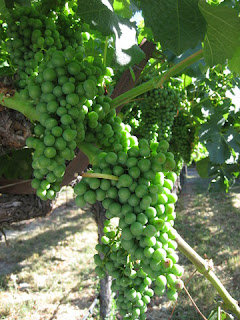
Green grapes on the vine, MacMurray Ranch, Healdsburg, California
At the same time, some of those training rides are enticing. Like the opportunity to bike some backroads in the wine country of Sonoma County. It's been years since I've biked up there.

The logistics always discourage me. I'm not up for driving more than two hours in the early morning to reach the starting point. Wine Country hotels are expensive, and fussy about demanding two-night minimum stays.

This year I explored Airbnb. Not only did I find a convenient location, I made some new friends in the process.

Best Buddies banner and my bike at the entrance to the MacMurray Ranch, Healdsburg, California
The ride started and finished on the private grounds of the MacMurray Ranch.

There was just one problem. I came down with (yet another) cold. [What is going on, this year?!] If I had been at home this morning, I would have stayed there—nursing my full-blown cold symptoms in bed.

Blooming allium with grapevines in the background, Mill Creek Vineyards, Healdsburg, California
Riding the longer 40-mile route was out of the question. If I'd had any doubts before I got to the ranch, they evaporated when I caught sight of my fellow riders. Can you say, “hammerfest?” [Yes, I thought you could.] I probably shouldn't be riding at all, but ... here I am. Twenty miles isn't much, really.

I got off to a rocky start. I'd brought my older road bike along, and although I'd carefully leveled the saddle when I reattached it after my recent Five Countries tour, I had not sufficiently tightened the bolts, nor had I given it a test ride. Before we rolled out of the driveway, it shifted and tilted when I hit the first bump. [It would be mile 15 before I finally got it properly clamped.] On the plus side, I'd replaced the speed sensor on that bike (also untested) and it was operating just fine.

Rows of grapevines with hills in the background, Westside Road, Healdsburg, California
With a hot day forecast, I was glad not to push myself hard. We headed straight for the Wohler Bridge, but time lost to the saddle shenanigans cost me the photo stop. I've crossed it many times on a bicycle, back in the days when it was part of the original Waves to Wine ride.

The short route, 21 miles with 540 feet of climbing, was a little taste of rolling Wine Country hills. Back at the ranch, we enjoyed lunch and a speech by a Best Buddies Ambassador. “Only 500 people (worldwide) have been diagnosed with the neurological disorder I have,” he explained. “How lucky am I!” Doctors told his parents he could never ride a bicycle; last year, he did the 30-mile route in the Hearst Castle Challenge. This year he's training for the 60-mile route.

How about you? 15, 30, 60, or 100 miles? You can sign up here.

July 11, 2017

Tour de Moffett Park

Tour de Moffett Park sign, Sunnyvale, CaliforniaYou've heard of the Tour de France, but what about the Tour de Moffett Park? [Uh huh, thought so.]

I made sure I biked to work today, having snagged an entry in the (non-competitive) Tour de Moffett Park.

This was the 14th (!) annual tour, which seems organized to lure people from the various companies in our neighborhood onto their bikes for a mid-day ride. Free lunch! Raffle prizes! What more do you need to know?

Riders queuing to sign in, Tour de Moffett Park, Sunnyvale, California
It was somewhat less than well-organized, with a mere three people set up to sign in some 400 (!) registered riders. As we stepped away with our route sheets, they encouraged people to ride together.

I had chosen the “long” route, of course (11 miles), and changed into my cycling gear for comfort. The rider behind me said “You look like you know what you're doing, I'm gonna follow you!” A second guy tagged along, and I took care to keep them in sight.

Much of the route was familiar from my weekend test ride, so it happened that I did (pretty much) know what I was doing.

I didn't win a prize, but I did score an extra lunch (many riders signed up, fewer actually showed up ... sigh). With ice cream and toppings for dessert, I definitely took in more calories than I burned.

I had plans for that extra lunch: Dinner in the park, on the way home!

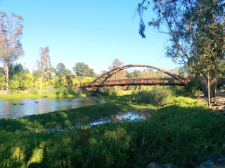
Bridge at Vasona Lake County Park, Los Gatos, California
I found a picnic table near the lake, and soon discovered the downside. The beggar squirrel I could fend off; the yellowjackets were intimidating. I dispatched two of them, and the rest buzzed off to find a friendlier food source.

For the day, some 48 miles and 1,020 feet of climbing. I threw in a gratuitous hillclimb on the way home ... which might have offset one or two spoons of ice cream (with chocolate sauce and rainbow sprinkles).

July 9, 2017

Test Ride

I have an idea for a (flat) ride, and I've been mulling over the route. Much of it will be on trails. Technically, five trails.

It's more fun to ride with a buddy, so I persuaded a friend to be my test rider. Knowing that a portion of the trail might get pretty rough (it did), I opted to ride my hybrid on this exploratory tour. (I'll  route to avoid that stretch in the future, which is exactly why I wanted to do a test ride.)

Levi's Stadium from the San Tomas Aquino Trail, Santa Clara, California
We'll pass Levi's Stadium.

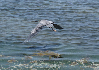
Great blue heron in flight over San Francisco Bay, Sunnyvale, California
We'll skirt along the marshland at the edge of San Francisco Bay.

Android Sculpture Garden, Google Visitor Center, Mountain View, California
We'll even pay a visit to the Garden of Tasty Treats.

The hybrid's too heavy to load into my car, so I rode to the start (and, back home)—57 miles in all, with 880 feet of climbing. Watch this space; actual ride coming ... soon.