July 30, 2017

For the Birds

Riders on the trail, Sunnyvale, California
The results are in: my route was a resounding success!

Twelve people joined me for the inaugural ride—including one rider on a folding (!) recumbent. “We'll all stay together,” I promised (wondering how I would keep track of such a large group).

They were a great bunch, though; when one rider flatted, another jumped in immediately to carry out the repair. “I like to do this,” he insisted. The rest of the group chatted away, and one rider pulled out a bag of grapes to share.

Seven Snowy Egrets, two American Avocets, and five unidentified birds, at the edge of San Francisco Bay, Sunnyvale, CaliforniaIn the ponds along the Bay Trail, we saw more egrets (and American Avocets) in one place than most people had ever seen. You'd think they were as common as sparrows.

Haze spoiled the view of the Diablo Range across San Francisco Bay, but the waters reflected a deep blue sky.

Snowy Egret with two chicks in a nest, Mountain View, CaliforniaIt's getting late in the season for the rookery, but we were not disappointed. Two fuzzy chicks were visible in their nest, with their attendant parent; they'd hatched a couple of weeks ago. Everyone was surprised to see these graceful birds nesting in the branches of sycamore trees; with their broad wingspans, it all seems so improbable. One rider remarked that he could stay there for hours, watching them.

Both Snowy and Great Egrets nest here; I explained how they were nearly hunted to extinction (for their fancy feathers—to adorn women's hats).

And then we got really lucky. As if the egrets weren't impressive enough, the Black-crowned Night-Herons were also on their nests. I knew there were two nests, and roughly where they were; but I wasn't confident they were still nesting.

My plan for lunch worked out well: enough choices to satisfy everyone, be it falafel, sushi, or curry.

We wrapped up where we began, near the small apricot orchard that Sunnyvale has preserved (and cultivates).

Apricot trees, Orchard Heritage Park, Sunnyvale, California
For me, a total of 53 miles with 1,080 feet of climbing. For everyone else, about 26 miles with 280 feet of climbing.

One enthusiastic rider exclaimed “I could do this ride every week!”

[Hmm, now there's an idea.] I have a couple of tweaks in mind ... stay tuned.

July 15, 2017

MacMurray Ranch

I have cycled 100 miles, eleven times, to raise funds for Best Buddies International over the past 10 years. And while the organizers offer a few training rides leading up to the Hearst Castle Challenge, I typically skip those—club rides and bike commutes keep me fit.

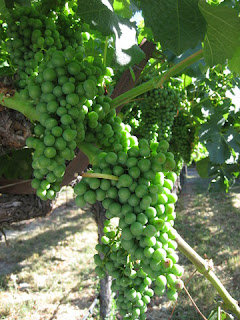
Green grapes on the vine, MacMurray Ranch, Healdsburg, California
At the same time, some of those training rides are enticing. Like the opportunity to bike some backroads in the wine country of Sonoma County. It's been years since I've biked up there.

The logistics always discourage me. I'm not up for driving more than two hours in the early morning to reach the starting point. Wine Country hotels are expensive, and fussy about demanding two-night minimum stays.

This year I explored Airbnb. Not only did I find a convenient location, I made some new friends in the process.

Best Buddies banner and my bike at the entrance to the MacMurray Ranch, Healdsburg, California
The ride started and finished on the private grounds of the MacMurray Ranch.

There was just one problem. I came down with (yet another) cold. [What is going on, this year?!] If I had been at home this morning, I would have stayed there—nursing my full-blown cold symptoms in bed.

Blooming allium with grapevines in the background, Mill Creek Vineyards, Healdsburg, California
Riding the longer 40-mile route was out of the question. If I'd had any doubts before I got to the ranch, they evaporated when I caught sight of my fellow riders. Can you say, “hammerfest?” [Yes, I thought you could.] I probably shouldn't be riding at all, but ... here I am. Twenty miles isn't much, really.

I got off to a rocky start. I'd brought my older road bike along, and although I'd carefully leveled the saddle when I reattached it after my recent Five Countries tour, I had not sufficiently tightened the bolts, nor had I given it a test ride. Before we rolled out of the driveway, it shifted and tilted when I hit the first bump. [It would be mile 15 before I finally got it properly clamped.] On the plus side, I'd replaced the speed sensor on that bike (also untested) and it was operating just fine.

Rows of grapevines with hills in the background, Westside Road, Healdsburg, California
With a hot day forecast, I was glad not to push myself hard. We headed straight for the Wohler Bridge, but time lost to the saddle shenanigans cost me the photo stop. I've crossed it many times on a bicycle, back in the days when it was part of the original Waves to Wine ride.

The short route, 21 miles with 540 feet of climbing, was a little taste of rolling Wine Country hills. Back at the ranch, we enjoyed lunch and a speech by a Best Buddies Ambassador. “Only 500 people (worldwide) have been diagnosed with the neurological disorder I have,” he explained. “How lucky am I!” Doctors told his parents he could never ride a bicycle; last year, he did the 30-mile route in the Hearst Castle Challenge. This year he's training for the 60-mile route.

How about you? 15, 30, 60, or 100 miles? You can sign up here.

July 11, 2017

Tour de Moffett Park

Tour de Moffett Park sign, Sunnyvale, CaliforniaYou've heard of the Tour de France, but what about the Tour de Moffett Park? [Uh huh, thought so.]

I made sure I biked to work today, having snagged an entry in the (non-competitive) Tour de Moffett Park.

This was the 14th (!) annual tour, which seems organized to lure people from the various companies in our neighborhood onto their bikes for a mid-day ride. Free lunch! Raffle prizes! What more do you need to know?

Riders queuing to sign in, Tour de Moffett Park, Sunnyvale, California
It was somewhat less than well-organized, with a mere three people set up to sign in some 400 (!) registered riders. As we stepped away with our route sheets, they encouraged people to ride together.

I had chosen the “long” route, of course (11 miles), and changed into my cycling gear for comfort. The rider behind me said “You look like you know what you're doing, I'm gonna follow you!” A second guy tagged along, and I took care to keep them in sight.

Much of the route was familiar from my weekend test ride, so it happened that I did (pretty much) know what I was doing.

I didn't win a prize, but I did score an extra lunch (many riders signed up, fewer actually showed up ... sigh). With ice cream and toppings for dessert, I definitely took in more calories than I burned.

I had plans for that extra lunch: Dinner in the park, on the way home!

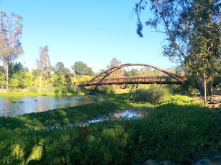
Bridge at Vasona Lake County Park, Los Gatos, California
I found a picnic table near the lake, and soon discovered the downside. The beggar squirrel I could fend off; the yellowjackets were intimidating. I dispatched two of them, and the rest buzzed off to find a friendlier food source.

For the day, some 48 miles and 1,020 feet of climbing. I threw in a gratuitous hillclimb on the way home ... which might have offset one or two spoons of ice cream (with chocolate sauce and rainbow sprinkles).

July 9, 2017

Test Ride

I have an idea for a (flat) ride, and I've been mulling over the route. Much of it will be on trails. Technically, five trails.

It's more fun to ride with a buddy, so I persuaded a friend to be my test rider. Knowing that a portion of the trail might get pretty rough (it did), I opted to ride my hybrid on this exploratory tour. (I'll  route to avoid that stretch in the future, which is exactly why I wanted to do a test ride.)

Levi's Stadium from the San Tomas Aquino Trail, Santa Clara, California
We'll pass Levi's Stadium.

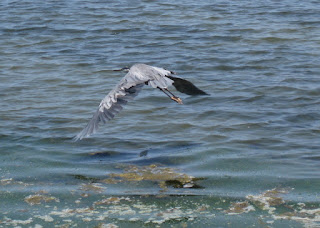
Great blue heron in flight over San Francisco Bay, Sunnyvale, California
We'll skirt along the marshland at the edge of San Francisco Bay.

Android Sculpture Garden, Google Visitor Center, Mountain View, California
We'll even pay a visit to the Garden of Tasty Treats.

The hybrid's too heavy to load into my car, so I rode to the start (and, back home)—57 miles in all, with 880 feet of climbing. Watch this space; actual ride coming ... soon.

July 8, 2017

Some Like It Hot

We knew the day would warm up; the forecast included warnings about “fire weather:” low humidity, hot air, and gusty winds that would quickly cause any fire to burn hot and fast. When a heat advisory was added to the mix, we missed that news.

Charred fields at Joseph D. Grant County Park, San Jose, California
We were surprised to see the golden fields of Joseph D. Grant County Park charred. We'd also missed that news, of a fire that burned here a couple of weeks ago. The roadway, and some of the brush, was stained pink with the residue of the fire retardant that would have been sprayed by a low-flying tanker.

Charred tree and roadway stained pink with fire retardant, Mt. Hamilton Road, San Jose, California
Some majestic trees have been lost, but the ranch's historic homestead was unscathed. Close call.

We regretted not getting an earlier start; I envied cyclists who were already descending. By the time we reached the park, about halfway to the top, the heat was taking its toll on me. I found myself stopping more and more often, and it was taking longer than usual for my heart rate to recover.

I thought about aborting the climb. (That would have been the sensible choice.) I kept going. I was mystified by cyclists outfitted head to toe in heat-absorbing black gear; I'd planned to wear my Death Ride jersey in solidarity with those doing the 2017 edition today, but nixed that in favor of pure white.

The gusty winds from the northwest materialized, but offered little relief—the air was just too hot. Was the breeze evaporating the sweat from my arms that fast, or was my dry skin a warning of heat exhaustion?

Lick Observatory atop Mt. Hamilton, San Jose, California
When the observatory comes into clear view, you still have a ways to go. And I was, uncharacteristically, nearly out of water. Like virtually all the cyclists we saw that day, I repeatedly aimed for a (rare) patch of shade and stopped to rest.

This was a ride of many firsts. The first time I've seen so few cyclists on the mountain. My slowest ascent, to date (and hopefully, ever). The first time I drained both bottles of water on this climb. The first time I saw streaks of dried salt on my bike shorts. The first time I bought and consumed two full cans of Gatorade at the summit. (Thank you, Lick Observatory, for stocking that.)

The temperature in San Jose today topped out above 100F. I was so glad not to be one of the riders in Markleeville. Thirty-nine miles with 4,670 feet of climbing were more than enough for me.

July 4, 2017

Independence Day

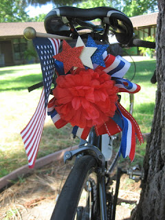
Bicycle saddle decorated with an American Flag and red, white, and blue ribbon, San Jose, California
The morning began celebrating our national holiday with like-minded folks (cyclists, of course) at our club's traditional pancake breakfast. Having learned the hard way last year, I set out earlier to be sure the tables and chairs hadn't already been taken down when I arrived. I'm happy to do my part with that chore, but not when the tear-down starts a full hour before the post-breakfast rides begin.

It wasn't much different this year, with chairs being folded and stacked while people stood patiently in line at the griddle.

My ride buddy and I parted ways at Montebello, which she was determined to climb; I was more keen on the shade of Stevens Canyon and a shorter outing: 38 miles with a manageable 1,765 feet of climbing.

Our route passes the Sunnyvale Rod and Gun Club's property, where members were evidently celebrating their right to bear arms (with like-minded folks). The sound was a prelude to the illegal fireworks that will erupt later tonight.

There were lots of families picnicking in the parks, kids splashing in the creek.

All the bridges on the upper portion of Stevens Canyon Road have been replaced. Not only are the old wooden crossings gone, the new editions seem more deluxe than needed for this secluded dead-end road. The homeowners have some clout, perhaps.

Stone arch with an iron gate and a wooden sign that says "Go Away," Stevens Canyon Road, Cupertino, California
They certainly put out the unwelcome mat: There is no shortage of “No Trespassing” and “Private Road” signs along the way. Or one, simply stated: “Go Away.”

Rather a sharp contrast to the impromptu hospitality of the homeowner in Scotland, a few weeks ago, who invited our entire group into his home to use the bathroom.

Happy Independence Day.

July 1, 2017

And Again

Calaveras was so lovely last week, we decided to pay a return visit. Looks like repairs will be starting this week on the lower section that's closed, so it was definitely the right call to ride it today.

View of Calaveras Reservoir from Felter Road, San Jose, California
This week we added a prelude, the challenging climb up Felter—all the way to the vista point on Sierra Road. At least one of our riders had not been there before. A few hardy souls chose to climb Calaveras before Felter; I prefer to tackle the tougher climb first. (I have climbed Felter last, albeit after the full return climb from Sunol, and it hurt. A lot.)

Herd of shorn alpacas at a ranch along Felter Road, San Jose, California
In addition to the usual turkey vultures and a red-tailed hawk, I spotted a Western Bluebird, and an interesting bird I couldn't identify. Plus a small herd of alpacas.

North end of Calaveras Reservoir near the dam, Alameda County, California
Near the dam, we chatted with a worker exiting the gate. We asked about the closure, about the slide damage blocking the route to Sunol. He said the repairs were done, but the road was closed at the dam by “Homeland Security.” “Drinking water,” he explained. But there has been a reservoir here for more than 100 years,  and the road has passed through this valley for a long time indeed. I expect the closure has more to do with the construction site than with the water below. The project's web site continues to peg the closure on winter storm damage.

As we headed back along the reservoir, a minivan passed us (heading up). What's not to understand about “Road Closed” signs? Not to mention an actual barricade.

Eventually they discovered that they had to return whence they came, passing us again. Frankly, driving a minivan on the curvy ups and downs of Calaveras Road would not be my idea of a fun time.

Wind-drive mobile figure of boy with soccer ball, Cardoza Park, Milpitas, California
Back at the park where we started, a whimsical piece of art caught my eye. Was it new, or was it the effect of the breeze setting it in motion?

A more challenging outing this week: 34 miles with 3,345 feet of climbing. Despite having to share the upper road with two vehicles, it was so worth the trip.