September 10, 2014

Paradise

I have seen more Caltrans trucks in two days in the Eastern Sierras than I've seen all year in the Bay Area. Everywhere, roadwork.

Yellow rabbitbrush in bloom, aspen and evergreen trees, rugged granite peaks along Upper Rock Creek Road in the Eastern Sierras.
We learned that the upper portion of Rock Creek Road had been pulverized in preparation for re-paving, which disappointed some and delighted others. I fell into the first group, having never climbed it. The second group included many who had.

In his Complete Guide to Climbing (By Bike) books, John Summerson listed Rock Creek as the 10th most difficult climb in California, and 26th in the United States. The climb tops out at an elevation of 10,220 feet, the end of the highest paved road in California. I would not find out today whether I could turn the pedals at that altitude, and the road work may not be completed by this time next year, either.

Sign: Smokey Says Be Fire Safe in Paradise. Prevent Wildfires.
Lower Rock Creek Road passes through Paradise, which (as one might expect) is not a crowded place. Population: 120. Reaching Upper Rock Creek Road entails a short trip on U.S. Route 395. Three of us (the stragglers) reached the highway ... and paused. That stretch of road was being re-paved; all vehicles were being funneled into the rightmost lane, which was barely wide enough for the tractor-trailers lumbering through and which had no shoulder whatsoever. [Yikes.]

Luckily, a worker was nearby and directed us to ride in the closure: smack down the middle of the highway! Queens (and King) of the Road, we were.

Bicycling up the center of U.S. Route 395 toward Tom's Place Resort.
There was some uncertainty about how far we could venture on Upper Rock Creek. The pavement might end six miles up the road, or at 1.6 miles. Heavy equipment was tearing into the right lane of a bridge over the creek. A flagman waved us through, and a descending rider told us we could go up four miles before the pavement ended. [Yay!] Later we would be the envy of the rest of our group: everyone else had turned back at this bridge, discouraged by the flagman and a long line of cars.

End of pavement four miles from the end of Upper Rock Creek Road in the Eastern Sierras.
Shortchanged by Upper Rock Creek, we headed northwest for a consolation climb along McGee Creek. Returning riders cautioned that it was steep: 12-14% grade. “You'll need your low gears,” they advised. Not to worry; my lowest gears get a lot of action.

Bare brown peaks, blooming yellow rabbitbrush, and evergreen trees along the creek near the end of McGee Creek Road (paved).
We felt intimidated, but we did not turn back. The grade felt more like 9%, and my stats later confirmed my hunch: 8.8%. My heart rate spiked at one point, so there definitely was a steeper segment (for a distance of about 20 yards). We were rewarded with views of Crowley Lake and celebrated with treats at the local bakery; then we realized that we faced more climbing in retracing the morning's route. Remember that long, sweeping descent on Lower Rock Creek? [Uh-oh.]

View of Crowley Lake and distant mountains from McGee Creek Road in the Eastern Sierras.
We were astonished to enjoy the wide shoulder of U.S. 395 on our return—road markings were fully painted, and the workers were collecting the safety cones and temporary markers. All in the same day! In the Bay Area, temporary markers can be in place for weeks before the lanes are striped.

Being the few who completed the full route, and being slow, we were the last to roll back to the start. And proud, we were: 51 miles, 6,005 feet of climbing.

September 9, 2014

Pine Creek

Wow. Wow, wow, wow.

pep with bicycle alone Pine Creek, mountains in the distance, near Bishop, California
I had not spent time in the Eastern Sierras before this trip. Some club members have been leading rides here each fall for the past few years, and this was the year I managed to join the group. The hotel clerk had commented “You folks like to suffer!” when the leader shared our plans.

Two cyclists in the upper reaches of Pine Creek Road, near Bishop, California
Pine Creek Road was our first climb in the Bishop area. In the first editions of his Complete Guide to Climbing (By Bike) books, John Summerson listed Pine Creek as the 49th most difficult climb in California, and 81st in the United States. (In the second edition of the national guide, it has fallen off the top 100 list.) I tackled it with some trepidation, but did not find it difficult (despite the altitude, and the heat). The scenery was even more stunning than I had hoped. The slower I climbed, the more I could take in.

Pine Creek near Bishop California
We marveled at the robust flow of Pine Creek (given our extended drought), and wondered about the source. In a rocky, brown landscape studded with sagebrush, it was easy to trace the water's path: just follow the green line (trees, bushes, grasses). At higher elevations, I even saw some ferns!

View from the end of Pine Creek Road, near Bishop, California
The public road ended at a gate to a (closed) tungsten mine; our highest point, about 7,250 feet. Starting my descent, a cautionary sign caught my eye: Trucks Use Low Gears. Translation: Cyclists Use High Gears. My highest was maxed out; I surrendered to gravity and coasted. The pavement was smooth and clear, with long straight stretches—a glorious descent!

Bishop tuff alongside the Owens Canal near Bishop, California
Back on the valley floor, we followed the route across the highway into a small gorge, passing through some gates to follow an access road alongside the Owens River and Pleasant Valley Reservoir. We marveled at the exposed pink walls of the gorge—Bishop tuff, pumice formed by a massive volcanic eruption some 760,000 years ago.

Bicycle against a wall of Bishop tuff along the Owens Canal, near Bishop, California
For the day, 48 miles with some 3,770 feet of climbing, and no suffering at all. Really.

September 8, 2014

Bishop or Bust

For the past few years, some club members have been leading a set of fall rides in the Eastern Sierras. This year, I resolved to join them; my calendar was clear.

Mono Lake, California
It's a long way to Bishop (314 miles). Road trip! But could I handle the drive? Plan A was to split the journey, driving about halfway on Sunday afternoon and finishing on Monday morning.

Paradoxically, it can be easier for me to bike 100 miles than to drive it. Freeway driving, especially in a warm sunny car, lulls me to sleep.

To execute Plan A, I needed to return from Best Buddies, load up the car, and go. In other words, I needed to have my act together ... which I did not.

The prospect of arriving at some motel in an unfamiliar town at night was not appealing, so I resorted to Plan B: Get a good night's rest and drive the distance in one day.

I avoided the route through Yosemite, with its sightseers and delays for road work, opting instead for the longer northerly route over the Sonora Pass. I drove for miles and miles (and miles) without seeing another human being, much less a vehicle, and was glad that my mechanic had inspected the car last week.

I made it! [Whew.] I didn't feel drowsy, and I think the scenic route helped with that. Eighty miles of winding roads through a national forest commanded my attention, and I didn't even get halfway through my collection of MP3 tunes. The views got more spectacular as I approached the summit; unsure how well I would manage the drive, I didn't stop as the photo opportunities rolled past my windows. [Note to self: Take the same route home. Stop often.]

By the time I reached Mono Lake, another destination long on my wish list, I was confident that I could complete the drive safely. I made a quick stop, and planned a longer visit for the return drive. Closer to Bishop, the afternoon sun delivered a rainbow in the hills behind Crowley Lake.

Rainbow over Crowley Lake, Bishop, California
Little did I know that I would get a better perspective on that reservoir in a few days' time.

September 6, 2014

Love is All Around

pep with Best Buddies Ambassador Donna Gunn and Willard
One hour into the ride, I had the opportunity to chat with a Best Buddies Ambassador, Donna Gunn, and her “pet rat” Willard. [Quite the sense of humor, eh?] During the brief opening program before the Hearst Castle Challenge century riders started rolling, she had spoken about how Best Buddies had brought “the spirit of belonging” into her life. Donna was our host at the first rest stop, and she was bobbing with excitement to meet the cyclists in all our colorful gear.

I thought last year's pace was blistering ... ha! With George Hincapie, local race champions, and a smattering of Olympians at the front, I could barely hang on. Over the first 30 minutes, I averaged 20 mph. That included the first small hill, where I lost contact with the front of the pack. They were out of sight by the time I made the turn toward Highway 1. The next group flowed past me up a rolling hill, and I heard one of the retired pros call out “C'mon, Anthony, everybody is fast going downhill.” [Anthony Shriver was riding the full century this year for the first time.] They crested the hill and relaxed ever so slightly. I attacked. It was a proud moment when I passed the lot of them, and the retired pro called out “Nice work!”

Sunlit cove against a gray sky along the Pacific Coast Highway
Mother Nature presented us with the traditional morning gloom, but the sun found a way to break through to highlight this cove before fully beating back the marine layer. I was determined not to have the specter of the broom wagon dogging me this year, which meant riding faster and being less of a tourist along the way, but how could I not stop to capture this magical moment? A passing rider shouted “Great shot!” and then called out his email address so I could send him a copy. [Right. Like I would remember that.]

Turquoise cove with kelp along the rocky California Pacific coastline.
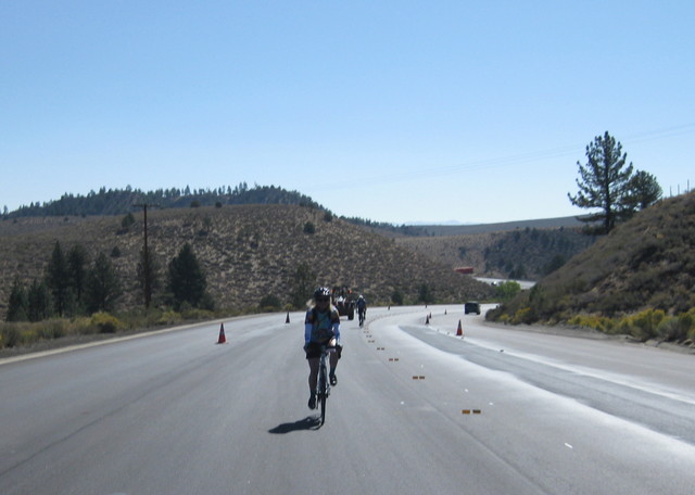
Of course, I can't sustain a 20 mph pace to finish a century in five hours. Over the first hour, I averaged 17.8 mph—which for me is pretty darned amazing, hills or no hills.

The post-lunch climbs were lonely; the fast guys were long gone, and there was not a single slow rider walking up. (These days, they load them onto vans at the rest stop and ferry them to the top.) The second climb is slightly steeper, but the first climb breaks your spirit. The contours obscure the road ahead; you round a bend only to see the next highest point. I hammered the last 13 miles and stopped counting the cyclists I overtook. Some, I passed more than once (after pausing for the occasional photo). I rolled across the finish line in 7:05 (moving time), averaging 14 mph. I could have passed the handful of riders ahead of me in the final stretch, but that would have been rude.

I thought the “race” announcer missed me in the scrum, but he had a sharp eye. As one of the top 25 fundraisers, my bib was yellow and my number was my rank: 13. The pros have a tradition for that number, and I followed it: I wore my number upside down. “Just like Fabian Cancellara,” the announcer proclaimed. “I learned that from Fabian,” I smiled.

Neptune Pool at Hearst Castle, drained due to the historic California drought.
After celebrating at the post-ride barbecue and concert (Bruce Hornsby, this year), I finished the night as an invited guest at the intimate party up on the hill. The first time I swam in the Neptune Pool, I expected that it was a once-in-a-lifetime experience. The next five times, I lingered as if there would never be another chance. Given the now-historic California drought, this year the pool stands empty. A good opportunity for some repairs, they say.

Next year?

August 30, 2014

Gimme a Lift

There are two sports in which I enjoy going down hills. One involves a lift that brings me to the top of the mountain. As I made my way to the summit of Morgan Territory Road, I dreamed of a rope tow.

We were looping counter-clockwise around Mount Diablo today, which entails a steeper ascent up the front side of Morgan Territory Road. In the full sun, it felt like my shorts were ablaze. It was just a little past 10:00 a.m. and the day would only get hotter. Our small group splintered early. I joined the faction that planned to climb the lower portion of Mount Diablo. That would be challenging enough.

Never a fan of cycling on Ygnacio Valley Road, I had mapped out a shortcut in advance. Heading into the center of downtown Clayton, I stumbled upon the town's Labor Day party, featuring a display of shiny classic cars. This Ford Fairlane Crown Victoria brought a smile to my face, staged with a drive-in intercom next to the driver's window and a burger-and-fries tray perched on the passenger's window. (The car dates back to the year I was born, and it's in much better shape.)

It turned out that the path in my plan headed sharply uphill. No problem, I thought, I have gears. It turned out to be steep enough that a few steps had been placed along the way. [Surprise!] A short hike brought me to the back fence of an elementary school, and the gate was open. Playgrounds have drinking fountains ... I gratefully topped off my water bottles.

The rest of the shortcut was a big win, following a wide suburban street and the deserted campus roads of Cal State East Bay in Concord to cut off most of the unpleasant climb on busy Ygnacio Valley Road. The shoulder may be wide, but the traffic moves faster than the posted limit—including the tractor-trailers. It is decidedly not fun.

Our counter-clockwise approach afforded some splendid views: first, moving slowly up the wide-open side of Morgan Territory Road and later coming around the back side of Mount Diablo. It also meant that our climbs were exposed to the baking sun, while our descents were shaded. [Note to self: embrace the clockwise route.]

The dry hills shimmered in the sun. Look at North Gate Road—doesn't that just beg to be climbed? Mercifully, there was a bit of a breeze. The higher I climbed, the stronger it became. Don't get me wrong: on a hot day, this climb is no picnic. The local high temperature yesterday was 93F. I made a deal with myself to pause once per mile in the nearest patch of shade to hydrate and get my heart rate down. The road is never steep, but in the heat the best recovery I could manage was 137 bpm.

There is a school near the end of Mount Diablo Scenic Boulevard. Evidently, there is also a soccer camp. And so it came to pass that a soccer ball flew across the road, from my left. A fluke, or a deliberate act? I heard only the laughter of boys—no warning, no cry of alarm, no apology. Had it hit my front wheel, I would have crashed. Had it hit my head, I would have crashed. It struck my upper arm with enough force that it hurt, then ricocheted high overhead and to the right. I continued on my way without so much as a glance in their direction. I just wanted to get out of there.

For the day, nearly 56 miles with 4,615 feet of climbing. Mandatory stop on drive home: one ice-cold smoothie. Peaches, mangoes, and strawberries—oh my!

August 23, 2014

Steady as She Goes

View of coastal fog bank from Bear Gulch Road West
Years ago, a friend of mine met her (then future) husband while climbing Old La Honda Road. Being the benchmark climb of the Bay Area, it's enormously popular. I was bracketed by two club members today when a familiar voice rang out: a colleague was sprinting up the hill. After he reached the top, he came back down to ride alongside me and chat. “Don't fall over,” I joked. For me, this was the most convenient way to reach a particular section of Skyline; I was not riding for a personal best, just hard enough to carry on a somewhat breathless conversation.

It looked like a party at the top—I've never seen so many cyclists there. Surely they didn't all pass me? I had admired one guy, in particular, who flew past me with grace and no apparent effort. My best time on this hill was a few seconds on the far side of 30 minutes, and thus it will ever be.

I wasn't planning to line up all the climbs west of Skyline between Highway 84 and Kings Mountain on successive cycling weekends, but that is how it turned out. I would tackle the most challenging climb today: Bear Gulch West. After dropping gently through the redwoods, the road pitches down more sharply through rolling, open fields. A fog bank lingered over the Pacific, but the sea was visible at one point.

The key thing to remember about this climb is to shift into your lowest gear before you roll to a stop at the end of the road. My memory served me well: when I saw the sign warning about the blind curve ahead, I shifted down, down, down. Moments later I had plunged from wide open space into the small redwood grove that shades the gate at the end of the road. Even in my lowest gear, I waited until my fellow riders had cleared the road before I started to turn the cranks. I think I can, I think I can ...

Having climbed triumphantly back to Skyline without a pause, my reward was a fabulous car-free descent of Kings Mountain. I passed another cyclist near the top, and he seemed dispirited that he couldn't catch me. Whenever he was within range, his noisy freehub made it seem like I was being chased down the hill by an angry bumblebee. Near the bottom, he blew through a stop sign and (thus) passed me. A bit farther down the road, he managed to drop his chain and (thus) I passed him. Karma?

I completed some 25 miles with 3,385 feet of climbing in less than 3 hours—averaging 0.4 mph faster than a comparable outing three weeks ago. Pleased with my pace, I am.

August 19, 2014

The Finder of Lost Things

NJ Transit rail car interior
All aboard for a trip back in time with New Jersey Transit, to the era of train travel in which a conductor rapidly punched an inscrutable pattern of holes in a little slip of paper and tucked it under a clip on the seatback in front of you. Not as creatively as the conductor on the Polar Express, but nearly as quaint.

On the last afternoon of a brief family visit, I stopped at the local supermarket. Being more sports-car-than-minivan-experienced, I am uneasy driving the family Odyssey around. I found a distant, comfortably uncrowded section of the lot and parked without incident. On the way out of the store, something caught my eye: a small leather card sleeve on the pavement.

Last spring, I was biking to work when I spotted an iPhone face down on the street. I passed it before circling back. If that were my iPhone, I would want someone like me to find it, I reasoned. I picked it up; if I couldn't figure out who the owner was, I expected that an Apple Store could sort it out. At the office, I pulled out the phone. “Swipe to unlock.” [Really, people?] I passed the phone to a colleague with more iPhone savvy; the phone book was nearly empty, but within moments he found the owner's corporate email account. [She didn't even know that she'd dropped the phone.] Her husband presented me with a basket of kiwi fruit when he retrieved the phone later that evening.

I picked up the card sleeve. It was stuffed with credit cards and a transit pass, with an out-of-state driver's license on top. I thought about returning to the store and handing it in to customer service; but the owner might be long gone, having no idea where he managed to drop it.

Years ago, I found a credit card on the sidewalk in my town. It was issued by a Canadian bank, and all I could imagine was a much-inconvenienced (and panicked) tourist. I called the toll-free number printed on the back of the card and tried (in vain) to convince the bank to contact their customer so I could happily return the card. They would do nothing but cancel it. Now when I find a card, I don't bother calling; I just shred it.

This leather sleeve was different—with a driver's license, I had an address. Maybe I could get in touch with the nice-looking guy who lost it and return it. What an enormous pain it would be to replace his license and all those credit cards. If this were my wallet, I would want someone like me to find it.

Back at my laptop, I set to work. In the worst case, I would carry it back to the Bay Area in the morning and mail it. [At this point, anyone else would turn to Facebook. But I am not a Facebook-y type, so I turned to Google.] The name looked uncommon, but wasn't. Within a few minutes, I discovered that this handsome fella was not just anyone; he was a lacrosse player, with his own Wikipedia entry. There was his date of birth for all to see; it matched the one on his driver's license. I foraged for email addresses on websites where someone would plausibly know him. The first message paid off within 30 minutes; he was much relieved and came by to retrieve the goods.

He shared the story: He and his wife had just bought a house in a neighboring town. With his toddler in tow, he had wheeled a cart full of groceries to the cash register ... and couldn't pay. We shared a laugh.

“There are good, honest people in the world!” he thanked me. Could he give me something? I waved him off.

“Pay it forward.”