December 27, 2014

Piled High and Deep

West end of the Bay Head Yacht Club building, Bay Head, New Jersey
Back in the old neighborhood for the holidays, I had a chance to check out the status of the post-Sandy work on a local institution, the Bay Head Yacht Club.

Underside view of the pilings supporting the Bay Head Yacht Club building, Bay Head, New Jersey
Last year, the main building had been lifted and shifted away from its foundation; pilings were slowly being pummeled down to bedrock, some 60 feet below the shallow waters of Barnegat Bay. One year later, it's open (for members) and grander than ever.

Full length view of the Bay Head Yacht Club building from the south, Bay Head, New Jersey.
Seizing the opportunity to expand, the core of the original building was preserved and extended at both ends. An elevator supplements the staircases to ferry people between the dock level and the first floor.

The bay side has more window panes than I would want to count, which must ensure a spectacular view on days better suited to the cozy warmth of the hearth than the breezy porches.

Pair of swans in the late afternoon sunlight, Barnegat Bay, Bay Head, New Jersey
Too bad I missed the open house, which preceded my visit. Poor planning on their part, don't you think?

December 18, 2014

Birds on the Wire

Pair of crows perched on a wire, grooming.
Crows are a common sight, but this pair put on an uncommon show this morning.

The crow on the right must be afflicted with something. (Mites, most likely.) The crow on the left was grooming the infested one, picking away at the back of the other bird's head.

When the helper bird turned and inched away, the itchy bird followed. Edging close, the crow bowed its head to ask for more. The helper was indulgent, for a little while longer, before winging to a higher perch.

The afflicted bird cawed noisily, in protest, before scratching and pecking under an extended wing.

We all try, in our way, to be free. But sometimes, we need a little help from our friends.

November 28, 2014

Eleven at Eleven

Do I know my fellow cyclists, or what?

Dry bed of the Guadaupe Reservoir, San Jose, California
The day after Thanksgiving is not for shopping; it's for burning off some of yesterday's calories. (Turkey, stuffing, gravy, mashed potatoes, veggies, pie.)


Six riders joined me for a little trip up Mt. Umunhum. We took the direct approach on Hicks Road from the west. The painful approach.

Surprisingly, it was a vest-and-arm-warmers kind of day; we're having a late (very late) November spell of warm weather. I expected little traffic on the back roads, but I was surprised to see no wildlife—especially after seeing so many deer just two weeks ago. Maybe they had the day off, too?

We reached mile 11 at 11:00 a.m., having already climbed some 1500 feet. I was especially proud at how well I'd climbed Hicks after two guys reported that they'd needed to stop on the way up. I remember trips up Hicks that required multiple stops. I remember weaving up the hill like a paperboy. I remember the first time I climbed it, when I asked a passing rider how much farther it was to the top and told him it was okay to lie to me. None of that, today; I pedaled right on up, keeping my heart rate in check. (Peaked at 178 bpm.)

Climbing Mt. Umunhum ... well, that's another story. I remembered not to be tricked by the first steep bit. There, anticipating more of the same around a sharp bend, I have often paused (prematurely). Just stay with it, the grade relents on the other side.

The next steep bit is longer—almost half a mile. I wimped out, pausing to get my heart rate back into a more comfortable zone. A passing rider encouraged me: “Good job!” he called out.

A couple of riders had been chided by a ranger for riding up to the White Line of Death. [Pshaw!] Really, there is nothing wrong with going that far—even more so now that we know that the true boundary is above it. I had expected to stop at the new boundary line today, but decided not to risk a contentious exchange with The Authorities.

View from the White Line of Death, Mt. Umunhum Road, Santa Clara County, California
I paid my respects at the line before dropping the short distance to the downhill side of the lower pair of “No trespassing” signs—shortly before said ranger reappeared. She couldn't fault us, but still felt compelled to warn us about respecting private property, the “rough” nature of the locals, etc., etc. She continued down the hill and stopped again, out of sight, evidently waiting to confirm that we were heading down (not up). She continued to hover, shadowing us to the gate and watching us leave.

We're not the vandals who spray graffiti on the pavement. We're not the criminals who cultivate weed in the hills. Hooligans in spandex, we are; riding our bikes up the crumbling pavement because ... we can.

Used about 1400 Calories climbing some 3,695 feet over thirty miles. There's another piece of apple pie with my name on it.

November 23, 2014

Urban Wilderness

Looking at this dreamscape, you wouldn't guess the view at your back: San Jose, the bay, all the way to San Francisco (and beyond). Following a rainy day, I expected the skies to be crystal clear—not magically misty.

Sierra Road ramps steeply at the start. Whose idea was this? [Oh, wait ... it was my idea.] It would be difficult enough without the visual intimidation factor.

We seemed to be the only cyclists climbing Sierra today; that's a first. Birds were chirping, cattle were lowing, sirens were wailing. Sirens? Evidently some emergency was unfolding in the urbanized world below us. I began to wonder if they were heading up the hill after us, they blared for such a long time.

Until you pass the summit, you don't really leave civilization behind. Roadside litter is ever present, and the scourge of graffiti is a vivid reminder: the vandals' marks have been blacked out on the pavement, so they tag the fenceposts. It was most disheartening to see the huge tree they scarred with paint.

Trails are marked at the top, now that there is a parking lot for the Sierra Vista Open Space Preserve. I snagged a brochure for a future hike. With names like “Upper Calaveras Fault Trail” and “Lower Calaveras Fault Trail,” it is easy to understand why the land is so rugged.

More than 2,100 feet of climbing over 17 miles: a tidy sum.

November 20, 2014

Stayin' Alive, Take Two

Wet Strida illuminated by my headlight (400 lumens).
The first thing I noted about riding my trusty little Strida in the rain was that the fenders were less than effective. The rear fender's mud flap was lost some time ago, but tonight I was getting sprayed from the front. [Upon later inspection, it appears that the pliable plastic fender is somewhat warped to one side.]

I regretted not biking to work yesterday, when the threatened rain never quite made it over the coastal hills. Given that the roads were wet this morning, I opted to ride the commuter shuttle instead of making a mess of the commute bike. With a 50% chance of evening rain, I took a chance and chose the Strida over striding to the bus stop.

I lost the bet. [Ah, well. Once you're wet, you're wet.] It's only 1.6 miles.

I could shave the trip to 1.2 miles, but that requires biking on a busy local thoroughfare: mostly two lanes in each direction, separated by a median. The problem with that route are all the distractions. My bike is well-lit, but I'm a small fish swimming in a sea of bright lights: signs for businesses, traffic signals, pedestrian signals, street lights, vehicle lights.

The longer route is safer: it passes mostly through residential neighborhoods. In the darkness, I stand out: reflectors on wheels, pedals, and rear rack, reflective sidewalls on my tires, a reflective stripe down the front of the bike, reflective stripes on my messenger bag. Of course, none of that counts until some light source bounces back. So, I have a blinking white light on my handlebar. Two more blazing lights will encourage you to avert your gaze: a blinking red taillight (35 lumens) mounted on the rear rack, and a powerful headlight mounted on my helmet. Motorists give me a lot of space, at night. If they see me.

I watched the car heading through the church's parking lot, toward the exit. In self-defense, I slowed my pace and focused. I was the only moving thing on the street. In the bike lane.

She's not looking.

She's not looking.

She's not going to stop.

This is how cyclists die.

The driver pulled out directly across my path, making a left turn while staring exclusively to her right. She didn't even glance to her left until she was into the street, shocked [I can only imagine] by 400 lumens in her face. At close range.

Disc brakes, in the rain, for the win. They stopped the bike.

After I took a deep breath and resumed pedaling, I heard:
I'm so sorry. I'm so sorry.
She had stopped her car down the street and lowered the window to call out an apology.

I'm sorry, too. I'm sorry that the State of California saw fit to award you a driver's license.

November 16, 2014

Girlfriends

Some people prefer to bike with their club. Some people prefer to bike with their friends. [Do both, I say!]

Four does grazing at the edge of woodland.The ride calendar offered many choices. Long rides. Fast rides. I needed a just-right ride.

I knew that one of my regular ride buddies would join me; beyond that, you never know who will show up.

Surprise! We had an unexpected five-girl outing.

“Don't wait for us, we may not go all the way to the top,” two of them cautioned. [They insist that I'm a fast rider.]

A Sunday morning ride can be especially quiet. We spotted a flock of turkeys in a field, then encountered a fine buck standing his ground in the middle of the road. He proved camera-shy when we stopped to admire him. The local does were more skittish.

Ten does, five women, 18 miles, and 1,900 feet of climbing. Everyone made it to the top, with cheers and congratulations.

November 12, 2014

101

Not the freeway (U.S. Highway 101).

Not an academic course number (though “Commuting 101” would fit).

Cyclist emerging from the fog at the far end of a bike/pedestrian bridge.
Number of trips to the office by bicycle this year, as of today: 101.

Most trips involved returning home by bicycle, but since we reverted to Standard Time I rely on a commuter shuttle for most of the evening trip. [Less than two miles in the dark, versus twenty.]

Most trips are routine, but there have been some memorable moments in those 3,500 miles.

In the past few weeks, I surprised a covey of California quail crossing a road: one ran, the others actually took flight!

I have ridden from sunshine into ground fog so thick I couldn't see either end of a bridge from its center.

Coots nibbling on breakfast alongside the trail.
When I take the scenic morning route through the park, I can expect to thread my way through a flock of coots.

I had a close call with an idiot on a heavy electric bike who rounded a corner at speed into the bike lane. He didn't even glance to his left, much less heed the stop sign. [At the next traffic light, I gave him a piece of my mind.]

My Squirrel Scare Tactic elicited a “Nice trick!” compliment from a nearby cyclist. “Tsssss!” I hiss, loudly. This reliably sends the pesky rodent running, at warp speed, in the opposite direction. [Try it!]

For those increasingly common electrified pests ... an AirZound, perhaps?

November 8, 2014

WLOD

An historic day in the annals of Bay Area cycling: With permission, our Low-Key Hillclimbers finished at the highest accessible point on Mount Umunhum—the fabled White Line Of Death.

Bicycle downhill from the White Line Of Death on Mt. Umunhum Road, Sierra Azul Open Space Preserve, Los Gatos, California
There are clear “No Trespassing” signs planted below the line, which marks a border between the Sierra Azul Open Space Preserve and private property. The “line” itself is a broad stripe across the pavement, plainly visible in satellite images. The white is aging to gray, but it's definitively edged in red.

I have climbed to the line before, but always felt uneasy about lingering. The view is better lower down, anyway. (The best view would be at the top, but we can't go there ... yet.) My volunteer post today was at the line, affording ample time for some amateur archaeology before the first cyclists arrived. Till now, I had never noticed the fading messages broadly stenciled in red on the white background.

The oldest warning was “NO TRESPASSING,” the paint now barely discernible. Subsequent additions included “NO HIKERS” and “NO BIKES,” accompanied by an image of a bicycle with a giant “X” through it. It takes some careful study to see all of that, but it's there. For now.

There is a brand-new parking lot (and pit toilets) at the trailhead for Bald Mountain, but the gate controlling access to the upper road is still in place. And locked. Except for today, when we were fortunate that a landowner opened it and granted the bicycles free passage up the road to The Line—no need for riders to dismount and thread through the narrow pedestrian opening.

It turns out that the area was recently re-surveyed, as work progresses toward opening the top of the mountain for public access, and the actual property line is a bit higher up the hill. [Bwa-ha-ha.] The signs will move, and perhaps a new white line will be painted. The original WLOD will disappear sooner (if they choose to black it out) or later (when they resurface the road, someday).

Today, it marked the finish for 119 cyclists tackling one of the toughest-rated hill climbs in the Bay Area.

November 2, 2014

Take a Hike

So many trails, so little time. Local parks, county parks, state parks, national parks, and open space preserves—oh, my! We grumble about Bay Area traffic and population density, but we are consoled with an abundance of wild land to visit. Each year, the acreage tends to expand when another generous landowner chooses preservation over development.

Trees arch over the John Nicholas Trail and a mossy boulder in Sanborn County Park.
Biking on back roads, I pass the occasional remote trailhead begging to be explored. Some sites mock the would-be hiker, offering no nearby parking. Others might have space for one or two vehicles.

A small forest sprouts from a long-fallen tree along the John Nicholas Trail in Sanborn County Park
In the company of some well-seasoned trekkers, I was introduced to one of these special places along Black Road today—the John Nicholas Trail in Sanborn County Park, including a portion of its newest segment.

Lake Ranch Reservoir in Sanborn County Park is nearly dry.
A Great Blue Heron ruled the Lake Ranch Reservoir—what was left of it, anyway. Signs that prohibit boating and swimming seemed, well ... beside the point. Above the reservoir, we climbed more switchbacks through the forest, turning back after 90 minutes to cover seven miles in our three allotted hours.

We didn't quite make it to some promised boulders and vistas. [I was slower than the main group. Big surprise.] Save it for another day.

October 18, 2014

My Buddy Cameron

October 18, 2014
The day that shall ever be known as:
The Day I Passed George Hincapie 
Staging at the base of the Washington MonumentOn a bicycle. At speed.

There was a price to be paid for this, and that was the price of a crash. [More about that in a bit.]

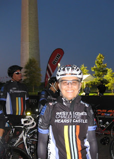
I had a special opportunity to ride a second time for Best Buddies this year, and so I found myself in Washington, D.C., staging with the rest of the pack near the base of the Washington Monument before dawn on a loaner Cannondale bicycle.

We rolled out and turned onto Pennsylvania Avenue, paced by a lead car at a nominal 12 mph. They told us that the roads would be closed for us for the first 10 miles. They didn't tell us that one of the first roads was under construction.

Cameron Wurf approaching in the unpaved lane, seconds before I crashed. (Narrative Clip photo)
It was a small group, and the pack was spread out. I made a turn onto a surface that was prepared for paving, ground down and rough. The lane to my right was paved. In the pre-dawn light and pre-dawn brain fog, I decided to cut over to that lane.

Bad idea. Bad, bad, bad idea. The edge of the fresh pavement was too high and my angle of approach too shallow. My front wheel caught the lip and I was summarily slammed to the ground. Before I could get up, a second rider mirrored my mistake 20 yards ahead.

Shouts rang out. “Rider down! Rider down! Another one!”

As luck would have it, the Narrative Clip affixed to the back of my helmet captured the scene a few seconds before I crashed.

“Are you okay?” At least three guys stopped to help; a medic confirmed that I didn't need his attention. A tall rider in full Cannondale kit took charge (Cameron Wurf). My cell phone and water bottle having skittered away, it was the proverbial yard sale. My body cushioned the bike; apart from scuffing the tape at the end of the bar and dropping the chain, the bike was unscathed. My body fared less well: one shredded arm warmer and skinned elbow, a few scrapes, and ribs that would hurt more as the day progressed. Bruises would appear later, but nothing was broken.

Horses grazing in a Maryland pasture.
I climbed back onto the bike. The pack was long out of sight. “They won't wait for us,” Cameron said. “Do you mind if I push you?” With his hand on my back, we were off in side-by-side tandem. I was pedaling moderately hard and he was hardly breathing. “I wish I had a power meter on this bike!” he said with a laugh. He related a story from a (fallen) European pro, who had said this is what it feels like to be on EPO. [Being pushed.] Wow. We were moving, soon reeling in the stragglers. When the back of the pack was in sight, I thanked Cameron, expecting him to pull off.

Bird flies overhead after I pass on a long straight road in Maryland. (Narrative Clip photo)“I want to get you to the front,” he insisted. We passed some guys who knew him. “Hey! She's helping you! That's cheating!” they joked.

The closer we got to the front, the more tightly packed were the riders. I can ride in a pack, and Cameron has experience in the peleton, but these were riders of unknown provenance. “On your left!” I called out as we whirred past.

How did Cameron, who started the day at the front, end up behind me in the first place? [Evidently, he crashed, too.] And when he said he wanted to deliver me to the front, he meant The Front.

As we edged into the gap between the pace car and the lead riders, George Hincapie was at my right elbow and then ... he was somewhere behind me.
Maryland Scenic Byway C&O Canal Tour sign with Best Buddies route sign
Those early miles through D.C. and along the eastern shore of the Potomac were a blur. I lost any advantage at the first rest stop when I visited the medical tent for some attention to my raw elbow.

Before mile 20, the bike's bottom bracket was making a racket. It sounded like a loose ball bearing clattering inside with every turn of the crank. [Ugh.] Would I have to abandon? I wasn't confident that a quick repair was possible, and the time lost would force me to be sagged forward. I soldiered on, and for much of the ride the errant ball settled into some happy place and fell silent.

Sunlit yellow leaves on a distant hillside under a gray sky in VirginiaBy mile 30, the wind became a factor. It was blowing hard from the west—the general direction for today's adventure. My ribs hurt on the side that took the impact. I had been nonchalant about this century, which involved less climbing than September's. What was I thinking? The prospect of another 70 miles of rolling hills suddenly seemed daunting. I kept going.

Rolling rural road with changing leaves in VirginiaWithout a cycle computer, I had no way to judge my speed. Without a route map, I had only the yellow signs along the course to follow. My sole reference points were placards at each 10-mile mark, and the rest stops. I calibrated my effort by my heart rate and cursed the headwind. I couldn't drink while riding—the impact of the crash had shattered the hard plastic lid of my water bottle.

By mile 50, I calculated that I was flirting with the edge of the ride's 4 p.m. cut-off time. If you were still on the course at that time, the broom wagon would sweep you up (and drop you off near the finish, so you could ride ceremoniously across the line).

Colorful leaves on tall roadside trees in Virginia
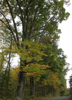
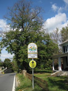
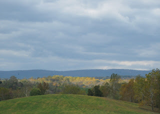
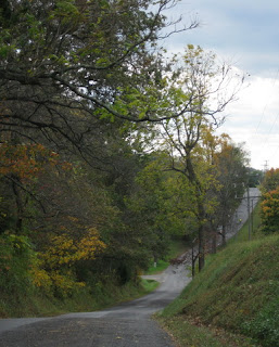
The course rolled along back roads through the woods of Maryland and Virginia. Autumn was changing the color of some leaves, but the theme of the day was green—an unfamiliar sight for those of us visiting from parched California. There were vast green lawns, meticulously trimmed in patterns by men on riding mowers. You don't see acreage like that in the West unless it's a ranch.

By mile 70, I was winning the endurance game. Few riders had chosen the 100-mile route, and they were mostly the fast guys. There weren't many fading riders on the course for me to catch, but I did pass some. A couple of ride officials trailed me at a courteous distance, but I got a gap when one flatted. SAG vehicles cruised by, some loaded with bikes and riders.
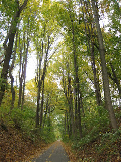
W&OD trail in VirginiaWhen I reached the W&OD trail around mile 89, I knew I was golden. I would follow this for some 10 miles, turning off close to the finish. The broom wagon couldn't touch me now! I relaxed.

I crossed the line at Morven Park around 4:30 p.m. The announcer was there to greet me. “She crashed in the first mile,” he explained to the people standing nearby. “Where's my buddy Cameron?” I asked. “He's been worried about you. I'll find him for you. You need a hot shower. Right now!” he commanded, assessing the chilled bare skin alongside my knee.

101 miles and some 4,560 feet of climbing, approximately 3500 Calories burned (and fewer consumed).

My buddy, I expect, had left the party hours before I arrived.

Thanks, Cameron, for one of my top ten moments on a bicycle.

October 17, 2014

DC

Where in the world is pep?

Not California—someplace green. A city with mass transit that works: Minutes from the airport to my hotel downtown. A city surprisingly popular with cyclists, with a robust bike-sharing program. A city with walk signals timed to allow a full 60 seconds to cross a street.

U. S. Capitol building with its dome under restoration, Washington, D.C.
A city of monuments: Our nation's capitol, Washington, D.C.

Best Buddies tent next to the Washington Monument, Washington, D.C.
Given the opportunity to bike another 100 miles for Best Buddies, I packed my bags and headed east. I spotted the staging area from the air as our plane descended past the Washington Monument. From the hotel, it was a comfortable walk to check in and get fitted on the loaner Cannondale I'd ride tomorrow.

In the late afternoon light, the walls of the Smithsonian's Castle were redder than red. I haven't visited D.C. in more than a decade, and now I regretted that I didn't have some time to be a tourist.

October 12, 2014

Hunting and Gathering

Cyclists loading their plates with the main course in a shady backyard.
It wasn't all about the bike today. Instead, we were on a treasure hunt of sorts—traveling from one spot to another for a multi-course meal. Each rider contributed a dish: appetizer, salad/side, or dessert. The club provided an assortment of dishes for the main course: ham, turkey, lasagne, green beans, corn.

The route for this annual progressive dinner changes a bit each year. After dropping off your contribution at a central location, you pick up a route sheet and pedal on to reach each location at the right time.

Turnout seemed a bit lower this year, perhaps because it was another hot day. Those who normally stick to the flat routes were surprised by a bit of a climb to earn their salads. Perched high on the hillside, we could peer down through the trees to a popular trail along the creek and the busy highway below us.

The last stop always presents a challenge. The desserts are set out in waves: If you're too eager about the first wave, you might not have room for something special from the next ... like the cake with burnt almond frosting emblazoned with the name of our club.

I covered 38 miles with a scant 1000 feet of climbing—about the same as a normal round-trip commute day. Unlike a normal commute day, I was not calorie-neutral ... not even close. [Yum.]

October 11, 2014

Fleeting

Out on this coast for business, my brother dropped by for a brief visit. I've often felt that he's not particularly impressed with California. We don't share many interests; how would I entertain him?

Flipping through the weekend listings, I realized it was Fleet Week in San Francisco. Heavy traffic, big crowds ... two reasons I've always steered clear of this event.

Coit Tower, Fleet Week banner, and a palm tree, San Francisco, California
Research suggested that BART was the way to go. From the Embarcadero station, we walked along the waterfront. After peering at the not-yet-commissioned U.S.S. America (from afar), we wandered through the farmers' market at the Ferry Building. For lunch, we found the vendor with the longest line [deservedly so] and enjoyed some fine porchetta sandwiches. He managed to overlook the arugula.

HMCS Brandon and HMCS Yellowknife, Pier 19, San Francisco, California
Apart from the U.S.S. America, and one ship being towed through the bay, we were puzzled to see more Canadian than U.S. naval vessels. People stood patiently on epically long lines to tour some out-of-sight ships, and we guessed those must be some of our own.

The airshow was underway as we made our way along the waterfront, seeking a good vantage point. We paused at Aquatic Park to marvel at the acrobatics. I expected the lawn to be packed; it wasn't. We slipped into a gap at the water's edge, inching forward into the second row as others moved away.

Patriots Jet Team in formation over San Francisco Bay, California
Trailing red, white, and blue smoke, the Patriots Jet Team warmed up the crowd. As two jets split into opposing arcs, I smiled. I realized they would trace a heart in the sky, but a third jet surprised me by piercing it through.

Three Patriot Jets trace a heart and pierce it, San Francisco, California
To the east, the Blue Angels cruised by in the distance as another acrobatic interlude was wrapping up. “They're gonna come straight at us—watch!” We had scored perfect seats. I saw the smoke before I saw the jets; all six soared right over our heads.

Four Blue Angels streak across the sky, San Francisco, California
They flew straight at each other and rolled sideways to pass. They flew high. They flew low. They flew straight up. They flew upside down. [How long can they do that?]

Blue Angels fly inverted over San Francisco Bay, California
And then, as a couple of them distracted us with some tricky low maneuvers over the bay, a pair of Hornets flirting with the speed of sound roared low over our heads.

The expression on my brother's face? Priceless.

October 8, 2014

Tranquility

I'm not keen on biking long distances in the dark.

Vasona Lake, looking toward the boat dock in early morning light.With daylight savings time still in effect, I have felt discouraged by the ever-later sunrise. At the far end of the day, there isn't much light left for the long ride home, either.

I could afford the luxury of a slightly later start today; no rush to get cleaned up in time for a morning packed with back-to-back meetings. [Yay!] In the afternoon, I could leave early enough to arrive home at dusk.

A later start, though, means heavier traffic. What if ... what if I cut through the local park, instead? Having optimized my route, and being a creature of habit, I had never tried this variation in the morning. It would add some distance and subtract some climbing.

Trees with red and yellow leaves along the shore of Vasona Lake.
How did it turn out? Well, you be the judge. [I'm biased.] The surface of the lake was as smooth as glass, and the changing leaves [yes, in California] were vibrant in the early morning light.

Tradeoff: traffic for tranquility.

October 5, 2014

Loop de Loop

We returned to the neighborhood we visited last week, this time tracing a pair of loops instead of a pair of dead-ends. I looked forward to a peaceful climb through the redwoods on a hot early fall day.

I didn't expect to share the road with a steady parade of cars heading up Black. But then, if I wanted to avoid the single-lane controls on Highway 9 and the beach traffic on Highway 17, I might drive up Black to Skyline, too.

Little water left in the Lexington Reservoir, Los Gatos, CaliforniaA driver coming down the hill in a white pick-up truck reinforced the stereotype by blaring his horn. Because he doesn't like cyclists? It made no sense, we were going up the hill in the opposite lane. Similarly, he leaned on the horn again when he returned to pass us as we were still climbing. One cyclist in our group put a positive spin on it: If they're honking at you, at least you know they see you.

Having completed our first loop, we circled the Lexington Reservoir. The water level was alarmingly low, and it will get lower still. [Keep watering those lawns, people.]

At some point in the Eastern Sierras, my bicycle started putting out a loud creak with every rotation of the crank. “Is that normal?” my fellow cyclists would ask. Post-ride, I sought out a recommended mechanic at a bike shop in town. He no longer worked there, and the shop didn't have the right-sized part (bottom bracket) in stock. [Why is this so hard?] I had better luck at a second recommended shop in a nearby town: Not only did they have the part, they fixed it on the spot and applied our club's discount without my asking for it—they saw the affiliation on my jersey.

Taking stock of the day: 20 miles with a mere 2,520 feet of climbing, one quite happy cyclist, and one quiet happy bicycle.

September 27, 2014

A Touch of Fall

Western arm of the Lexington Reservoir, completely dry.
This week brought us the first day of fall, and already a chill is in the air. It seemed like a good day for a short local ride.

Some folks in our group were in for a real treat, never having climbed Montevina before. With the marine layer hovering over the coast, though, they had to take my word for the view of Monterey Bay we were denied. We did get some close-ups of the ever-shrinking Lexington Reservoir. As we descended Montevina, we met too many cars coming up the hill—too many cars for a dead-end road, too many cars driven by people unaccustomed to the road. Something about a meeting for a llama (yes, the two-L llama) group.

Exposed bed of the shrinking Lexington Reservoir, Los Gatos, California
One hill just isn't enough, so we headed back across the highway for a longer climb. The summit of Soda Springs tops out around 3,000 feet, and it was already colder than I expected. “Don't wait for me,” one rider warned. She expected to turn back, but ultimately changed her mind and followed us to the top.

We packed an impressive 4,860 feet of climbing into a short 27 miles. [Half of that distance was downhill. Think about it.]

September 20, 2014

Arcangeli's

View from Stage Road near Highway 1, San Gregorio, California
Our ride leader presented us with a choice for today's loop: clockwise for an easier climb, counter-clockwise for lunch at Arcangeli's.

[No contest.]

Cyclists reflected in window at the San Gregorio Store
This is a popular cycling route; you're never alone at the San Gregorio General Store. My photo has it all: eclectic merchandise, live music (inside), cyclists (outside), and the marine layer over rolling hills.

Arcangeli's, aka Norm's Market, is the source of some heavenly carbs. Artichoke Garlic Herb bread. Hot-out-of-the-oven Artichoke Garlic Herb bread. It wasn't hard to devour the three loaves we bought. One rider pressed a plastic grocery bag into service as a backpack to tote a loaf home. [Uphill.] That's how good this bread is. Unless you've had it, you've had nothing like it.

Curious young mottled pig sniffs us through a wire fence.
This little piggie didn't go to market. Mom was nearby, but we suspected that both of them were on the lam in the field where we spotted them.

The skies were clear by the time we started up Haskins Hill; somehow, that's always the way it is. The marine layer lifted late enough to keep us from overheating on the exposed part of the climb. One rider, less prepared, dismounted and walked up the last stretch.

For the day, 31 miles and a modest 2,280 feet of climbing. Not enough, I'm afraid, to offset my intake of heavenly bread. And that's okay by me.

September 17, 2014

Sonora Pass

I was so inspired by the Sonora Pass on my way to the Eastern Sierras that I chose to return to the Bay Area over the same route. Following no timetable, I could dawdle along the way.

View from California Highway 108 east of the Sonora Pass
A steep hairpin rounded an overlook where I found a forestry worker monitoring a distant fire near Yosemite. Bypassing the famous National Park had kept me clear of the crowds, and the smoke.

Wide river valley with smoke rising from a fire in the distance, viewed from California Highway 108 east of the Sonora Pass
The next stop that caught my eye was Leavitt Falls. Given the current state of drought, my expectations were low. Happily, some water was flowing.

Leavitt Falls, east of the Sonora Pass, California
The summit beckoned, but ... what about that cooler on the front seat of my car? Signs in the parking area recommended the bear-proof lockers, explaining that the bears know what a cooler signifies. I was car hiking, not car camping; should I worry?

View from a trail near the summit at Sonora Pass, California
As I picked my way along the crumbly trail up the hill, I wondered why I hadn't taken a few moments to don my hiking boots and grab my walking stick. Climbing back down would be tricky.

Scenic California Highway 108 approaching granite cliffs, west of the Sonora Pass
At this pace, I reckoned it might take most of the day to complete the 80-mile scenic drive. And that was fine with me.

View of the Dardenelles from the Donnell Vista, west of the Sonora Pass
My last stop was the Donnell Vista. I'm not uncomfortable with heights, but here I met my match. Gazing up at the distant lava formations of the Dardenelles was much easier than gazing down [way, way down] at Donnell Lake and the Middle Fork of the Stanislaus River. I must have never stood at the edge of such a precipice, till now.

Eastern end of Donnell Lake, west of the Sonora Pass, California
Past this point, the road snaked through the forest and delivered me to the edge of the Central Valley by dusk, bringing my fall Sierra adventure to a close.