Showing posts with label Montana. Show all posts

August 21, 2016

Grizzly Encounter

I've biked through a few hundred miles of the greater Yellowstone ecosystem. I've seen the Yellowstone River. What I haven't seen is the famous park itself.

Time for a trip to Yellowstone National Park, a few days before the 100th anniversary of the National Park Service.

The route to Gardiner was familiar—right through the Paradise Valley (on the road not taken last Monday). And it was still filled with smoke from the wildfires.

It seemed as though I reached the highway in no time. The trip was going to take less time than I'd expected, with speed limits ranging between 70 and 80 mph.

When a sign for Grizzly Encounter said “next exit,” I decided to visit. I was too hot and tired to take advantage of a tour when we had a rest stop here, last Monday.

When you hope to observe animals, timing is everything. Brutus and Bella were napping in the shade, and were just about to be switched out for another pair (Jake and Maggi).

These bears were all rescued from less fortunate circumstances; they cannot be returned to the wild. Bella had been found as a young cub, orphaned, in Alaska.

Before bringing out the new pair, a guide went into the empty enclosure and left some treats for the bears to find: peanut butter slathered here and there on logs and under rocks. You know that feeling of having peanut butter stuck to the roof of your mouth? So do the bears.

Maggi was reluctant to come out into the open; when she did, she walked around in tight circles. Our guide explained that she does that when she's anxious; they think she's reacting to the smoke from the wildfires.

Jake, on the other hand, was a show-off. When he sat up like a teddy bear, everyone reacted with oohs and ahhs—and he ate that right up, rolling around and stretching out on his back in the sunshine.

I was surprised to learn that a major food source for them in the wild is ... moths. That's right, moths. Here, one of their favorite foods is avocados—not surprising, given their calorie density.

I was feeling a bit hungry myself, so I fetched an apple and returned to watch the bears. I kept my eye on Jake, and he clearly noticed. He turned his head in my direction and sniffed. I was at least 50 yards away. This is why you need to keep food in bear-proof containers if you're camping in bear country.

Our guide had lots of practical information about staying safe in the wild. Make lots of noise (talk, sing); be a smelly human (don't brush your teeth, wear deodorant, etc.); don't sleep in the clothes you wore when cooking (lest you be mistaken for a tasty human hot dog). We learned how to distinguish between a black bear (which might be brown) and a grizzly. Powerful muscles used for digging form the hump on a grizzly's back.

But she also had a sense of humor. “You might have been told to climb a tree, if a bear is chasing you. If the bear climbs the tree after you, it's a black bear. If the bear knocks the tree down, it's a grizzly.”

So noted. I don't think I could climb a tree, anyway.

August 20, 2016

Bozeman Redux

Cycle Greater Yellowstone, Day 7: Ennis-Bozeman

This was our coldest morning yet; the weather app on my phone said 27F when I woke up. Without a dining tent, we found the breakfast tables coated with frost. [Have I mentioned that I'm really glad not to have been camping?] My hands are chapped from so much washing and cold-weather exposure, though that's actually a good thing—the organizers have been emphatic about hygiene, to keep us all healthy.

Pro tip: Cover your bicycle saddle with a plastic bag overnight; you'll start the day with a nice, dry saddle. Or in this case, a frost-free one.

Even though today's route would be our shortest, we were encouraged to get an early start. Headmistress Jennifer had negotiated a deal with the highway patrol to have a presence along a stretch of Highway 84 that passes through a scenic (curvy, narrow) canyon.

To get there, we first needed to ride again on Highway 287. The ride was less hair-raising than yesterday's, but we were also on the road at an early morning hour.

At mile eight, we started a four-mile climb. Along the way, a roadside sign educated us about this route: “The road over Norris Hill already existed when it was used in 1864 as an extension of the Bozeman Trail from Bozeman and the Gallatin Valley to Virginia City.”

Once I reached the top, I chose to fly down the other side. The traffic-moderated canyon was five miles ahead at Norris, and I wanted to be sure of getting through it peacefully. With no headwind to fight, I achieved a top speed of 49 mph. [I passed a few riders.]

In the canyon, traffic was slowed by our own support vehicles as well as the highway patrol. It was a lovely ride.

Having left the Madison River in Ennis, we found it again as we rode through the canyon.

I was surprised to see a small flock of white pelicans floating with the current, conserving energy. As I watched the river flow at our rest stop, I also spotted two round furballs (one large, one small) floating along—beavers, most likely.

Closer to town, there was one steep-ish pitch to climb, much to the dismay of many tired riders.

We finished at the headquarters for the Greater Yellowstone Coalition, a familiar sight for me by now (due to its proximity to the Gallagator Linear Trail). Our shortest day of riding, 59 miles with 2,240 feet of climbing.

The end was ... anti-climactic. Lunch was a barbecue, but the promised “ice cream bar, with all the fixings” turned out to be individual frozen cups and some chocolate syrup. [I rectified that later, with three scoops of locally-churned huckleberry ice cream after dinner.]

Riders gathered up their stuff and scattered; only a few packed their own bikes. I found my box—already labeled for the return trip—and set to work disassembling and packing.

Now that it was done, what did I think of Cycle Greater Yellowstone?

I'm glad I did the ride; how, otherwise, would I know that I could?

The route is different each year, and some folks return again and again—I don't expect to be one of them. For me, there was too much riding on highways; the stress interfered with my enjoyment of the scenery.

I also think the event is best suited to those who camp. Camp-based activities, like yoga and musical performances, were too hard for non-campers to take in, what with limited support for shuttling between camp and hotel. Camp was, obviously, the social center; not being there also meant fewer opportunities to get to know fellow riders.

The biggest surprise for me was that, throughout the ride, I never felt tired. Or sore. I expected that I would collapse early each night, falling asleep as soon as my head hit the pillow, but that was not the case. Not being sore meant that I was in good enough shape. Not being tired, someone told me, meant that I was eating enough. [Eat to bike, bike to eat.] Nonetheless, I dropped a pound—despite the enormous cinnamon bun I had for breakfast one morning. Evidently my body was sufficiently tuned to burn some reserves of fat, which I was most happy to put to good use.

My stats for seven straight days pedaling around in southwestern Montana: 519 miles, 18,865 feet of climbing, and about 15,515 kcal burned. Amazing what the body can do.

August 19, 2016

Ennis

Cycle Greater Yellowstone, Day 6: Dillon-Ennis

Another rider arrived as I was parking my bike. “What did you think of that road?” he asked. The road was fine, it was the drivers that were a problem. “I'm done,” he replied. “They can SAG me to Bozeman tomorrow.”

I walked past the information desk as another rider was sharing his feelings about today's route. He was a local, from Livingston; I'd chatted with him a few times.

Headmistress Jennifer was on the phone with the highway patrol, making arrangements for some support tomorrow morning.

But I've gotten ahead of myself.

It was chilly this morning, with a threat of some rain (which, luckily, never materialized).

I started rolling shortly after 7 a.m., and was nearly two miles down the road when I realized I hadn't yet started recording my GPS track. By now you'd think I'd have this routine nailed.

Our first stop was near a famous limestone outcropping known as Beaverhead Rock, another critical landmark tied to the Lewis and Clark Expedition of 1805. Here they sought (and found) Sacagawea's people, the Shoshone. We also learned that prehistoric creatures (titanotheres) grazed in these fields some 30 million years ago, their fossilized remains having been found in the 1980s.

We were encouraged to take some time to see the sights along the way; it promised to be an easy day, and we would pass through a pair of historic gold mining towns, Nevada City and Virginia City. These days, they're both tourist attractions.

Piles of broken rock litter the landscape, evidence of the hunt for gold.

I was glad I stopped first in Nevada City, where I picked up a large ginger cookie at the Star Bakery. [The cookie was embossed with—you guessed it—a star.] Nevada City had a more rustic feel; Virginia City was crowded with tourists and souvenir shops; biking safely through there commanded full attention.

The trouble had started much earlier, though. We needed to travel on Highway 287 from Twin Bridges to Ennis—about 45 miles. And so did everyone else.

The shoulder was more narrow than a bike lane (when there was a shoulder). The headwind was ferocious; the crosswinds were worse. The winds alone challenged me to keep the bike upright, but the mightiest challenge came from what I'll call the “wash” (or “reverse draft”) of tractor-trailers traveling at 70+ mph in the opposite direction: generating a massive blast of air. I realized that the prudent solution would be to stop the bike and step off the road if I saw a truck approaching (and, sometimes I did). It was also a challenge not to get sucked into the lane with the draft of the trucks that passed alongside us.

Some of this problem was just bad timing: We were on this stretch of road in the afternoon, when drivers are particularly impatient as they feel pressed to get wherever they're going. Slowing to pass cyclists, or giving us a little more room, was not factored into their plan for the day.

Climbing out of Virginia City wasn't bad; the road was engineered with a second (slow) lane for the climb, so we finally got a break. Once I reached the top, well, I knew what to do. [Go fast. Go really fast. Go as fast as I possibly could, down the hill. Go go go.] Even that was treacherous, as I was buffeted by the crosswinds. I made myself as aerodynamic as possible, hung on for dear life, and hoped for the best.

Last night, one of the EMTs had mentioned that this area was known for strong winds, and he was surprised at how lucky we'd been so far. [Indeed.]

I made it. 72 miles, with 2,565 feet of climbing.

After gathering my things, I realized that Ennis was the town where I'd managed to book a cabin located right next to camp. I could just walk there.

Sweet.

August 18, 2016

Dillon

Cycle Greater Yellowstone, Day 5: Dewey-Dillon

Mother Nature smiled on us; by morning, the day's rainy forecast had changed. Last night's brief showers cleansed the smoky air and bestowed lower temperatures.

After shuttling back to camp, I rolled out with the first band of riders. We were headed for the Pioneer Mountains National Scenic Byway, a left turn that was just a stone's throw from the Wise River Club.

A small plane landed as we passed the airport. [Airport?]

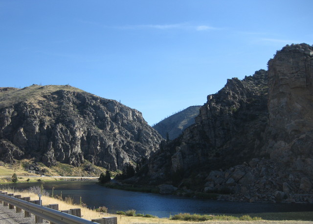
The Byway was a long, gentle climb that took us past Crystal Park. A volunteer at our nearby rest stop not only answered questions and displayed a small collection, he welcomed us to choose a small crystal from a container of samples—no need to dig! I chose a piece of smoky gray quartz, which seemed fitting for this trip. Given the long day ahead, I pedaled past the park itself. I was impressed that it was open for digging, though; generally, removing things from a park is prohibited (not encouraged).

We crossed the Continental Divide again. Presumably it was the highest point along the Byway (unmarked, but evidently about 7,800 feet). The altitude has not bothered me on this ride so far, but then I typically start to notice it above 8,000 feet.

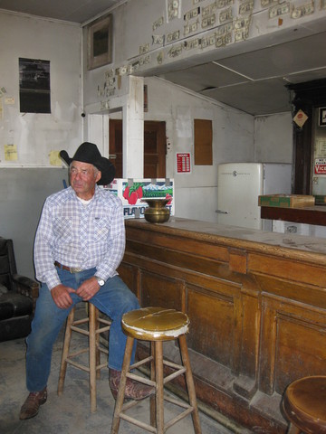
Our next stop was on private land in the tiny community of Polaris, where the present owner of its historic Polar Bar was proud to host us. Improbable as it seemed, Polaris has a Post Office. I had been seeking a stamp to mail a get-well card, and I managed to land in this tiny place during the short hours that its Post Office as open. As you might imagine, the postmistress was eager to chat.

Why do rare things happen on rides far from home? In Corsica, a sidewall cut (and low-speed blowout) taught me the importance of packing a spare tire. (I was lucky to borrow a tire from a better-prepared friend, then; now I bring one.)

On this ride, I didn't bring my usual little first-aid kit. It's a supported ride, after all. And I can't remember the last time I actually needed to use it.

Headmistress Jennifer had briefed us thoroughly on the safe crossing of cattle guards. No problem, I've crossed many. I was carrying some speed, just a few yards from one, when ... YEOWW! An unlucky bee managed to slip between the visor of my helmet and the top of my sunglasses.

In its final act, the bee managed to inject some venom into the tender flesh above my left eye. I needed to keep the bike steady, I needed to swipe at the bee in case it wasn't done, I needed both hands on the handlebars, I needed to keep moving across the cattle guard without braking hard, I needed not to crash.

My first aid kit at home has some anti-sting swabs. The EMTs didn't.

Lunch was late along today's route, around mile 65. At the briefing last night, we were told what a special place Bannack was—but not why. By the time I arrived, hot and hungry, I was focused on finding some shade and eating lunch. The last bit of road was packed dirt. Returning to the main road would entail a prolonged, exposed climb; I didn't linger and would only learn the significance of Bannack later. Thus, I had no clue that there was a ghost town on the site.

Some riders were fussing about a challenging climb late on the route. At lunch, SAG drivers were loading up bikes and people, actively offering rides. [I'll have none of that, thank you very much.]
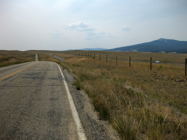
As we approached The Hill, I thought it would be nice if there were some shade. And lo, the sun slipped behind the clouds. Surprised when I reached the top, I honestly said “That was it?” At the end of the day, I'd biked 88 miles and climbed 3,980 feet, and I was feeling just fine.
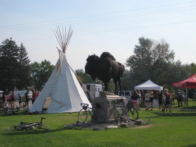
The small town of Dillon rolled out the red carpet for us. For a donation to their youth organization, moms with SUVs lined up to shuttle us to and from our hotels (past the headquarters of the Great Harvest Bread Company!). The Dillon Junior Fiddlers performed as we ate dinner. Most of the town turned out to see the encampment in their downtown park before the night was over.

The mood turned somber when we learned that we lost a rider today. [Which explained the sirens and ambulance rushing toward town on the main road as I climbed up from Bannack.] Before reaching the lunch stop, the last rider on the course gave a “thumbs down” signal, before collapsing. He was 74, and was actually doing this ride to train for another event. [Believe me, you're not doing this ride if you're not fit.]

He was not alone; support was right there, monitoring his progress. We have a dedicated crew of EMTs traveling with us; they reached him within minutes. At the hospital, the doctor said that there was nothing that anyone could have done.

Was he pushing himself just a little too hard today, pressing on in the heat to reach a lunch stop so late in the day? Or was it, as the doctor said, “his time?” Rest in peace, fellow adventurer. Rest in peace.

August 17, 2016

Dewey

Cycle Greater Yellowstone, Day 4: Whitehall-Dewey

I've begun to see a pattern. Most people on this ride came along with a buddy (or a small group), and they draft each other or form short pacelines. Each day, I've been passed by a group I dubbed “Team BMC” (a couple of them wear BMC jerseys). Each day, they pass me and then slow down. Catch the target, mission accomplished. Now riding at a slower pace than I wanted, I would pass them. [Lather, rinse, repeat.]

Today, however, their pace was adequate. Maybe they're getting tired. I figured, if you can't beat 'em, join 'em; they weren't taking turns, anyway. They looked at me a few times, but I hung on at the back of their paceline until some little uptick in the road or another divested me.

A gentle climb led to our first crossing of the Continental Divide, at Pipestone Pass. Crossing the Continental Divide seemed like a big deal to me, but apparently not to the state of Montana. No sign marked the spot, but evidently the elevation is about 6,453 feet.

There have been some fine snacks at our rest stops. Fudgsicles (I confess, I ate two). A new CLIF bar product—nut butter filled. And a make-your-own revelation: half of a flour tortilla, upon which one slathers peanut butter and Nutella. [Oh, yum!] I think there will be more of those in my future.

Headmistress Jennifer had considerable angst about our route through Butte; she's not an urban rider. From a distance, we could see the upper walls of the massive Berkeley Pit (former copper mine that is now a Superfund site).

A lovely trail led us out of town on the other side of the tracks, straight to ... I-15 South. Sometimes there just isn't another road between towns, and when that happens, bicycles get to use the Interstate. [That's right, the Interstate highway.]

The shoulder was wide, the highway patrol was stationed with flashing lights at our onramp, and they lit an electronic sign in our honor: BIKES ON ROAD, DRIVE CAREFUL [sic]. Truck drivers were particularly respectful, moving over to the left lane. I may not have driven on a road where the speed limit is 80 miles per hour, but here I was biking on one. After about three miles, we took the next exit and continued along a frontage road.

Yes, another frontage road. Yes, another hot day. Yes, another interminable, exposed climb. There's always a headwind. A ladybug hitched a ride on the frame of my sunglasses.

After peaking around mile 48, I decided it was time to boogie. With a slight downhill assist, I cranked it up in excess of 20 mph for the next half hour and blew past fading riders. Making up for lost time, I managed to cover the the distance (65 miles, with 3,110 feet of climbing) at an average pace of 12+ mph.

At the town of Divide, we turned into a valley along the Big Hole River. A large bird soared high above the river; a flash of white tail feathers confirmed a hunch: Bald Eagle.

As we visit each town, we tap the local residents for volunteer help. A driver who gave us a ride to the ranch last night seemed amused that we were heading next for Dewey. “I have never been to Dewey,” she said emphatically. We were warned that we would be out of cell phone range.

Camp set up not far from the river; a few folks cooled off in the water, and at least one tried his luck at fly fishing.

Having booked early enough, I was fortunate to score a room a few miles down the road in the town of Wise River; most non-campers were shuttled to a motel back in Butte (an hour's drive).

And what a score it was! I was promised a room above the saloon, with a shared bathroom. I'd been reassured that this would be fine, as it was not a weekend and there wasn't much fishing action because the water level was low.

My room was right up front, next to the communal balcony (where my laundry dried in no time, with the wind). Of the entire trip, this room was my favorite.

Sheltered from the raindrops on the balcony, I watched lightning streak across the sky. So happy not to be in a tent tonight. So happy.

August 16, 2016

Whitehall

Cycle Greater Yellowstone, Day 3: Bozeman-Whitehall
More smoke today, this time from a grass fire that might require a diversion in our route. Although GPS tracks had been helpfully provided before the ride started, we were reminded to follow the road markings (and route marshals) to stay on course. Yesterday's track, for example, showed a return route from Emigrant on the highway (rather than backtracking on the quieter parallel road), a plan that had been changed.

This morning's route made us all feel supercharged: it looked flat, but was a gentle downhill. For the first two hours I averaged 17 mph. [So that's what it feels like to be a faster rider!]

A couple passed me, then slowed down. I passed them. They passed me. After a few rounds of leapfrog, the husband finally picked up the pace. I left a gap for his wife, but she didn't fall in; instead, she drafted me, I drafted him. We arrived together at the first rest stop, and I thanked him for the pull. They introduced themselves, and she said “You're amazing! You're so consistent!”

There is a lot of Lewis and Clark history along our route. In the town of Three Forks, the grounds of the Sacajawea Hotel accommodated us for a rest stop. A bicycle trail led us to (and from) lunch, and there I learned what it's like to follow a rider who is not consistent.

He would spin spin spin really fast, then coast. Spin spin spin like crazy, then coast. It was maddening. At the first opportunity to slip past him, I did.

Much of the terrain has reminded me of our rides in the Eastern Sierras, which left me pondering whether I should simply have joined that ride again this year.

But then we followed the Boulder River through a scenic canyon, and I perked up. I also couldn't resist the chance to snap some photos from a locomotive's perspective, as the tracks were right there, with plenty of visibility to spot any oncoming trains. [There were none.]

Our approach to Whitehall gave us a straight-on view of the enormous open pit hardrock Golden Sunlight mine (in particular, the waste rock filling a valley). From camp, we had a view of the back side. These mines create huge toxic hazards, with the potential for cyanide runoff and a great volume of acidic water, that will endure for years. (Centuries?)

Even though this was a 76-mile day, with only 1,160 feet of climbing it was a fast trip. I gathered my stuff at camp and looked for a shuttle to the bed-and-breakfast ranch where I'd be staying. Maybe the shuttles would start before 3 p.m., since most people were done riding.

Nope. In fact, they wouldn't start till 4 p.m. How would I get cleaned up and back to camp for dinner by 5:30 p.m.?

I was one unhappy (non)camper, hungry, overheated, and gritty with salt, sunscreen, and road grime.

The only sensible solution was to make one trip, after dinner, to the ranch. I claimed a towel, used the shower truck, washed out my bike clothes and strung them up to dry on a fence. I had been curious about the Laundry Pods, anyway; now I had the opportunity to use one. (It's a manual washing machine—think salad-spinner-for-clothes.) It worked quite well.

Of course, I was free to use all these facilities, and once clean I was considerably less grumpy.

The Iron Wheel Guest Ranch was on the outskirts of town; tomorrow, we would cycle past it. The property is the site of an old stagecoach stop on the Yellowstone Trail; what could be more fitting than running a modern-day equivalent? The proprietors took good care of us—even rising early to supply us with a hearty breakfast the following morning—and proudly gave us a tour of their taxidermy workshop.

Authentic Montana, genuine folk. Just as I'd hoped it would be.