One of the club's annual getaways was this weekend, but I'm not much of a camper. A local ride fit the bill, though the route would be a tad shorter than I wanted. Riding to (and back from) the start would fix that.
The pace was mellow, the air seemed clear, the temperature was just right. It was a breeze, literally. We snaked through a maze of residential streets on our approach to Stevens Canyon. The group stayed together so well that there was no need for the first re-group we'd planned.
A change in elevation was all we needed to spot the lingering smoky haze.
More than once I found myself keeping pace with, or gaining on, another rider on the downhill stretches—without trying. He was keen on optimizing aerodynamics, and I was just letting the Cervélo carry me along. When an unlucky bee caromed off my upper lip, I was reminded why it's important to keep your mouth closed (and your jersey zipped) while descending.
Roadwork (bridge construction) has continued on upper Stevens Canyon Road. It seemed particularly wasteful that they'd left two generators running, for no apparent reason. This being a Sunday, there were no work crews onsite. And even though I'd just cycled here a few weeks ago, I was surprised when I reached the gate—the last of the wood-planked bridges are gone! Safer for cycling, but kind of sad to lose them nonetheless. It is a mystery why the county is building such beefy bridges on this remote, effectively dead-end road.
At the top of our final summit, the group voted to reverse course rather than descend Highway 9. Having been undecided, I cast my lot with the majority. Highway 9 would be more direct, but ... did I really want to tangle with simmering beach-bound motorists, stewing in their cars? Diverted once again by the downtown street closures designed to keep them from clogging local neighborhoods.
I settled into my familiar commute pattern, strategizing about which route would be best to avoid the thwarted traffic as I got closer to home. My thoughts turned to lunch (“bike to eat,” after all) ... I could enjoy a nice sandwich at Erik's, but that might entail dancing with traffic. With a subliminal prod, perhaps, it dawned on me that I had just passed a different Erik's location. U-turn!
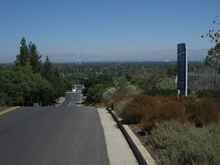
Thus fortified, and feeling strong, I needed More (Avenue). It seemed easier than I'd remembered. Until I got to the last bit, which was as steep as I'd remembered. (Yikes!) In the photo, notice how the road appears to drop off, like the edge of a cliff? Yup, it does that. (That's what I climbed.)
Flush with triumph, I decided to go exploring. I'd seen a cyclist turn onto a side street, let's see where that goes. Another right turn and I was heading downhill ... would I need to climb back up? [No!]
Back to my regular route, and ... there's the edge of the traffic. Decisions, decisions ... one lane is blocked, encouraging them to turn. Straight ahead for me, then! Till I caught up to the next clog. Left turn, bypass!
For whatever reason, I was still feeling frisky. I had actually passed some folks in our group on climbs today. It was still early, why not climb a couple more hills? [So, I did.]
For the day, 44 miles, 3,020 feet of climbing. That's respectable, I'd say.
August 7, 2016
Subscribe to:
Post Comments (Atom)


No comments:
Post a Comment