I have seen more
Caltrans trucks in two days in the Eastern Sierras than I've seen all year in the Bay Area. Everywhere, roadwork.
We learned that the upper portion of Rock Creek Road had been pulverized in preparation for re-paving, which disappointed some and delighted others. I fell into the first group, having never climbed it. The second group included many who had.
In his
Complete Guide to Climbing (By Bike) books, John Summerson listed Rock Creek as the 10th most difficult climb in California, and 26th in the United States. The climb tops out at an elevation of 10,220 feet, the end of the highest paved road in California. I would not find out today whether I could turn the pedals at that altitude, and the road work may not be completed by this time next year, either.
Lower Rock Creek Road passes through Paradise, which (as one might expect) is not a crowded place. Population: 120. Reaching Upper Rock Creek Road entails a short trip on
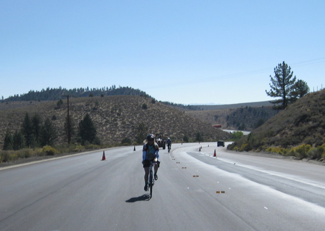
U.S. Route 395. Three of us (the stragglers) reached the highway ... and paused. That stretch of road was being re-paved; all vehicles were being funneled into the rightmost lane, which was barely wide enough for the tractor-trailers lumbering through and which had no shoulder whatsoever. [Yikes.]
Luckily, a worker was nearby and directed us to ride in the closure: smack down the middle of the highway! Queens (and King) of the Road, we were.
There was some uncertainty about how far we could venture on Upper Rock Creek. The pavement might end six miles up the road, or at 1.6 miles. Heavy equipment was tearing into the right lane of a bridge over the creek. A flagman waved us through, and a descending rider told us we could go up four miles before the pavement ended. [Yay!] Later we would be the envy of the rest of our group: everyone else had turned back at this bridge, discouraged by the flagman and a long line of cars.
Shortchanged by Upper Rock Creek, we headed northwest for a consolation climb along McGee Creek. Returning riders cautioned that it was steep: 12-14% grade. “You'll need your low gears,” they advised. Not to worry; my lowest gears get a lot of action.
We felt intimidated, but we did not turn back. The grade felt more like 9%, and my stats later confirmed my hunch: 8.8%. My heart rate spiked at one point, so there definitely was a steeper segment (for a distance of about 20 yards). We were rewarded with views of Crowley Lake and celebrated with treats at the local bakery; then we realized that we faced more climbing in retracing the morning's route. Remember that long, sweeping descent on Lower Rock Creek? [Uh-oh.]
We were astonished to enjoy the wide shoulder of U.S. 395 on our return—road markings were fully painted, and the workers were collecting the safety cones and temporary markers. All in the same day! In the Bay Area, temporary markers can be in place for
weeks before the lanes are striped.
Being the few who completed the full route, and being slow, we were the last to roll back to the start. And proud, we were:
51 miles, 6,005 feet of climbing.


Once on Sand Hill Road, a construction worker had delimited a bike lane through a section of coned-off road. He must have been a cyclist.
ReplyDelete